It’s possible that I shall make an ass of myself. But in that case one can always get out of it with a little dialectic. I have, of course, so worded my proposition as to be right either way (K.Marx, Letter to F.Engels on the Indian Mutiny)
Monday, October 06, 2025
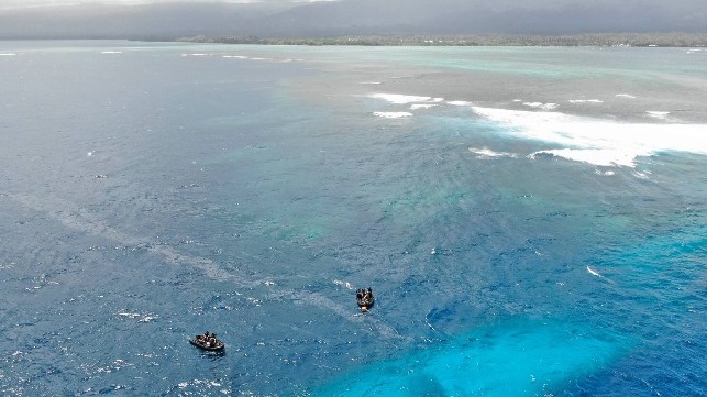
Qatar Orders Ships to Halt Navigation in its Waters Due to GPS "Fault"
On Saturday, Qatari authorities took the extraordinary step of ordering all shipping interests to stop navigating because of "a technical fault in the GPS," officially bringing the country's maritime commerce to a halt.
The ministry said that the order would remain in effect indefinitely until the issue is resolved. The nature of the fault was not disclosed, but GPS interference is a routine issue in the Arabian Gulf, particularly at times of heightened tensions between Iran and its geopolitical opponents. In recent months, Qatari citizens have reported frequent GPS errors affecting their personal mobile devices, all showing a virtual and erroneous "location" in Iran.
This form of spoofing is a common electronic warfare technique, and is typically applied as a defensive measure to throw off the guidance systems of inbound attackers and their weaponry. It may also be used as a form of deniable "hybrid warfare" harassment, disrupting commerce without leaving clues to the perpetrator's identity.
The practical effect of the transport ministry's decree was not immediately clear. As of Sunday evening, marine traffic appeared to be moving briskly in Qatari territorial seas, with dozens of merchant vessels navigating at typical speeds near Doha and Ras Laffan. Qatar is the one of the world's leading exporters of natural gas, and any interruption in its LNG carrier traffic would have an effect on global energy markets; despite the decree, typical berthing maneuvers appeared to be under way at the loading piers in Ras Laffan's inner harbor as of Sunday.
GPS spoofing incidents are usually treated as an inconvenience by shipping interests, an added risk but not a cause for cessation of operations. The central Baltic Sea has been subjected to constant GPS spoofing and jamming for years, without interrupting the flow of marine commerce (though it has a more serious effect on aviation). Researchers believe the Baltic jamming to be linked to powerful GPS spoofing transmitters, likely operated by a nation-state actor.
New Zealand Plans to Pay Samoa $3.6 Million for Sinking of HMNZS Manawanui
Divers investigate the Manawanui's wreck site, 2024 (Royal New Zealand Navy)
On the one-year anniversary of the sinking of the HMNZS Manawanui, the government of New Zealand has agreed to pay Samoa a total of $3.6 million in compensation for the contamination and disruption from the loss of the vessel.
"We have always said we will do the right thing," New Zealand Foreign Affairs Minister Winston Peters said in a statement Sunday. "We recognize the impact the sinking has had on local communities and acknowledge the disruption it caused."
HMZNS Manawanui was a 2003-built offshore support, dive and survey vessel, originally built for Østensjø Rederi and named the Edda Fonn. She was sold to the Royal New Zealand Navy in 2018 and refitted for military missions. On October 5, 2024, the ship was operating about one nautical mile off Opolu in rough and windy conditions. At about 1815 hours, the crew made a normal turn to starboard, but the ship did not respond to their rudder commands because it was still in autopilot. It then accelerated towards the reef and grounded at 10 knots, continuing onwards for 400 yards before stranding. 75 personnel abandoned ship at about 2200 hours, and all were rescued. Only 14 were injured, including several who had cuts from walking across the coral to safety. The generators were left running to aid the evacuation, but the next morning they caught fire catastrophically, resulting in the ship's capsizing and sinking.
A court of inquiry found that training issues and the qualifications of the ship’s personnel were to blame for the grounding, with contributing issues in operational planning, instructions and procedures, supervision, haste, leadership, distraction, and interruptions. New Zealand's navy has pledged to revise its procedures to reduce the risk of recurrence.
The ship went down with about one million liters of distillate on board, and an unknown amount of fuel leaked from the tanks. The comparatively remote location of the wreck site delayed the start of pollution abatement operations, but a barge arrived on site in December 2024 and pumping out was substantially completed in February. Local fishermen were banned from the area for five months over contamination concerns, resulting in loss of income.
There are no plans to attempt to raise the ship from the bottom, and some local stakeholders have objected to the wreck's continued presence. Some village elders told RNZ recently that the fishing on the reef has been very poor since the sinking compared to historic levels of abundance, and others have complained of a continuing odor of diesel on the water.
However, sampling has produced no signs of serious widespread pollution, and the Scientific Research Organization of Samoa has concluded that the seawater near the site is uncontaminated. The New Zealand Navy says that it is moving ahead with an independent assessment of the wreck site post-remediation, and that it remains a priority to minimize environmental impact.
HMNZS Manawanui will not be replaced, and her missions will be picked up by the patrol boat HMNZS Otago - a much smaller vessel lacking Manawanui's working deck and 100-tonne crane.
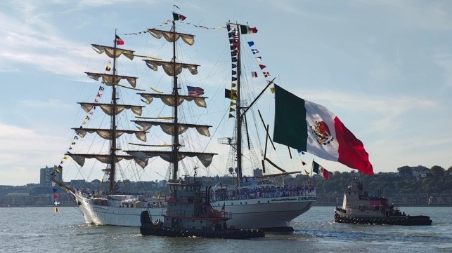
Tall Ship Cuauhtemoc Departs New York After Collision Damage Repairs
TS Cuauhtemoc gets under way, October 4 (Mexican Embassy in New York)
The damaged sail training ship Cuauhtémoc has been repaired at a shipyard in Staten Island, and on Saturday it departed Manhattan en route for its home port of Cozumel, Mexico. The departure ends the ship's long six-month sojourn in New York City and brings the saga of the vessel's accident to a close.
On the evening of May 17, Cuauhtémoc left Manhattan's Pier 17 with dozens of cadets aloft in the rigging for a ceremonial departure. Under the guidance of a docking pilot, the vessel moved astern and away from the pier, but then - for reasons that remain under investigation - her maneuvers deviated from the pilot's orders. The docking pilot ordered ahead propulsion, but the vessel accelerated astern. Within minutes, the tall ship hit the underside of a span of the bridge, breaking three masts. Tragically, two people were killed and 22 injured.
Cuauhtémoc sustained serious damage aloft, and her rudder post was deformed and jammed over to starboard. Repairs to the vessel took four months, and the ship was ready to return to service in late September. She returned to a pier in New York for a public tours, then prepared to get under way at last. She departed the harbor on Saturday afternoon, without further incident - and this time, without anyone aloft.
The investigation into the cause of the casualty is still under way, led by the National Transportation Safety Board.
Expedition Mounted to Follow New Lead on Amelia Earhart's Crash Site
A satellite image shows the Taraia Object in a lagoon on Nikumaroro Island. (Photo provided by Rick Pettigrew, Archaeological Legacy Institute / Purdue)
Researchers at Purdue University and the Archaeological Legacy Institute (ALI) are set to head out to a remote island in the South Pacific for a new search for the wreckage of Amelia Earhart's lost airplane, which disappeared in 1938 during a circumnavigation attempt. Nine decades later, the plane and her remains are still missing, despite countless expeditions.
The Purdue expedition will examine an "anomaly" in the lagoon at Nikumaroro (Gardner Island), the locus of many theories about her final resting place. The island is a tiny coral atoll some 1,800 nautical miles southwest of Hawaii in the middle of the vast Pacific. It is 350 nautical miles south of Howland Island, Earhart's intended destination. The International Group for Historic Aircraft Recovery (TIGHAR) has investigated sites on Nikumaroro since the 1980s.
The visual anomaly that caught the eye of the Purdue team is the "Taraia Object," a distinctive shape that appears in historical videos and photos of the lagoon. As early as 1938 - the year of Earhart's disappearance - aerial photos of Nikumaroro picked up a faint, grainy blur near the shoreline just opposite the inlet. Satellite imaging picked up something similar at the same site in 2015-16. The Archaeological Legacy Institute (ALI) has had its eye on this object for years, and thinks that the protrusions are the tail, fuselage and starboard wing of Earhart's plane.
ALI has solicited enough funds to mount an expedition to thoroughly investigate the site, and it is no small matter. The team will fly to Majuro in the Marshall Islands, then sail about 1,200 nautical miles to reach Nikumaroro, departing November 4. The long journey will allow them several days' time on the island. They will examine the site with a magnetometer, then excavate with a hydraulic dredge to see if there is something beneath the sands.
“A successful identification would be the first step toward fulfilling Amelia’s original plan to return the Electra to West Lafayette after her historic flight,” said Steve Schultz, field assistant and Purdue senior vice president and general counsel. “Additional work would still be needed to accomplish that objective, but we feel we owe it to her legacy, which remains so strong at Purdue, to try to find a way to bring it home.”
The Earhart story has attracted explorers and archaeologists for years. In 1937, Earhart and her navigator Fred Noonan took off from California for an attempted round-the-world journey. Their twin-engine Lockheed Electra airplane had a range of about 4,000 miles, so they had carefully planned a series of refueling stops along the way, with assistance from the U.S. government. They took an eastbound route, and in 21 days they reached New Guinea. After repairs and refueling they departed for Howland Island, an isolated atoll where a new airstrip had been prepared and provisioned for them. They never arrived, and after a search, they were declared lost at sea.
The real reasons Endurance sank — study finds Shackleton knew of ship’s shortcomings
A world-first study reveals the famed polar explorer was aware of worrying structural shortcomings in the ill-fated ship — Endurance was not designed for compressive ice conditions — yet it set sail anyway.
Sir Ernest Shackleton’s ship, Endurance, was crushed by Antarctic sea ice and sank in November 1915. Emblematic of the heroic age of Antarctic exploration, it is widely considered the strongest polar ship of its time, albeit with a fatal flaw — a weakness in the rudder that caused the ship to sink.
Now, a world-first study incorporating both technical analysis and research into diaries and correspondence sheds new light on the expedition and the man himself. Not only did the ship have structural weaknesses that made it notably less robust than other early polar vessels but also, remarkably, the famed explorer was well aware of them before he set sail.
‘Even simple structural analysis shows that the ship was not designed for the compressive pack ice conditions that eventually sank it,’ says Jukka Tuhkuri, a professor of solid mechanics at Aalto University, and one of the world’s foremost ice researchers. ‘The danger of moving ice and compressive loads — and how to design a ship for such conditions — was well understood before the ship sailed south. So we really have to wonder why Shackleton chose a vessel that was not strengthened for compressive ice.’
A polar explorer himself, Tuhkuri was one of 15 scientists who were invited to join the Endurance22 mission, the team that discovered the wreck in 2022. Surprised that fundamental structural analysis of the vessel had never been conducted, the wreck’s discovery fuelled his own desire to reveal the scientific truths behind the legend.
‘Endurance clearly had several structural deficiencies compared with other early Antarctic ships,’ he explains. ‘The deck beams and frames were weaker, the machine compartment was longer, leading to serious weakening in a significant part of the hull, plus there were no diagonal beams to strengthen the hull. Not only does this challenge the romantic narrative that it was the strongest polar ship of its time, but it also belies the simplistic idea that the rudder was the ship’s Achilles’ heel.’
After analysing Shackleton's diaries, personal correspondence, and other communications from the crew, what is less clear to the researcher is why the famed explorer chose to sail into the dangerous Antarctic ice pack aboard Endurance.
‘Shackleton knew about this. Before he set off he lamented the ship’s weaknesses in a letter to his wife, saying he’d exchange Endurance for his previous ship any day. In fact, he had recommended diagonal beams for another polar ship when visiting a Norwegian shipyard. That same ship got stuck in compression ice for months and survived it,’ says Tuhkuri.
So was Endurance simply “ill-fated”, or were poor decisions the real root of the ship’s demise?
Tuhkuri doesn’t want to make that judgment. He says the study doesn’t seek to detract from the heroic achievements of Shackleton and the men who travelled with him to the Weddell Sea more than hundred years ago. But he does hope it will add a new perspective to the way we look at Endurance.
‘We can speculate about financial pressures or time constraints, but the truth is we may never know why Shackleton made the choices that he made. At least now we have more concrete findings to flesh out the stories,’ he concludes.
The study was published on October 6th in the prestigious Polar Record journal.
Professor Jukka Tuhkuri researches ice mechanics and arctic marine technology at Aalto University in Finland. His laboratory experiments are conducted in the Aalto Ice and Wave Tank, the world’s only large-scale ice and wave research facility. His research into changing ice conditions due to climate change has taken him to the Arctic and Antarctic and he is author of Jään Voima (in Finnish) — his account of the sinking and discovery of Endurance.
A pre-print of the paper is available on request
Images of Jukka Tuhkuri and Aalto University’s Ice and Wave Tank are available HERE –- credit Aalto University. Images of the Endurance’s wreck are held under trust, available from the usual media image libraries under license.
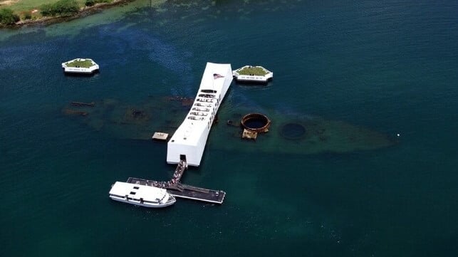
The wreck of the U.S battleship USS Arizona could see its status elevated from a solemn memorial to a ‘living laboratory’ after it emerged that oil continues to leak from the ship more than 80 years after its sinking at Pearl Harbor.
Analyzing oil samples collected from multiple points on the World War II warship, results show that oil is still seeping from the wreck. The researchers led by the University of Houston and Woods Hole Oceanographic Institution (WHOI) used advanced molecular fingerprinting techniques to analyze the samples collected by the National Park Service (NPS) in 2016 and 2018. Results have confirmed the oil is heavy fuel oil refined from California crude, consistent with U.S. Navy fueling practices in the early 1940s.
Despite the sunken warship being underwater for decades, the oil retains high concentrations of polycyclic aromatic hydrocarbons (PAHs), compounds known for their persistence and potential toxicity. The researchers have published their findings in the Marine Pollution Bulletin.
The findings underscore the fact that apart from holding the status of being a solemn war grave, Arizona's wreck has the potential to become a ‘living laboratory’ for understanding the long-term fate of petroleum trapped in shipwrecks. The wreck has an estimated 600,000 gallons of oil still on board, and has a need for ongoing monitoring.
Oil is not leaking at a highly concerning rate from the Arizona wreck, researchers say. And while it does contain PAHs, not all of them are highly toxic. Besides, although the oil comes from the same shipping fuel, it changes chemically before it escapes. As it moves through the maze of wreckage, it encounters varying oxygen levels, water flow, and microbial activity, shaping the oil's chemistry and giving each leak a unique fingerprint.
The U.S. Navy is in the process of removing two aging mooring platforms that were welded onto the wreck in order to preserve her memories and hundreds of servicemen who perished in the aftermath of the Pearl Harbor attacks. The Arizona Memorial honors 1,177 crewmen who died in the attack, among them more than 900 sailors and marines.
“As one of America's most hallowed war graves and the site of tragedy and sacrifice at the outset of a global conflict for our country, the site demands the best and most considered science we can muster,” said David Conlin, a marine archaeologist with NPS. “The work we have completed is groundbreaking in its implications and also its respectful, non-intrusive approach to data gathering.”
The researchers contend that the findings have global significance owing to the fact that thousands of WWII-era wrecks, containing millions of gallons of unrecovered fuel, rest on ocean floors worldwide, with many being in nearshore environments. Essentially, the Arizona wreck offers a unique insight into how oil behaves over decades in low-oxygen, submerged conditions, something that can greatly inform modern spill response strategies and environmental risk assessments.
The team highlights that the chemical composition of the oil varies depending on the leak location, reflecting differing degrees of natural “weathering” processes, including microbial biodegradation and dissolution. While lighter compounds are gradually breaking down, key petroleum biomarkers remain intact, allowing scientists to trace the oil's source and behavior over time.
Chris Reddy, marine chemist at WHOI, contends that the study offers valuable insights that strengthen preparedness and planning for future operations at other shipwrecks. “When deciding whether to remove oil from a shipwreck, we weigh the risk of a potential spill against the danger of disturbing the site itself,” he noted.
He added that factors like the amount of oil remaining, the rate of leakage, the local ecosystem's sensitivity, and the cultural or historical value of the wreck all play a role. When all factors are considered, sometimes the best choice is careful monitoring rather than intervention.
Marine heatwaves have hidden impacts on ocean food webs and carbon cycling
New study analyzing data from robotic floats and plankton records reveals how marine heatwaves reshape ocean food webs and slow transport of carbon to the deep sea
Robotic floats can continuously collect detailed data about ocean conditions. A new study led by MBARI researchers from the Global Ocean Biogeochemistry Array project—with an interdisciplinary team of collaborators—has analyzed data from floats deployed in the Gulf of Alaska and records from ship-based plankton surveys and revealed that marine heatwaves reshape ocean food webs and affect the ocean’s ability to store carbon.
New research shows that marine heatwaves can reshape ocean food webs, which in turn can slow the transport of carbon to the deep sea and hamper the ocean’s ability to buffer against climate change. The study, published in the scientific journal Nature Communications today, was conducted by an interdisciplinary team of researchers from MBARI, the University of Miami Rosenstiel School of Marine, Atmospheric, and Earth Science, the Hakai Institute, Xiamen University, the University of British Columbia, the University of Southern Denmark, and Fisheries and Oceans Canada.
To explore the impacts of marine heatwaves on ocean food webs and carbon flows, the research team combined multiple datasets that tracked biological conditions in the water column in the Gulf of Alaska for more than a decade. This region experienced two successive marine heatwaves during this time, one from 2013 to 2015 known as “The Blob,” and another from 2019 to 2020.
“The ocean has a biological carbon pump, which normally acts like a conveyor belt carrying carbon from the surface to the deep ocean. This process is powered by the microscopic organisms that form the base of the ocean food web, including bacteria and plankton,” said the lead author, Mariana Bif, previously a research specialist at MBARI and now an assistant professor in the Department of Ocean Sciences at the Rosenstiel School. “For this study, we wanted to track how marine heatwaves affected those microscopic organisms to see if those impacts were connected to the amount of carbon being produced and exported to the deep ocean.”
The research team used information collected by the Global Ocean Biogeochemical (GO-BGC) Array, a collaborative initiative funded by the US National Science Foundation and led by MBARI that uses robotic floats to monitor ocean health. The GO-BGC project has deployed hundreds of autonomous biogeochemical Argo (BGC-Argo) floats, which measure ocean conditions such as temperature, salinity, nitrate, oxygen, chlorophyll, and particulate organic carbon (POC) up and down the water column every five to 10 days. The team also looked at seasonal data from ship-based surveys that tracked plankton community composition, including pigment chemistry and sequencing of the environmental DNA (eDNA) from seawater samples collected during the Line P program carried out by Fisheries and Oceans Canada.
The study found that marine heatwaves did impact the base of the ocean food web, and those impacts were connected to changes in the ways that carbon was cycled in the water column. However, the changes that occurred in the food web were not consistent across the two heatwaves.
Under typical conditions, plant-like phytoplankton convert carbon dioxide to organic material. These microorganisms are the foundation of the ocean food web. When they are eaten by larger animals and excreted as waste, they transform into organic carbon particles that sink from the surface through the ocean’s mesopelagic, or twilight, zone (200 to 1,000 meters, approximately 660 to 3,300 feet) and down to the deep sea. This process locks atmospheric carbon away in the ocean for thousands of years.
During the 2013–2015 heatwave, surface carbon production by photosynthetic plankton was high in the second year, but rather than sinking rapidly to the deep sea, small carbon particles piled up approximately 200 meters (roughly 660 feet) underwater.
During the 2019–2020 heatwave, there was record-high accumulation of carbon particles at the surface in the first year that could not be attributed to carbon production by phytoplankton alone. Instead, this accumulation was likely due to the recycling of carbon by marine life and the buildup of detritus waste. This pulse of carbon then sank to the twilight zone, but lingered at depths of 200 to 400 meters (roughly 660 to 1,320 feet) instead of sinking to the deep sea.
The team attributed these differences in carbon transport between the two heatwaves to changes in phytoplankton populations. These changes cascaded through the food web, leading to a rise in small grazers who do not produce fast-sinking waste particles, so carbon was retained and recycled at the surface and in the upper twilight zone rather than sinking to deeper depths.
“Our research found that these two major marine heatwaves altered plankton communities and disrupted the ocean’s biological carbon pump. The conveyor belt carrying carbon from the surface to the deep sea jammed, increasing the risk that carbon can return to the atmosphere instead of being locked away deep in the ocean,” said Bif.
This research demonstrated that not all marine heatwaves are the same. Different plankton lineages rise and fall during these warming events, underscoring the need for long-term, coordinated monitoring of the ocean’s biological and chemical conditions to accurately model the diverse, and expansive, ecological impacts of marine heatwaves.
“This research marks an exciting new chapter in ocean monitoring. To really understand how a heatwave impacts marine ecosystems and ocean processes, we need observation data from before, during, and after the event. This research included robotic floats, pigment chemistry, and genetic sequencing, all working together to tell the entire story. It’s a great example of how collaboration can help us answer key questions about the health of the ocean,” said MBARI Senior Scientist Ken Johnson, the lead principal investigator for the GO-BGC project and a coauthor of the study.
Ocean observations and models suggest that marine heatwaves have been expanding in size and intensifying over the past few decades. The ocean absorbs a quarter of the carbon dioxide emitted each year, thanks to the steady stream of carbon particles sinking from the surface to the deep sea. A warmer ocean can mean less carbon locked away, which in turn can accelerate climate change. Beyond the changes to carbon transport, the shifts in plankton at the foundation of the ocean food web have cascading impacts on marine life and human industry too.
“Climate change is contributing to more frequent and intense marine heatwaves, which underscores the need for sustained, long-term ocean monitoring to understand and predict how future marine heatwaves will impact ecosystems, fisheries, and climate,” said Bif.
This work was funded by the US National Science Foundation’s GO-BGC project (NSF Award 1946578 with operational support from NSF Award 2110258), with additional support from the David and Lucile Packard Foundation, China National Science Foundation (grant number: 42406099), Fundamental Research Funds for the Central Universities (grant number: 20720240105), Danish Center for Hadal Research (Grant No. DNRF145), and Fisheries and Oceans Line P program.
About MBARI
MBARI (Monterey Bay Aquarium Research Institute) is a non-profit oceanographic research center founded in 1987 by the late Silicon Valley innovator and philanthropist David Packard. Our mission is to advance marine science and engineering to understand our changing ocean. Learn more at mbari.org.