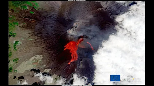
Mount Etna erupts for 50th time, space satellite captures epic image
During its 50th eruption for 2021, Mount Etna has been photographed by European Sentinel 2 satellite as it passed overhead.
Jak Connor@Jak_ConnorTT
PUBLISHED SAT, SEP 4 2021
Space satellites aren't just used for communication purposes, some are used to take images of the Earth to document natural events such as hurricane Ida, or a volcanic eruption.
Mount Etna has erupted for the 50th time in 2021, spewing out plumes of gas, ash, and lava. The 50th eruption occurred on August 30 and was documented by the European Sentinel 2 satellite with an overhead image. Volcanologists had known that Mount Etna was unstable when it began releasing clouds of ash and gas in late 2020.
According to volcanologist Boris Behncke from the National Institute for Geophysics and Volcanology (INGV), "Etna was building up for something big (we feared an eruption from the flank) with intense seismic activity, ground deformation, and degassing. On 16 February the real series of paroxysms [eruptions] started, seismicity stopped, ground deformation reversed to deflation."
Due to how active Etna has been, researchers are keeping a very close eye on Etna to measure the number of volcanic plumes it is spewing out and how the volcano is generally affecting the area. For more information on this story, check out this link here.
·18h
Magma is building up under #Askja #volcano in North-Eastern #Iceland. Currently no seismic activity recorded in the area. It last erupted in 1961, with an eruption that lasted 6 weeks. In 1875 it had an explosive eruption, often credited with causing emigration to N.America.
Kilauea volcano (Hawai'i): recent magma inflation lifts caldera by up to 18 cm

New satellite data shows that the summit of the caldera has uplifted by up as much as 18 cm during the recent earthquake swarms, which supports the interpretation that they had been caused by pulses of magma that intruded at shallow depth, thus causing the inflation of the ground above.
The inflation continues at slow rate while earthquake rates are back to normal levels, suggesting that the volcano-tectonic events have come to (at least a temporary) end.


No comments:
Post a Comment