Damian Carrington Environment editor
THE GUARDIAN
Fri, 23 June 2023
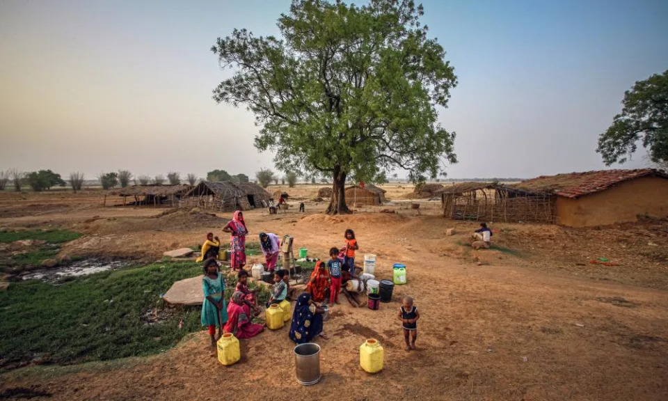
Photograph: Ritesh Shukla/Getty Images
The planet is being hit with a double whammy of global heating in 2023. On top of the inexorable rise in global temperature caused by greenhouse gas emissions is an emerging El Niño. This sporadic event is the biggest natural influence on year-to-year weather and adds a further spurt of warmth to an already overheating world. The result is supercharged extreme weather, hitting lives and livelihoods.
The last major El Niño from 2014 to 2016 led to each of those years successively breaking the global temperature record and 2016 remains the hottest year ever recorded. However, El Niño has now begun and may already be driving new temperature records, with record heatwaves on land from Puerto Rico to China and record heatwaves in the seas around the UK.
Fri, 23 June 2023
Photograph: Ritesh Shukla/Getty Images
The planet is being hit with a double whammy of global heating in 2023. On top of the inexorable rise in global temperature caused by greenhouse gas emissions is an emerging El Niño. This sporadic event is the biggest natural influence on year-to-year weather and adds a further spurt of warmth to an already overheating world. The result is supercharged extreme weather, hitting lives and livelihoods.
The last major El Niño from 2014 to 2016 led to each of those years successively breaking the global temperature record and 2016 remains the hottest year ever recorded. However, El Niño has now begun and may already be driving new temperature records, with record heatwaves on land from Puerto Rico to China and record heatwaves in the seas around the UK.
What is the El Niño-La Niña cycle?
Variations in wind strength and ocean temperatures in the vast Pacific Ocean lead to two distinct climate patterns, El Niño and La Niña. The switch between them happens irregularly, every three to seven years, usually with neutral years in between. El Niños tend to last about a year but the La Niña phase can be longer, and 2023 has brought the end of an unusual run of three successive La Niña years.
What drives the cycle?
Easterly winds normally push warm surface waters in the equatorial Pacific towards Australia and Indonesia and away from South America. As a result, warm water piles up in the west Pacific and cool water is drawn up from depth in the east Pacific. This is the neutral state.
But at the onset of El Niño, the easterly winds weaken and the warm water spreads back across the whole Pacific. In contrast, at the onset of La Niña, the easterly winds are even stronger than normal, leading to further cooling of the east Pacific waters.
The erratic timing of the switches between neutral, El Niño and La Niña conditions are the result of complex interactions between different climate system phenomena, from ocean current dynamics to thunderstorm cloud formation.
How does El Niño increase global temperatures?
The ocean absorbs more than 90% of the heat trapped by greenhouse gases released by fossil fuel burning and other human activities. The ocean is particularly effective at absorbing the heat during a La Niña event, when east Pacific temperatures are especially cold.
However, during an El Niño, some of this heat is released to the atmosphere because warm water is spread right across the Pacific, smothering cooler waters. El Niño can add up to 0.2C to annual global surface temperatures.
How does El Niño affect extreme weather?
The El Niño-La Niña cycle switches the position of warm ocean waters and the damp, rain-laden air above it, meaning the cycle brings increased heatwaves, droughts, wildfires and floods to different regions.
The places closest to the Pacific are most strongly affected. In Peru and Ecuador, El Niño brings heavy rains and flooding. The event’s full name – El Niño de Navidad, or the Christ Child – comes from the region and was coined because the biggest impacts occur at Christmas time.
In the Amazon, the weather gets hotter and drier during an El Niño, meaning less growth and greater risk of fires in a forest already approaching a tipping point. Heat and drought also increase in Colombia and Central America.
On the other side of the Pacific, Australia can be hit hard by the higher temperatures brought by El Niño. It raises the risk of heatwaves, drought, and bushfires in the east of the country and also increases the chances of mass coral bleaching of the Great Barrier Reef. The “black summer” of 2019-20 occurred during a small El Niño. Drought risk also increases in Indonesia and the last big El Niño from 2014-2016 fuelled huge forest fires, which sent a smoke plume halfway around the world.
Countries further from the equator are still significantly affected by El Niño, which shifts the position of the high-altitude jet stream wind. As a result, the southern US gets wetter weather and increased flood risks, while the northern US and Canada get warmer and drier. The situation is similar In China, wetter in the south and hotter and drier in the north.
Does El Niño affect places farther from the Pacific?
Yes – its impacts reverberate throughout the global climate system. Perhaps the biggest impact is a tendency for reduced rainfall in the Indian monsoon, which provides 70% of the country’s water and is vital for growing food in the world’s most populous nation. However, El Niño could bring increased rain to the drought-stricken Horn of Africa, where dry conditions brought by the three consecutive La Niñas exacerbated a long-term drought in parts of Ethiopia, Kenya and Somalia.
El Niño also affects the risk of hurricanes and typhoons, usually suppressing those that affect the Caribbean and US, India and Bangladesh, and Japan and Korea. However, these storms are powered by ocean heat, and record-high sea temperatures in the Atlantic in 2023 have led the UK Met Office to forecast an above-average number of tropical storms in the North Atlantic.
Europe is less affected, but in winter El Niño can shift the jet stream and bring more rain to the south of the continent and drier, colder conditions in the north.
El Niño’s impact on rainfall, temperature and plant growth also has knock-on effects, such as increased infectious disease including dengue fever in south-east Asia and Brazil. One study has even linked lower food production in El Niño years to civil wars.
What is the situation now?
Weak El Niño conditions arrived in May and are expected to strengthen in the coming months, with an 84% chance of a moderate event at its peak from November to January, and a 56% chance of a strong event.
Global average temperatures in early June were nearly 1C above levels previously recorded for the same month, leading to record heatwaves from Puerto Rico to Siberia to China. Some scientists said the heating suggested 2023 could become the hottest on record, although most of El Niño’s heat will appear in 2024.
Does human-caused climate change increase the likelihood of El Niño or La Niña, or both?
Scientists are not sure. This is partly because there are not very many El Niño and La Niña events in the observational record, which goes back about 150 years. That makes it hard to be sure that trends in the data, which suggest a tendency towards more La Niña events, are not simply the result of chance.
Furthermore, climate models do not agree on the question. This is because climate models have a relatively coarse resolution of 100km and cannot represent well either the ocean dynamics of the tropical Pacific or the thunderstorm clouds that drive large-scale circulation patterns. Prof Tim Palmer, at the University of Oxford, UK, hopes that a new generation of kilometre-scale global climate models, run on the latest “exascale” supercomputers, will provide more robust answers to this vitally important question.
One thing is certain. Rising global temperatures, boosted in El Niño years and bringing worse extreme weather, will not end until carbon emissions are reduced to net zero.
Here comes El Niño
The Week Staff
Sat, June 24, 2023
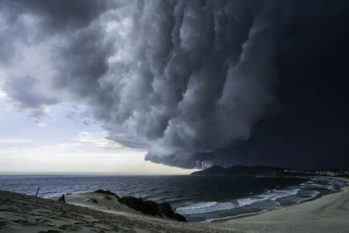
Storm moves in over coast. by wildestanimal/Getty Images.
Warming Pacific Ocean waters periodically unleash extreme weather around the globe, and climate change may make it worse. Here's everything you need to know:
What is El Niño?
It's a natural, cyclical warming of Pacific Ocean waters that makes global weather more extreme. The phenomenon was named back in the 1600s, when Peruvian fishermen noticed that waters sometimes warmed around Christmastime in the Eastern Pacific Ocean, affecting their catch and the weather. They named the phenomenon El Niño — "The Boy" — after the infant Jesus. The effects of an El Niño vary throughout the world: Some regions experience severe drought and wildfires, while others get massive downpours and flooding. The last full El Niño ended in 2016 — the hottest year on record. A new one was detected this month forming in the Pacific, and some meteorologists warn that this could be a "Super El Niño," dramatically raising global temperatures for a year or more.
Why would this one be stronger?
Global ocean temperatures already have smashed records in four of the past five years. The WMO predicts a 66% chance that this El Niño will temporarily raise global temperatures by roughly 0.7 degrees on top of previous warming of about 2 degrees, sending atmospheric temperatures zooming past the 2.7-degree Fahrenheit (1.5-degree Celsius) threshold established by the Paris climate agreement as a tipping point for more severe consequences. The World Meteorological Organization (WMO) is predicting that there is a 98% likelihood that at least one of the next five years, and the five-year period as a whole, will be the warmest on record. "We're in unprecedented territory," said Michelle L'Heureux, a meteorologist with the National Oceanic and Atmospheric Administration's Climate Prediction Center.
How does an El Niño form?
In the Eastern Pacific, near the equator, trade winds usually flow from east to west, pushing warm surface water toward Australia and Asia and letting cooler water rise to the surface near the Americas. For reasons scientists don't fully understand, during an El Niño period, those winds tend to die down or reverse, allowing the warm surface water to flow eastward and preventing cold water from rising. The moisture of the warm water evaporates into the atmosphere, causing the global temperature to rise, currents to shift, and local weather systems to depart from their usual patterns. Forecasters generally wait until sea surface temperatures rise 0.9 degrees Fahrenheit for at least three months before declaring an El Niño's arrival, which usually occurs every two to seven years.
What happens then?
El Niño usually strikes first in the Southern Hemisphere from July to September (their winter). North America then experiences the impact from December through January. In the southeastern third of the U.S., that often means downpours, flooding, and landslides. But areas further north in the Americas tend to see warmer, drier conditions, which create prime conditions for wildfires such as the 400-plus blazes now burning across Canada. The 1997-98 El Niño caused an estimated 23,000 deaths. El Niño-fueled fires in Southeast Asia alone contributed to as many as 100,000 deaths in 2015 and 2016. Dartmouth researchers recently estimated that each El Niño saps an average of $3.4 trillion from the global economy, destroying crops and preventing the flow of goods and services.
What can we expect from this El Niño?
Scientists can only guess, because it arrives to a changed world. We've just seen the end of an abnormally long La Niña — a countervailing phenomenon in which strong Pacific trade winds periodically increase the upwelling of cold, deep water, producing many of the opposite effects of an El Niño. That La Niña began in 2020 and lasted for most of the past three years before ending in March — but its normal cooling effect did not materialize. Instead, ocean temperatures continued rising, and 2020, 2021 and 2022 remained hotter than any El Niño year before 2015. Though the U.S. is usually given a reprieve from strong, frequent Atlantic and Caribbean hurricanes during El Niños, that's not expected to be the case this time.
Why not?
The world's oceans have absorbed more than 90% of the warmth generated by fossil fuels. As a result, North Atlantic temperatures — which reached nearly 73 degrees this month — are now higher than at "any day in recorded history," according to UCLA climatologist Daniel Swain. The Pacific also appears to be warming in a lasting way. Warm waters make for frequent and powerful hurricanes and cyclones, and forecasters expect an above-average season this year. Marine heat waves also speed up the melting of ice sheets and kill off fish stocks and wildlife. The severe warming of the 2015-16 El Niño destroyed nearly a third of the coral in the Great Barrier Reef. A recent Australian study suggests El Niño/La Niña temperature shocks have grown 10% more extreme since 1960. The double whammy of this El Niño on top of climate change, scientists warn, could trigger weather extremes and disasters of unprecedented scope and scale. "There's a huge amount of heat stored below the surface that's ready to erupt," said NOAA senior scientist Michael McPhaden. "The escalator is only going up."
Peru as ground zero
The cyclical pattern of current and weather changes Peruvian fisherman named El Niño actually dates back thousands of years, at least to the last Ice Age, geological research has determined. The phenomenon may have even played a role in the collapse of ancient civilizations such as the Inca. Every region in the world is affected differently by El Niños; for Peru, they usually bring a major increase in rainfall and storms. Over recent decades, the country has been severely battered during El Niño, with whole villages sliding off sodden mountainsides. In 2017, heavy rain and flooding displaced some 300,000 Peruvians. And this year's El Niño is already being blamed for downpours and a consequential outbreak of mosquito-borne dengue fever that has sickened nearly 140,000 people. "The increase in temperature is going to continue, and diseases like dengue are one of the results," said Dr. Luis Pampa of Peru's National Health Institute. "We don't have to be fortune tellers to say that, if we do not not take this problem seriously, it could get worse."
This article was first published in the latest issue of The Week magazine. If you want to read more like it, you can try six risk-free issues of the magazine here.
The Week Staff
Sat, June 24, 2023
Storm moves in over coast. by wildestanimal/Getty Images.
Warming Pacific Ocean waters periodically unleash extreme weather around the globe, and climate change may make it worse. Here's everything you need to know:
What is El Niño?
It's a natural, cyclical warming of Pacific Ocean waters that makes global weather more extreme. The phenomenon was named back in the 1600s, when Peruvian fishermen noticed that waters sometimes warmed around Christmastime in the Eastern Pacific Ocean, affecting their catch and the weather. They named the phenomenon El Niño — "The Boy" — after the infant Jesus. The effects of an El Niño vary throughout the world: Some regions experience severe drought and wildfires, while others get massive downpours and flooding. The last full El Niño ended in 2016 — the hottest year on record. A new one was detected this month forming in the Pacific, and some meteorologists warn that this could be a "Super El Niño," dramatically raising global temperatures for a year or more.
Why would this one be stronger?
Global ocean temperatures already have smashed records in four of the past five years. The WMO predicts a 66% chance that this El Niño will temporarily raise global temperatures by roughly 0.7 degrees on top of previous warming of about 2 degrees, sending atmospheric temperatures zooming past the 2.7-degree Fahrenheit (1.5-degree Celsius) threshold established by the Paris climate agreement as a tipping point for more severe consequences. The World Meteorological Organization (WMO) is predicting that there is a 98% likelihood that at least one of the next five years, and the five-year period as a whole, will be the warmest on record. "We're in unprecedented territory," said Michelle L'Heureux, a meteorologist with the National Oceanic and Atmospheric Administration's Climate Prediction Center.
How does an El Niño form?
In the Eastern Pacific, near the equator, trade winds usually flow from east to west, pushing warm surface water toward Australia and Asia and letting cooler water rise to the surface near the Americas. For reasons scientists don't fully understand, during an El Niño period, those winds tend to die down or reverse, allowing the warm surface water to flow eastward and preventing cold water from rising. The moisture of the warm water evaporates into the atmosphere, causing the global temperature to rise, currents to shift, and local weather systems to depart from their usual patterns. Forecasters generally wait until sea surface temperatures rise 0.9 degrees Fahrenheit for at least three months before declaring an El Niño's arrival, which usually occurs every two to seven years.
What happens then?
El Niño usually strikes first in the Southern Hemisphere from July to September (their winter). North America then experiences the impact from December through January. In the southeastern third of the U.S., that often means downpours, flooding, and landslides. But areas further north in the Americas tend to see warmer, drier conditions, which create prime conditions for wildfires such as the 400-plus blazes now burning across Canada. The 1997-98 El Niño caused an estimated 23,000 deaths. El Niño-fueled fires in Southeast Asia alone contributed to as many as 100,000 deaths in 2015 and 2016. Dartmouth researchers recently estimated that each El Niño saps an average of $3.4 trillion from the global economy, destroying crops and preventing the flow of goods and services.
What can we expect from this El Niño?
Scientists can only guess, because it arrives to a changed world. We've just seen the end of an abnormally long La Niña — a countervailing phenomenon in which strong Pacific trade winds periodically increase the upwelling of cold, deep water, producing many of the opposite effects of an El Niño. That La Niña began in 2020 and lasted for most of the past three years before ending in March — but its normal cooling effect did not materialize. Instead, ocean temperatures continued rising, and 2020, 2021 and 2022 remained hotter than any El Niño year before 2015. Though the U.S. is usually given a reprieve from strong, frequent Atlantic and Caribbean hurricanes during El Niños, that's not expected to be the case this time.
Why not?
The world's oceans have absorbed more than 90% of the warmth generated by fossil fuels. As a result, North Atlantic temperatures — which reached nearly 73 degrees this month — are now higher than at "any day in recorded history," according to UCLA climatologist Daniel Swain. The Pacific also appears to be warming in a lasting way. Warm waters make for frequent and powerful hurricanes and cyclones, and forecasters expect an above-average season this year. Marine heat waves also speed up the melting of ice sheets and kill off fish stocks and wildlife. The severe warming of the 2015-16 El Niño destroyed nearly a third of the coral in the Great Barrier Reef. A recent Australian study suggests El Niño/La Niña temperature shocks have grown 10% more extreme since 1960. The double whammy of this El Niño on top of climate change, scientists warn, could trigger weather extremes and disasters of unprecedented scope and scale. "There's a huge amount of heat stored below the surface that's ready to erupt," said NOAA senior scientist Michael McPhaden. "The escalator is only going up."
Peru as ground zero
The cyclical pattern of current and weather changes Peruvian fisherman named El Niño actually dates back thousands of years, at least to the last Ice Age, geological research has determined. The phenomenon may have even played a role in the collapse of ancient civilizations such as the Inca. Every region in the world is affected differently by El Niños; for Peru, they usually bring a major increase in rainfall and storms. Over recent decades, the country has been severely battered during El Niño, with whole villages sliding off sodden mountainsides. In 2017, heavy rain and flooding displaced some 300,000 Peruvians. And this year's El Niño is already being blamed for downpours and a consequential outbreak of mosquito-borne dengue fever that has sickened nearly 140,000 people. "The increase in temperature is going to continue, and diseases like dengue are one of the results," said Dr. Luis Pampa of Peru's National Health Institute. "We don't have to be fortune tellers to say that, if we do not not take this problem seriously, it could get worse."
This article was first published in the latest issue of The Week magazine. If you want to read more like it, you can try six risk-free issues of the magazine here.
No comments:
Post a Comment