A possible explanation for an increasing trend in the cyclone Genesis Potential Index in the Arabian Sea

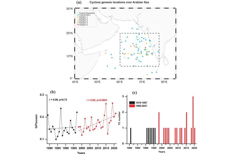
A team of Earth scientists and oceanographers affiliated with several institutions in India, working with a colleague from the U.S., has developed possible explanations for some of the factors involved in the observed increasing trend in the cyclone Genesis Potential Index (GPI) in the Arabian Sea.
In their study, reported in the journal npj Climate and Atmospheric Science, the group used data from multiple other studies to learn more about the drivers of cyclonic GPI in the Arabian Sea.
Prior research has suggested that climate change is going to have a major impact on weather around the world. Much effort has gone into studying such changes but they are still difficult to predict. One change already occurring is a reduction in the amount of monsoon rainfall over the Indian subcontinent over the past several decades.
The region has also seen an increase in extreme rainfall events, changes in heat waves and droughts and the number of cyclones that come ashore. Prior research has also shown a dramatic change in the potential for cyclone formation over the Arabian Sea during roughly the same time period.
As the researchers note, it is easy to pin such changes on climate change—much more difficult is to explain just what is happening as the climate changes at a more local level. In this new effort, the research team sought to find all of the factors, or as many as possible, that lead to an increase in cyclonic GPI in the Arabian Sea.
They note that prior research has shown that the factors that lead to changes in GPI in general are related to changes in water temperature, how much heat the ocean is holding, and changes in wind, including rotation near the sea surface. This, they suggest, indicates that one or more of these factors must be responsible for the GPI change in the Arabian Sea.
The team found that over the past 30 years, all such drivers (except wind rotation) would seem to favor an increase in cyclone formation. That led them to ask why that is. They found a shift in the "warm Arctic, cold Eurasian" pattern—a pattern of warm sea surface temperatures over the Arctic Ocean that have been associated with a mass of cold sea surface temperatures over Eurasia. The pattern is believed to be connected to the circulation of upper air over the entire region.
As to why such changes there have occurred, the team cannot say, other than to suggest that it is likely tied to global warming.
More information: P. J. Vidya et al, Intensification of Arabian Sea cyclone genesis potential and its association with Warm Arctic Cold Eurasia pattern, npj Climate and Atmospheric Science (2023). DOI: 10.1038/s41612-023-00476-2
No comments:
Post a Comment