Mapping the world's oceans — a blessing or a curse?
International researchers have so far mapped just one-fifth of the mysterious ocean floor

Looking at Google Maps, it may seem as if every last corner of the planet has already been subjected to topographical surveys. But what lies beneath the ocean surface remains largely hidden from the view of orbiting satellites.
That's because radar signals can't penetrate water. So while commercial satellites provide a resolution of about 30 centimeters per pixel of the Earth's surface, ocean images are much rougher, with a resolution of around just 5 to 8 kilometers (3-5 miles) per pixel.
Only about 20% of the ocean floor has been surveyed so far with echo sounding. But Seabed 2030, a joint project between the United Nations and the private Nippon Foundation, aims to map the entire ocean floor by the end of this decade.
Ocean depths hold 'entire worlds'
"The ocean covers 71% of the planet, so it's just vast, incomprehensibly vast," said Laura Trethewey, a Canadian environmental journalist and author of "The Deepest Map: The High-Stakes Race to Chart the World's Oceans," published in 2023.
"There's just no terrestrial equivalent, which is why we so often compare the ocean to the moon or outer space. There's nowhere else on land that comes close to the ocean in terms of size," she added, pointing out that both the moon and Mars have been more thoroughly mapped than the ocean floor.
"We stretch for the stars and dream of building new perfect societies on Mars. But I would point out that we have this otherworldly space right here on Earth that we haven't finished exploring yet."

To explore the underwater universe, acoustic sound waves are emitted in a fan-like pattern from ships, diving robots and submarines in various directions toward the seafloor. The time it takes for these signals to travel to the bottom and back is measured individually for each sound wave, from which the depth is calculated. The deeper the sound, the deeper the sea.
Surveying with multibeam echo sounding provides topographic maps, three-dimensional models and terrain profiles even for very great depths. "There are entire worlds that we're missing out on right here on Earth — undiscovered mountains and canyons, animals unknown to science and just huge amounts of data and discoveries that are still out there waiting for us," said Trethewey.
In light of climate change, researching the seabed could also provide important information about what the future could hold.
"A lot of the seafloor used to be land. After the last ice age, melting glaciers released water that covered continental shelves that are equal to the size of South America. So there's a whole other continent down there, another lost Atlantis, that could hold insight into how past human societies navigated sea level rise and what we might do facing the same problem in the future," said Trethewey.
"Making the map is the first step in making that future a reality."
An ambitious project
Seabed 2030 will likely fall short of its ambitious goal, however. The oceans are simply too large and the ships and sonar equipment needed are lacking — not to mention the delays due to the COVID-19 pandemic and a waning political motivation.
"Back when the project launched in 2017, the world was a less fractured place, geopolitically. We live in a more unstable time now and governments are more suspicious and less willing to share maps," said Trethewey, adding that technology isn't the issue as it has existed for decades.
Organizers have tried in vain to "make up for any shortfalls with innovations like drones and crowdsourcing and recruiting super yachts and cruise ships to map the seafloor," she said.
Major 'push to exploit the deep sea'
But the fact remains that deep-sea exploration poses an extreme challenge for both humans and equipment. Adverse conditions at sea require expedition costs of around $50,000 (€43,000) a day, said Trethewey, "which means governments and businesses often need a good incentive to map, usually for resources, infrastructure or national security interests."
Seabed 2030 has estimated that the cost of reaching its goal will be between $3 billion and $4 billion (€2.5 billion to €3.4 billion) —roughly equivalent to the NASA Mars mission that began in 2020 and included landing a rover on the planet.
One downside of success could be that more complete mapping would significantly accelerate the exploitation of the oceans, however. "When people think of maps, they often think of mining and resource extraction. And they're not wrong. Right now there’s a big push to exploit the deep sea and open the first commercial mines in international waters," said Trethewey.
But she hopes that mapping will be used primarily for science and conservation, as the international community agreed to do after the complete mapping of Antarctica with the Antarctic Treaty in 1959, which protected the continent for scientific purposes for 60 years.
Still, strict regulations are unlikely to protect the deep sea as effectively as ignorance and inaccessibility.
"Nearly two-thirds of the ocean and almost half the surface of the planet fall in what's called international waters, so no country or person has ownership rights over it. This unclear legal status is the major reason why the international ocean is mostly unmonitored and unregulated, and why it's so hard to tackle crime at sea, whether it's overfishing or pollution or drug trafficking," said Trethewey.
"Stricter ocean governance would be welcome, but what’s perhaps more important are money and political will," she added. "The ocean is vast, incomprehensibly vast [...] and without money to fund monitoring and enforcement at sea, more rules are largely meaningless."
This article was originally written in German.

Alexander Freund Science editor with a focus on archaeology, history and health@AlexxxFreund
U.S. Oceanography Cornerstone Research Vessel Retires After 50 Yar
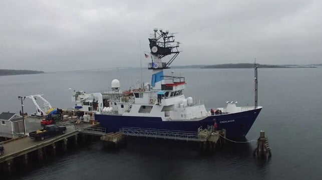
A research vessel that has been the cornerstone of ocean science in the U.S. for five decades is set to retire, marking an end to an illustrious career. The R/V Endeavor, which has been synonymous with ocean research in the modern era, will retire on September 20 upon the completion of its final mission.
Two weeks ago, Endeavor embarked on its final mission, which was focused on the long-term impacts of oil and gas extraction on ecosystems along the Atlantic coast, including historical, active, and future production areas. On September 20, the vessel will return to its home port at the University of Rhode Island’s (URI) Bay Campus in Narragansett, ending a long career in ocean science.
First launched in 1975, the ship is owned by the National Science Foundation (NSF) and operated by URI’s Graduate School of Oceanography (GSO) under a charter party agreement. Endeavor was one of three intermediate-class research vessels commissioned by NSF and built by Peterson Builders, in Sturgeon Bay, Wisconsin.
At 185 feet (56 meters) and officially christened at the GSO pier on December 11, 1976, the vessel was designed from the keel up for oceanographic work, a floating laboratory built to advance exploration and discovery. Nuala Pell, the wife of Senator Claiborne Pell, broke the traditional bottle of champagne across the bow.
Based out of Narragansett, Endeavor has lived up to its billing as the cornerstone of oceanography in the U.S., spending approximately 200 days a year at sea for five decades. Her illustrious career is unrivalled. She brought on board over 8,000 scientists, engineers, technicians, students, and teachers who spent 9,600 days at sea carrying out a total of 736 scientific expeditions. Over her long career, Endeavor sailed over one million miles and made port calls in 22 countries.
The longest expedition for the ship with a capacity of 16 scientists, 12 crewmembers, and two marine technicians was 38 days, while the deepest instrument deployment was at a depth of 8,700 meters.
Endeavor’s career started through baptism by fire. Only four days after her christening, she found herself responding to one of the largest oil spills in U.S. history after tanker Argo Merchant ran aground off Nantucket Island during a storm on December 15, 1976. The tanker was carrying more than 7.7 million gallons of heavy fuel oil that spilled into the ocean after the tanker broke apart.
The disaster thrust Endeavor on her first mission studying the movement of currents, analyzing the spread of oil hydrocarbons, and assessing the impact on marine ecosystems. The series of trips to the spill site lasted three months and is considered by the National Oceanic and Atmospheric Administration to be the birth of oil spill response.
Apart from the spill response, the ship has also been instrumental in the advancement of the oil and gas industry. Owing to her proximity to the Gulf Stream, the vessel has led a number of missions, particularly during the 1980s and 1990s, focusing on circulation and biogeochemistry studies.
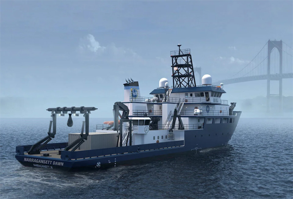
Narragansett Dawn, now under construction, will start sailing in 2027 as the new research vessel (URI)
A key milestone for Endeavor’s history was in 1993 when she underwent a major mid-life refit that saw her length increased from 177 feet to her current overall length of 185 feet (56 meters). After that, she would go on to carry out other critical missions like responding to the devastating 2010 Haiti earthquake, delivering humanitarian aid, and undertaking post-earthquake seafloor surveys. The same year, she was involved in the Deepwater Horizon oil spill response in the Gulf of Mexico.
Following the retirement of Endeavor, URI is preparing to welcome a new research vessel at its Narragansett Bay Campus pier. The $125 million vessel, which is also owned by NSF and has been named Narragansett Dawn, will arrive in 2027. The 199-foot (61-meter) ship is being constructed at the Bollinger Houma Shipyards in Houma, Louisiana.
Sen
No comments:
Post a Comment