'MRI' scan reveals spectacular ice age landscapes beneath the North Sea

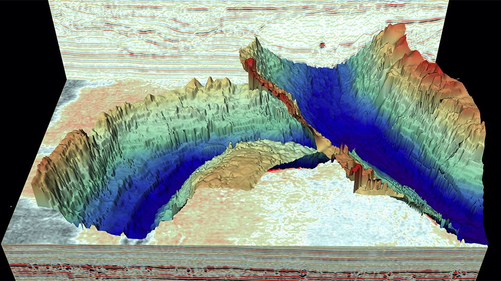
Spectacular ice age landscapes beneath the North Sea have been discovered using 3D seismic reflection technology. Similar to MRI (magnetic resonance imaging) the images reveal in unprecedented detail huge seafloor channels—each one 10 times wider than the River Thames.
For the first time an international team of scientists can show previously undetectable landscapes that formed beneath the vast ice sheets that covered much of the UK and Western Europe thousands to millions of years ago. These ancient structures provide clues to how ice sheets react to a warming climate. The findings are published this week in the journal Geology.
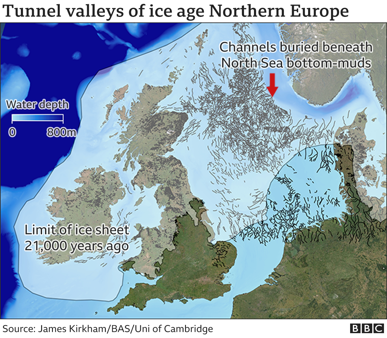
So called tunnel valleys, buried hundreds of meters beneath the seafloor in the North Sea are remnants of huge rivers that were the 'plumbing system' of the ancient ice sheets as they melted in response to rising air temperatures.
Lead author James Kirkham, from British Antarctic Survey (BAS) and the University of Cambridge, says:
"The origin of these channels was unresolved for over a century. This discovery will help us better understand the ongoing retreat of present-day glaciers in Antarctica and Greenland.
"In the way that we can leave footprints in the sand, glaciers leave an imprint on the land upon which they flow. Our new cutting edge data gives us important markers of deglaciation. "
Dr. Kelly Hogan, co-author and a geophysicist at BAS, says:
"Although we have known about the huge glacial channels in the North Sea for some time, this is the first time we have imaged fine-scale landforms within them. These delicate features tell us about how water moved through the channels (beneath the ice) and even how ice simply stagnated and melted away. It is very difficult to observe what goes on underneath our large ice sheets today, particularly how moving water and sediment is affecting ice flow and we know that these are important controls on ice behavior. As a result, using these ancient channels to understand how ice will respond to changing conditions in a warming climate is extremely relevant and timely."
3D seismic reflection technology, which was provided by industry partners, uses sound waves to generate detailed three-dimensional representations of ancient landscapes buried deep beneath the surface of the Earth, in a similar manner to how magnetic resonance imaging (MRI) scans can image structures within the human body. The method can image features as small as a few meters beneath the surface of the Earth, even if they are buried under hundreds of meters of sediment. The exceptional detail provided by this new data reveals the imprint of how the ice interacted with the channels as they formed. By comparing these ancient 'ice fingerprints' to those left beneath modern glaciers, the scientists were able to reconstruct how these ancient ice sheets behaved as they receded.
By diving into the past, this work provides a window into a future warmer world where new processes may begin to alter the plumbing system and flow behavior of the Antarctic and Greenland ice sheets.
"Tunnel valley infill and genesis revealed by high‑resolution 3D seismic data" is published in the journal Geology.
Jonathan Amos
Science correspondent
@BBCAmoson Twitter
Published1 day ago
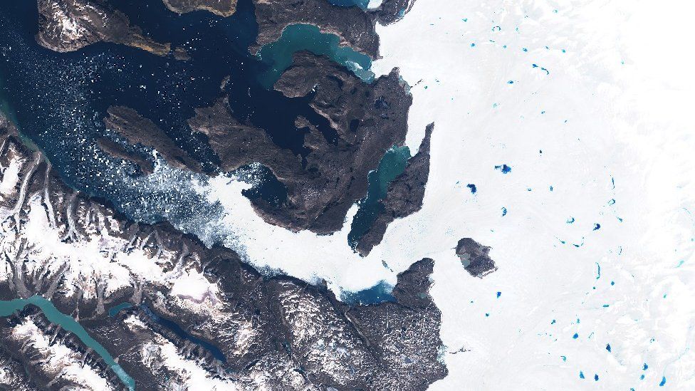
Spectacular ice age landscapes have been revealed beneath the North Sea.
These deep, kilometres-wide channels, known as tunnel valleys, were cut by fast-flowing rivers that ran under Northern Europe's ancient ice sheets.
Today, the landforms are all hidden by the North Sea's bottom-muds, but new survey work has traced their outline in remarkable 3D detail.
Scientists say the channels should give us clues as to how modern-day ice sheets, such as Greenland, will decay.
That's because these features were all incised during periods of great melt.
"These tunnel valleys were formed during the death throes of an ice sheet in extremely warm climates," said James Kirkham, from the British Antarctic Survey (BAS) and Cambridge University.
"This makes them a great analogue for what Greenland, or even Antarctica, might begin to look like in the future, perhaps several 100 years down the line," he told BBC News.
IPCC report is 'code red for humanity'
Greenland and Antarctica ice loss accelerating
Underwater avalanche continued for two days
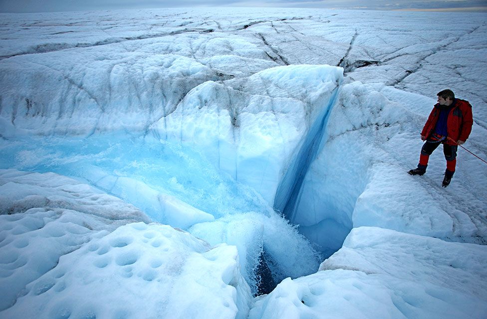
Today, if you visit Greenland during summer months, you'll see huge lakes of meltwater pooling on the ice sheet's surface.
This water funnels down holes to reach the bed, where it then spreads out and drains to the sea. But as it does so, this water also lubricates the flow of the ice sheet above.
Researchers have used all manner of sensors to try to understand the sub-glacial processes involved. The US space agency Nasa even sent an armada of bath-time rubber ducks on a mission to see if they could traverse Greenland's under-ice rivers.
The landforms described by Mr Kirkham and colleagues in the journal Geology provide this information in a different way - at huge scale and with super-fine resolution.
This is made possible by new seismic (sound wave) survey techniques that ordinarily would be used to image the structure of sea-floor sediments to see that they're suitable to host oil and gas, or renewables, infrastructure. But scientists can exploit that same data to recall the glacial history of the North Sea.
The past 800,000 years have seen repeated incursions of thick ice over Northern Europe during cold periods, to be followed by mass retreat when temperatures rose again. It was during the very warm phases that the tunnel valleys were cut.
James Kirkham's team describes a complex network of incisions and deposits that were made both by the rivers and by the movement of the ice on top.
These landforms include so-called eskers where water has cut a recess in the ice above which then gets filled with mud to preserve a mound - a bit like a jelly mould.
There are long sinuous ridges where sediments got squeezed into the fractures that developed in fast-flowing ice that suddenly came to a stop.
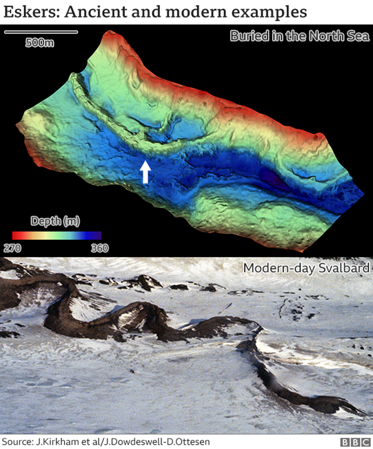
And there are even "fossil icebergs", more properly called kettle holes. These are where chunks of ice broke off the edge of a retreating sheet, got stuck in mud and then, as the blocks melted away, created voids that were later filled with a different kind of sediment to the surroundings.
"These patterns we see in the seismic data show us what the sub-glacial rivers were doing over many years, centuries even, as the ice was retreating," explained BAS co-author Dr Kelly Hogan. "And they also show us how that ice on top was behaving. We can see where it was moving quickly or where it had simply stagnated and melted away," she told BBC News.
"This is all information we need to properly model modern ice sheets, to try to understand what Greenland and Antarctica might look like in the future."
The recent state-of-the-climate report from the UN's Intergovernmental Panel on Climate Change (IPCC) said surface melting of Greenland as a result of increased air temperatures would dominate the territory's ice losses this century.
This will boost the flow of water to the sub-glacial "plumbing system" that produces the kinds of features recorded in the North Sea sediments.
Antarctica is a little different. Ice losses in the polar south are driven largely by incursions of warm ocean waters at the ice sheet's margins. Warmer air causing melting at the surface is evident in a few places but is less of a factor.
No comments:
Post a Comment