Tuesday, June 07, 2022

Growing wildfire threats loom over the birthplace of the atomic bomb

Los Alamos National Laboratory says it’s prepared, but an audit in 2021 suggests it’s not


By James R. Riordon
Guest Writer
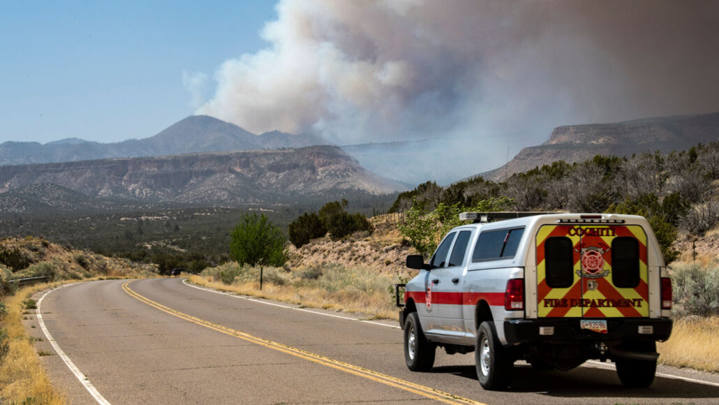
At one point, the Cerro Pelado fire in New Mexico came within about six kilometers of Los Alamos National Laboratory, the birthplace of the atomic bomb. Here, smoke from the fire is seen on April 29
.
ROBERT BROWMAN/THE ALBUQUERQUE JOURNAL VIA AP

There are things I will always remember from my time in New Mexico. The way the bark of towering ponderosa pines smells of vanilla when you lean in close. Sweeping vistas, from forested mountaintops to the Rio Grande Valley, that embellish even the most mundane shopping trip. The trepidation that comes with the tendrils of smoke rising over nearby canyons and ridges during the dry, wildfire-prone summer months.

There were no major wildfires near Los Alamos National Laboratory during the year and a half that I worked in public communications there and lived just across Los Alamos Canyon from the lab. I’m in Maryland now, and social media this year has brought me images and video clips of the wildfires that have been devastating parts of New Mexico, including the Cerro Pelado fire in the Jemez Mountains just west of the lab.

Wherever they pop up, wildfires can ravage the land, destroy property and displace residents by the tens of thousands. The Cerro Pelado fire is small compared with others raging east of Santa Fe — it grew only to the size of Washington, D.C. The fire, which started mysteriously on April 22, is now mostly contained. But at one point it came within 5.6 kilometers of the lab, seriously threatening the place that’s responsible for creating and maintaining key portions of fusion bombs in our nation’s nuclear arsenal.

That close call may be just a hint of growing fire risks to come for the weapons lab as the Southwest suffers in the grip of an epic drought made worse by human-caused climate change (SN: 4/16/20). May and June typically mark the start of the state’s wildfire season. This year, fires erupted in April and were amplified by a string of warm, dry and windy days. The Hermits Peak and Calf Canyon fires east of Santa Fe have merged to become the largest wildfire in New Mexico’s recorded history.

Los Alamos National Lab is in northern New Mexico, about 56 kilometers northwest of Santa Fe. The lab’s primary efforts revolve around nuclear weapons, accounting for 71 percent of its $3.9 billion budget, according the lab’s fiscal year 2021 numbers. The budget covers a ramp-up in production of hollow plutonium spheres, known as “pits” because they are the cores of nuclear bombs, to 30 per year beginning in 2026. That’s triple the lab’s current capability of 10 pits per year. The site is also home to radioactive waste and debris that has been a consequence of weapons production since the first atomic bomb was built in Los Alamos in the early 1940s (SN: 8/6/20).

What is the danger due to fire approaching the lab’s nuclear material and waste? According to literature that Peter Hyde, a spokesperson for the lab, sent to me to ease my concern, not much.

Over the last 3½ years, the lab has removed 3,500 tons of trees and other potential wildfire fuel from the sprawling, 93-square-kilometer complex. Lab facilities, a lab pamphlet says, “are designed and operated to protect the materials that are inside, and radiological and other potentially hazardous materials are stored in containers that are engineered and tested to withstand extreme environments, including heat from fire.”

What’s more, most of roughly 20,000 drums full of nuclear waste that were stored under tents on the lab’s grounds have been removed. They were a cause for anxiety during the last major fire to threaten the lab in 2011. According to the most recent numbers on the project’s website, all but 3,812 of those drums have been shipped off to be stored 655 meters underground at the Waste Isolation Pilot Plant near Carlsbad, N.M.

But there’s still 3,500 cubic meters of nuclear waste in the storage area, according to a March 2022 DOE strategic planning document for Los Alamos. That’s enough to fill 17,000 55-gallon drums. So potentially disastrous quantities of relatively exposed nuclear waste remain at the lab — a single drum from the lab site that exploded after transport to Carlsbad in 2014 resulted in a two-year shutdown of the storage facility. With a total budgeted cleanup cost of $2 billion, the incident is one of the most expensive nuclear accidents in the nation’s history.

Since the 2011 fire, a wider buffer space around the tents has been cleared of vegetation. In conjunction with fire suppression systems, it’s unlikely that wildfire will be a danger to the waste-filled drums, according to a 2016 risk analysis of extreme wildfire scenarios conducted by the lab.

But a February 2021 audit by the U.S. Department of Energy’s Office of Inspector General is less rosy. It found that, despite the removal of most of the waste drums and the multiyear wildfire mitigation efforts that the lab describes, the lab’s wildfire protection is still lacking.

According to the 20-page federal audit, the lab at that time had not developed a “comprehensive, risk-based approach to wildland fire management” in accordance with federal policies related to wildland fire management. The report also noted compounding issues, including the absence of federal oversight of the lab’s wildfire management activities.
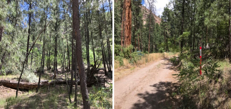
A canyon on lab grounds that runs alongside the adjacent city of Los Alamos (two spots shown) was called out in an audit by the Department of Energy’s Office of Inspector General because it was packed with about 400 to 500 trees per acre. The ideal number from a wildfire management viewpoint is 40 to 50 trees per acre.
THE DEPARTMENT OF ENERGY’S WILDLAND FIRE PREVENTION EFFORTS AT THE LOS ALAMOS NATIONAL LABORATORY

Among the ongoing risks, not all fire roads were maintained well enough to provide a safe route for firefighters and others, “which could create dangerous conditions for emergency responders and delay response times,” the auditors wrote.

And a canyon that runs between the lab and the adjacent town of Los Alamos was identified in the report as being packed with 10 times the number of trees that would be ideal, from a wildfire safety perspective. To make matters worse, there’s a hazardous waste site at the bottom of the canyon that could, the auditors wrote, “produce a health risk to the environment and to human health during a fire.”

“The report was pretty stark,” says Edwin Lyman, director of nuclear power safety at the Union of Concerned Scientists. “And certainly, after all the warnings, if they’re still not doing all they need to do to fully mitigate the risk, then that’s just foolishness.”

A 2007 federal audit of Los Alamos, as well as nuclear weapons facilities in Washington state and Idaho, showed similar problems. In short, it seems little has changed at Los Alamos in the 14-year span between 2007 and 2021. Lab spokespeople did not respond to my questions about the lab’s efforts to address the specific problems identified in the 2021 report, despite repeated requests.

The Los Alamos area has experienced three major wildfires since the lab was founded — the Cerro Grande fire in 2000, Las Conchas in 2011 and Cerro Pelado this year. But we probably can’t count on 11-year gaps between future wildfires near Los Alamos, according to Alice Hill, the senior fellow for energy and the environment with the Council on Foreign Relations, who’s based in Washington, D.C.

The changing climate is expected to dramatically affect wildfire risks in years to come, turning Los Alamos and surrounding areas into a tinderbox. A study in 2018 in Climatic Change found that the region extending from the higher elevations in New Mexico, where Los Alamos is located, into Colorado and Arizona will experience the greatest increase in wildfire probabilities in the Southwest. A new risk projection tool that was recommended by Hill, called Risk Factor, also shows increasing fire risk in the Los Alamos area over the next 30 years.

“We are at the point where we are imagining, as we have to, things that we’ve never experienced,” Hill says. “That is fundamentally different than how we have approached these problems throughout human history, which is to look to the past to figure out how to be safer in the future…. The nature of wildfire has changed as more heat is added [to the planet], as temperatures rise.”

Increased plutonium pit production will add to the waste that needs to be shipped to Carlsbad. “Certainly, the radiological assessments in sort of the worst case of wildfire could lead to a pretty significant release of radioactivity, not only affecting the workers onsite but also the offsite public. It’s troubling,” says Lyman, who suggests that nuclear labs like Los Alamos should not be located in such fire-prone areas.
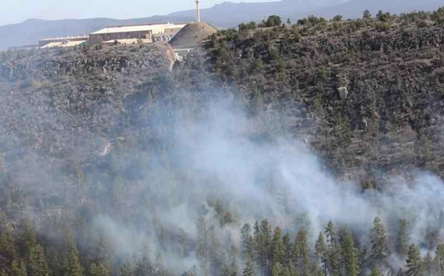
The Los Alamos Neutron Science Center (shown in March of 2019), a key facility at Los Alamos National Laboratory, was evacuated in March 2019 when power lines sparked a nearby wildfire. It could be damaged or even destroyed if a high-intensity wildfire burned through a nearby heavily forested canyon, according to an audit by the Department of Energy’s Office of Inspector General.
THE DEPARTMENT OF ENERGY’S WILDLAND FIRE PREVENTION EFFORTS AT THE LOS ALAMOS NATIONAL LABORATORY

For now, some risks from the Cerra Pelado wildfire will persist, according to Jeff Surber, operations section chief for the U.S. Department of Agriculture Forestry Service’s efforts to fight the fire. Large wildfires like Cerra Pelado “hold heat for so long and they continue to smolder in the interior where it burns intermittently,” he said in a May 9 briefing to Los Alamos County residents, and to concerned people like me watching online.

It will be vital to monitor the footprint of the fire until rain or snow finally snuffs it out late in the year. Even then, some danger will linger in the form of “zombie fires” that can flame up long after wildfires appear to have been extinguished (SN: 5/19/21). “We’ve had fires come back in the springtime because there was a root underground that somehow stayed lit all winter long,” said Surber.

So the Cerro Pelado fire, and its occasional smoky tendrils, will probably be a part of life in northern New Mexico for months still. And the future seems just as fiery, if not worse. That’s something all residents, including the lab, need to be preparing for.

Meantime, if you make it out to the mountains of New Mexico soon enough, be sure to sniff a vanilla-flavored ponderosa while you still can. I know I will.
 James R. Riord is a freelance science writer who covers physics, math, astronomy and occasional lifestyle stories.
Ancient zircons offer insights into earthquakes of the past

New research could improve understanding of how today’s tremors release energy


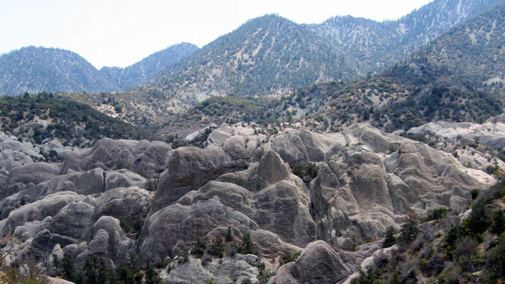
These rocks at the Devil’s Punchbowl geologic formation near Los Angeles were uplifted by movement along the Punchbowl Fault, a now-inactive portion of the larger San Andreas Fault.
NYARTSNWORDS/WIKIMEDIA COMMONS


By Nikk Ogasa

Earthquakes have rocked the planet for eons. Studying the quakes of old could help scientists better understand modern tremors, but tools to do such work are scarce.

Enter zircons. Researchers used the gemstones to home in on the temperatures reached within a fault during earthquakes millions of years ago. The method offers insights into the intensity of long-ago quakes, and could improve understanding of how today’s tremors release energy, the researchers report in the April Geochemistry, Geophysics, Geosystems.

“The more we understand about the past, the more we can understand what might happen in the future,” says Emma Armstrong, a thermochronologist at Utah State University in Logan.

Armstrong and colleagues focused on California’s Punchbowl Fault. That now-quiet portion of the larger San Andreas Fault was probably active between 1 million to 10 million years ago, Armstrong says.

Heat from friction is generated in a fault when it slips and triggers an earthquake. Previous analyses of preserved organic material suggested that temperatures within the Punchbowl Fault peaked between 465° Celsius and 1065° C. The researchers suspected that zircons in rocks from the fault could narrow that broad window.

Zircons often contain the radioactive chemical elements uranium and thorium, which decay to helium at a predictable rate (SN: 5/2/22). That helium then builds up in the crystals. But when a zircon is heated past a temperature threshold — the magnitude of which depends on the zircon’s composition — the accumulated helium escapes.

Measuring the amounts of the three elements in zircons from the fault suggests that the most intense earthquake generated temperatures lower than 800° C. That roughly halves the range previously reported. The finding provides clues to the amount of heat released by quakes, something difficult to measure for modern tremors because they often occur at great depths.

Armstrong plans to continue studying zircons, in the hopes of finding more ways to exploit them for details about ancient quakes.
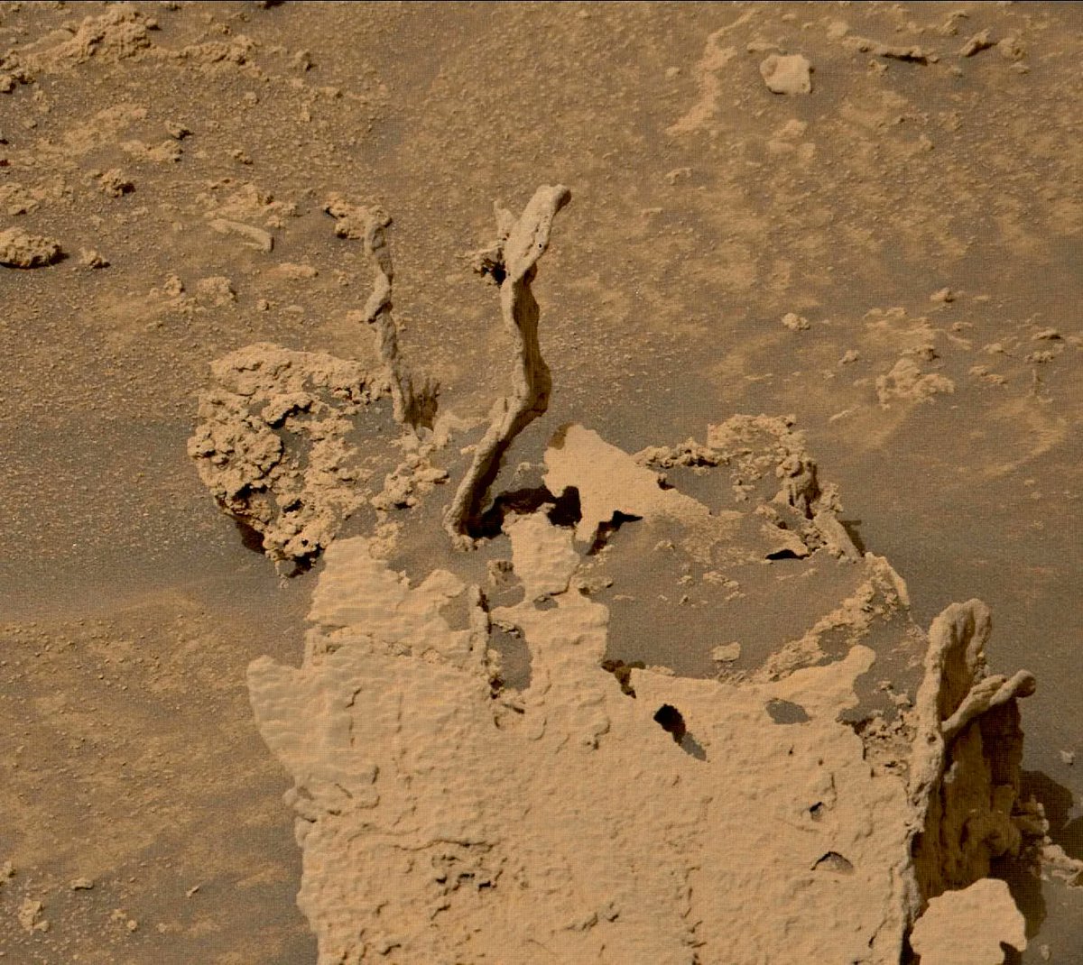
Curiosity Has Found Some Truly Weird-Looking, Twisty Rock Towers on Mars


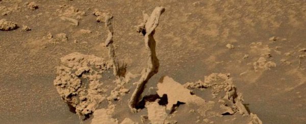
Rock formations on Mars. (NASA, JPL-Caltech, MSSS)

CARLY CASSELLA
7 JUNE 2022

The Curiosity rover has found an outstanding rock formation piercing the alien landscape of Mars. Amongst the shallow sands and boulders of the Gale Crater rise several twisting towers of rock – the spikes of sediment look almost like frozen streams of water poured from an invisible jug in the sky.

In reality, experts say the columns were probably created from cement-like substances that once filled ancient cracks of bedrock. As the softer rock gradually eroded away, the snaking streams of compact material remained standing.

Rock formations found on Mars. (NASA, JPL-Caltech, MSSS)

The rock formations were snapped by a camera on board the Curiosity rover on May 17, but the image was only shared last week by NASA and experts at the SETI institute (which stands for the Search for Extraterrestrial Intelligence), as part of SETI's planetary picture of the day initiative.


As alien as the structures might look, they aren't without precedent.

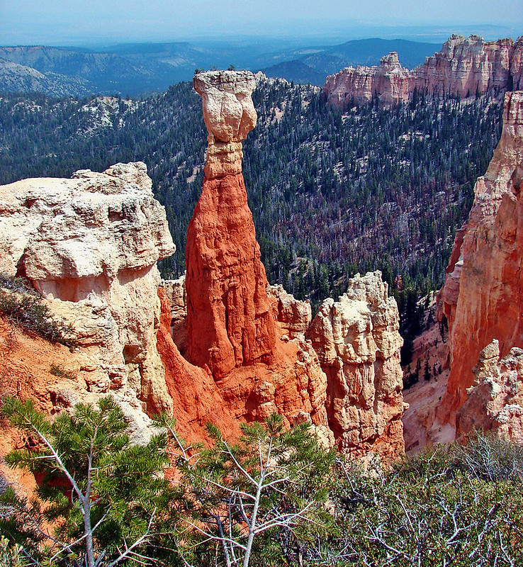
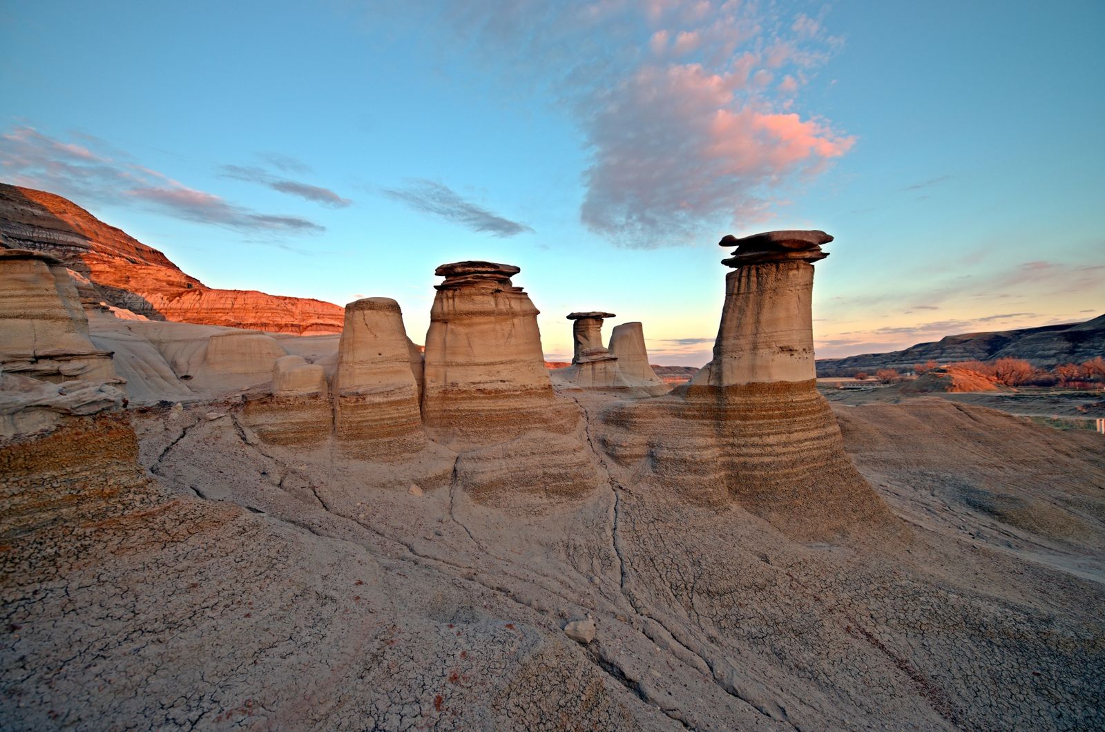
In Earthly geology, a 'hoodoo' is a tall and thin spire of rock formed by erosion. It can also be called a tent rock, fairy chimney, or earth pyramid.

Hoodoos are usually found in dry environments, like the canyons of Utah or southern Serbia, and the columns can sometimes tower as high as ten-story buildings.

A hoodoo in Bryce Canyon, Utah. (Don Graham/Flickr/CC BY SA 2.0)

The natural structures are formed by hard rock layers that build up within softer sedimentary rock. As the rest of the rock erodes away from rain, wind or frost, you're left with a magnificent mould of an ancient fracture in the bedrock.

Hoodoos East Coulee, Alberta, Canada. (Darren Kirby/CC BY SA 2.0)

The two towers of rock on Mars look like they are about to topple over compared to the ones we see on Earth, but clearly they are solid enough to withstand the lighter surface gravity experienced on the red planet.

Another strange rock formation found by Curiosity earlier this year might have been created in a similar way, albeit with very different results.

This other, smaller rock looks sort of like a piece of coral or a flower with numerous little petals stretching up towards the sun.

"One theory that has emerged is that the rock is a type of concretion created by minerals deposited by water in cracks or divisions in existing rock," a press release from NASA explained at the time.

"These concretions can be compacted together, can be harder and denser than surrounding rock, and can remain even after the surrounding rock erodes away."

A flower-shaped rock found on Mars. (NASA, JPL-Caltech, MSSS)

The Gale crater isn't wholly flat, but the alien spires discovered by Curiosity stand out from the rest of their environment, although no height measurements accompany the image.

The towering tombstones of rock might look lifeless now, but their formation speaks volumes about ancient conditions on Mars and whether life could have once thrived there billions of years ago.

The Gale crater itself is thought to be a dried-up lake bed, though possibly shallower and more transitory than experts once assumed.

Rock formations in and around the ancient lake are helping to reveal the region's true history.


Cutting Air Pollution Could Help Us Feed The World More Easily. Here's How

6 JUNE 2022

Planting more crops isn't the only way to feed a growing population. Cutting air pollution could go a long way towards increasing crop production while saving precious land and money, according to new research.

If the world cuts the emissions of just one type of air pollutant in half, estimates suggest winter crops could yield about 28 percent more in China and up to 10 percent more in other parts of the world. 

The pollutants in question are oxides of nitrogen, a family of invisible, poisonous gasses produced by car exhaust and industrial emissions that include nitrogen dioxide. 

Nitrogen oxide emissions are some of the most widely distributed air pollutants in the world, and it's suspected that if plants are exposed to higher levels of these gasses, their leaves can be damaged and their growth stunted, although experts are still figuring out exactly how.

At the same time, nitrogen oxides are also precursors to the formation of ozone and tiny aerosols in the atmosphere, which can dim sunlight and reduce crop productivity in turn.

Last year, research by some of the same authors found that reductions in ozone, particulate matter, nitrogen dioxide, and sulfur dioxide caused a 20 percent increase in corn and soybean yields in the United States between 1999 and 2019. 

That's around US$5 billion dollars worth of crops saved each year by reducing just four types of air pollutants. 

Nitrogen dioxide is one of the easier pollutants to measure regionally, and directly compare to crop growth. When emitted into the atmosphere, nitrogen dioxide interacts with ultraviolet light in a way easily detected by satellites.

"Nitrogen oxides are invisible to humans, but new satellites have been able to map them with incredibly high precision," explains agricultural ecologist David Lobell from Stanford University.

"Since we can also measure crop production from space, this opened up the chance to rapidly improve our knowledge of how these gasses affect agriculture in different regions."

Comparing nitrogen dioxide emissions in various regions of the world with the greenness of cropland, the team found a consistently negative effect.

The loss of greenery was especially noticeable in China and for wintertime crops like wheat. Using this correlation, researchers estimate that cutting nitrogen dioxide emissions by 50 percent would improve winter crop yields in China by roughly 28 percent. In summer, yields could improve by 16 percent.

In India, researchers predict nitrogen dioxide reductions could increase crop yields by up to 8 percent for winter, and 6 percent for summer. Meanwhile, in western Europe the yields for summer and winter crops could increase by 10 percent. 

When yield rates typically fluctuate around a percent every year, the effects of cutting air pollution could be immense for some parts of the world.

"The main take-home from this study is that the agricultural benefits of these actions could be really substantial, enough to help ease the challenge of feeding a growing population," says environmental scientist Jennifer Burney from the University of California San Diego.

We might not yet know how nitrogen oxides directly impact plant growth, but the strong relationship found in the current research suggests air pollution is contributing to crop losses around the world.

The study was published in Science Advances.


Iconic Siberian Tundra Is on Track to Entirely Vanish Off The Face of The Planet


STEPHANIE PAPPAS, LIVE SCIENCE
7 JUNE 2022

The Siberian tundra could disappear by the year 2500, unless greenhouse gas emissions are dramatically reduced. 

Even in the best-case scenarios, two-thirds of this landscape – defined by its short growing season and cover of grasses, moss, shrubs and lichens – could vanish, leaving behind two fragments separated by 1,553 miles (2,500 kilometers), scientists recently predicted.

And as the tundra's permafrost cover melts away, it could release vast quantities of stored  greenhouse gases into the atmosphere, potentially accelerating warming worldwide.

"This was stunning for us to see how quickly the tundra will be turned over to forest," said ecologist and forest modeler Stefan Kruse of the Alfred Wegener Institute (AWI) Helmholtz Centre for Polar and Marine Research in Bremerhaven, Germany.

The loss of the tundra will not only be a blow for biodiversity and human culture, but might also worsen Arctic warming, Kruse told Live Science.

Warming in the Arctic has advanced rapidly in recent decades, about twice as fast as warming in the rest of the globe. Between 1960 and 2019, air temperatures rose nearly 7.2 degrees Fahrenheit (4 degrees Celsius) across the Arctic region, according to the National Snow and Ice Data Center (NSIDC). This heat reduced sea ice cover and is affecting the Arctic's land as well. One of those implications is the northward march of Siberian larch forests.

How quickly these forests will replace the grassy, shrubby tundra ecosystem is unknown. Treeline changes in response to climate aren't consistent around the globe, Kruse said.

In some areas, treelines have advanced northward. In others, they have remained static; in still others, they've even retreated. Previous research in the Siberian tundra has focused on small areas, but there can be a lot of variability from location to location.

Now, Kruse and his colleague, AWI professor Ulrike Herzschuh, have created a new computer model that evaluates the full 2,485-mile-long (4,000 km) expanse of the Siberian tundra.

The model takes into account the life cycles of individual trees: from how far they can disperse their seeds, to how well they grow when faced with competition from other trees, to growth rates based on temperature, precipitation and depth of the summer thaw of permafrost that occurs in tundra regions.

The researchers found that once the trees start marching northward in response to warming, they do so quickly – and they are not likely to retreat again should temperatures cool. Under a scenario in which carbon emissions are reduced to zero by 2100 and global temperature rise remains below 3.6 degrees F (2 degrees C), only 32.7 percent of today's tundra would remain by 2500.

This fraction would be split into two mini-tundras: one in Chukotka in the far east and one on the Taymyr Peninsula in the far north.

Cascade of change

But even that bleak scenario may be impossible to achieve without very quick action, meaning that the outcome for the tundra could easily be far worse.

In an intermediate scenario in which carbon emissions don't start declining until 2050 and are cut by half by 2100, larch trees would cover all but 5.7 percent of the current tundra by 2500, essentially annihilating the ecosystem.

In the warmer global scenarios, trees could spread northward by as much as 18.6 miles (30 km), the researchers reported on May 24 in the journal eLife.

When Kruse and Herzschuh tested what would happen if temperatures cooled after the tundra became a forest, they found that the treeline did not retreat as quickly as it had advanced. Once mature trees are established, they can withstand a lot, Kruse said.

Related: When did scientists first warn humanity about climate change?

The study didn't directly model what might happen to tundra dwellers, such as reindeer, Kruse said, but splitting populations into two regions, where they are cut off from interbreeding, is typically bad for the survival of species.

Reindeer (known as caribou in North America) migrate from north to south and back again throughout the year, and it's not known how forest expansion may affect their migration and life cycles.

The impacts are likely to be felt by humans, too. Indigenous cultures such as the Nenets people of northwestern Siberia both herd and hunt reindeer.

"The culture is dependent partly on tundra," Kruse said. "If this gets lost, it will be a major loss for humanity."

How the loss of the tundra may affect future warming is also uncertain, but covering the mossy, scrubby grasslands with tall trees could make matters worse. Snow-covered tundra is lighter in color than larch forest canopy; the forests will therefore absorb more heat than the tundra does, potentially making the Arctic hotter, faster, Kruse said.

This additional heat could hasten and deepen the melting of the tundra's permafrost, which stores massive amounts of greenhouse gases – up to 1,400 gigatons globally, according to the NSIDC. Permafrost thaw could release these gases as well as long-frozen microbes and viruses.

Change will likely go beyond the replacement of tundra with larch trees, Kruse added. As warmer summers thaw deeper and deeper layers of permafrost, evergreen trees can then move in as well.

These trees remain leaf-covered year-round, potentially absorbing even more heat than larch do. The southern side of the taiga, where temperatures are already higher than in the north, will likely heat up even more, leading to drought and wildfires – which release still more carbon into the atmosphere.

The findings present compelling reasons to push for the ambitious reduction of fossil fuel emissions.

The model used in the study, however, can also be used to identify the most resilient portions of the Siberian tundra, Kruse said. These resilient areas could be prioritized for conservation investments. 

"The best option would be to reduce global greenhouse gas emissions to reduce the pressure," he said. "But nevertheless, if we cannot do that, one needs to do species conservation."

Related content:

What is global warming?

8 ominous climate milestones reached in 2021

Are we really running out of time to stop climate change?

This article was originally published by Live Science. Read the original article here.

Discovery Of 30 Curse Tablets Shows How Athenian Bathhouse Well Became A Chute To The Underworld


A WELL IS ONE WAY TO THE UNDERWORLD. IMAGE COURTESY OF DR JUTTA STROSZECK / GERMAN ARCHAEOLOGICAL INSTITUTE

By Rachael Funne
 IFLScience
06 JUN 2022, 

A bumper crop of curse tablets was retrieved from a bathhouse well in the Athenian Kerameikos in 2016, where they had sat undiscovered since the late-4th to early-3rd-century BCE. Curse tablets discovered in the region have typically been from the 5th and 4th century BCE and were mostly found in tombs – so why were these items found in a well?

Researchers involved in the discovery believe that a change in law may be to blame, as guards blocked people’s access to tombs in Athens where they probably would have preferred to commit their curses. Don’t you just hate it when that happens?

People seeking vengeance, therefore, had to get creative as to where they could dispel their curse tablets, and a public well may have presented the perfect opportunity. Furthermore, the fact that wells plunge into the ground may have led those in need of a good curse to think that this was an alternative route to the underworld while the tombs were out of action.

“The findspot in a bathhouse well can be related to the fact that curse tablets, which were in earlier times preferably deposited in certain kinds of tombs, were now dropped into wells that were seen as another possibility of access to the underworld,” said Dr Jutta Stroszeck from the German Archaeological Institute, Athens (DAI), to IFLScience.

“The change occurs after the reorganisation of the Athenian necropolis by Demetrius of Phaleron in 317/307 BCE, widely impeding the performance of magic at tombs.”

This liver-shaped curse tablet was retrieved from the bathhouse well. 
Image courtesy of Dr Jutta Stroszeck / German Archaeological Institute

Tombs were a favorite for curses as certain groups of dead people were believed to be the best curse bearers. In her paper, Stroszeck references another group of curse tablets dating to the 3rd century CE from Kourion, an ancient site on the south coast of Cyprus, which came with detailed instructions as to where to put a curse tablet within a necropolis. They included:children and others who “died before their time” (ἄωροι)
poor people who were “without proper burial” (ἄποροι ταφῆς)
people who were “violently killed” (βιαιοθάνατοι), such as murder victims
criminals who had been “axed” to death (πεπελεκισμένοι)
people who were “in a mass grave” (πολυάνδριοι), such as war casualties

It seems when these preferred curse bearers were in short supply, the plunging depths of a well had to make do for people to plop their curses into. The 30 curse tablets they found there were interesting in their diversity, as they included new forms such as one that looked like a liver, and another made to look like a knife.

“The new pieces teach us that there was a variety of forms created for this purpose,” said Stroszeck. “Apart from the more common tablet or stripe form that both go back to ancient writing utensils.”

Curse tablets from Athens were often used against opponents in law to stop the cursed from being able to talk, move or even think, giving the curse-caster the advantage. They were also used by love rivals, says Stroszeck, and Haaretz reports that a curse from someone jealous of a newlywed's marriage made special mention of the cursed bride's vulva.

Even charioteers would resort to curses ahead of athletic contests as a way of besting their competitors. Underworld? More like unsporting.


More children died from gun violence than car crashes in 2020. Are school shootings to blame?

flowers candles memorial
Credit: Unsplash/CC0 Public Domain

Gun-related deaths have overtaken auto accidents as the leading cause of death of children in the United States, The New England Journal of Medicine reported in May.

The 45,222  in 2020—"a new peak," according to NEJM—was a 13.5% increase from 2019, and is largely attributed to an increase in homicides rather than suicides. Of the deaths, 10% were children ages 1 to 19, making 2020 the first year that firearms were more deadly for children than auto accidents.

In light of the recent string of  in the United States, including the horrifying murders of 19 children and two teachers at Robb Elementary School in May, it may be tempting to attribute this development to mass shootings. But Northeastern researchers say that doing so is a misunderstanding of the real risks involved with  in the United States.

The general increase in  between 2019 and 2020 is somewhat of a mystery.

"In general, 2020 was sort of an unprecedented year for increases in homicides, particularly firearm homicides," says Matthew Miller, professor at Northeastern's Bouvé College of Health Sciences.

But, he says, "Nobody knows why."

There are many theories that could explain the increase in overall gun deaths, including shifts in policing after the George Floyd murder, or increased stress during the COVID-19 pandemic. But there is no definitive explanation for it, Miller says—and strangely, crime didn't rise.

"It's not that we have a crime problem over the last year or so, it's a lethal violence problem," Miller says.

Auto deaths, on the other hand, have been trending down since the mid-20th century, making the overlap with firearm deaths almost an inevitability. Miller calls the drop in auto deaths "a huge public health success story."

Over the past half century, he says, data from car crashes in the United States has been used to determine trends and eliminate risks. For example, over the years, trees on the side of the highway have been replaced with ditches. Cars are now manufactured with  in place, and as older models are taken off the road, driving becomes less deadly, Miller says.

The same can't be said of the country's rate of gun deaths, which trumps that of any other high-income country, Miller says. The United States is comparable to those countries when it comes to crime, Miller says, and even when it comes to violence. The difference, though, is that the tools that are used in the United States are more deadly.

"When we're violent, it's easy for us to reach for guns," he says. "And so it's easier for people to die."

In addition,  are far more common in the United States than other high-income countries, Miller says.

And yet, according to James Alan Fox, a criminologist at Northeastern University and an international expert on , the risk of school shootings in the United States is vastly overstated relative to other forms of gun violence.

"The average number of children who are killed at school by guns in an average year is about seven," he says.

If this figure seems low, it may be because of the media's inflated response to mass shootings, which Fox says can mislead the public about how gun violence usually happens. While the media might call mass shootings an "epidemic," Fox says deaths from mass shootings actually form "a small fraction of all the gun homicides in this country."

The confusion is in part due to the varying definitions of mass shootings. On June 3, The Washington Post published an article titled "Mass shootings in 2022: US sees more than 200 so far"—here, "mass " is defined as four people or more shot. On the same day, the New York Times published "At Least 18 Mass Shootings Have Happened in the U.S. So Far This Year," defining a mass shooting as an incident where "at least three people" were killed.

Citing hundreds of mass shootings per year obscures how few of those who die from guns are dying in mass shootings, Fox says. According to data from the Gun Violence Archive, of the 233 mass shootings this year, 89 resulted in zero deaths, and 90 resulted in one death. The same dataset shows that the 261 deaths from mass shootings this year form a mere 1.42% of the 18,320 gun deaths in 2022. Moreover, Fox says, the public mass shootings that receive the most media attention are also a minority of the cases of mass shootings, which include domestic shootings and gang violence.

"People get confused and think it's an epidemic," Fox says. "It's not."

Rather, he says, "A large share of [shootings] are gang shootings, shootings over drug trafficking, shootings in the family," Fox says, "not public places."

To support this, he notes that the statistic about child deaths in the U.S. includes teens aged 15 to 19, who accounted for 83% of the child deaths in 2020.

Despite the truth about gun violence, though, "there tends to be inflated coverage," around school shootings, and this can influence how the public perceives risk, says Susan Mello, an assistant professor of communication studies at Northeastern.

"If you put it on an objective spectrum of what actually are risks to society, these school shootings are low," Mello says.

But public perceptions of risk don't always match reality. For example, the public's perception of the risks of driving is "astronomically low compared to what they actually are," Mello says. "Because it's become such an integrated part of our lives, we're desensitized to the actual objective risk. We've just come to accept it as part of our life, unfortunately."

Still, "It would be a mistake to say that guns aren't a huge risk," Mello says, citing the risk of having a gun in the home. "The percentage of kids who are in households in the United States where there are guns that are not locked up is horrifying," she says.

This misunderstanding of gun risks means that measures that are taken or proposed after a well publicized school shooting may actually be counterproductive. For example, Miller says that gun purchases actually go up after school shootings, something that is more likely to put families in danger rather than protecting them. Proposed measures like arming teachers and locking classrooms from the inside also add risk, Fox says. Moreover, he says, school shooting drills can actually traumatize children, and he recommends simply talking to children.

Instead, Miller would like to see guns become much more difficult to acquire, by raising the age of purchasing, starting buyback programs, and banning assault weapons altogether.

"Then you'd see a big decline in suicide rates, and you'd see a decline in murder rates," he says.

For his part, Fox says universal background checks will help reduce general gun violence. While this won't solve the problem of mass shootings—most public mass shooters, he says, obtain their guns legally—it would help stem the tide of more common gun violence.

Unfortunately, neither Fox nor Miller is optimistic that big measures can be taken in the current political climate.

"The fact of the matter is that we have about 350 million guns in the country, and there's no quick fix for that," Fox says.Research team uncovers changes in the people and places impacted by interpersonal firearm violence following COVID-19

More information: Jason E. Goldstick et al, Current Causes of Death in Children and Adolescents in the United States, New England Journal of Medicine (2022). DOI: 10.1056/NEJMc2201761

Journal information: New England Journal of Medicine 

Provided by Northeastern University 


Bacterial cellulose in kombucha enables microbial life under Mars-like conditions

Bacterial cellulose enables microbial life on Mars
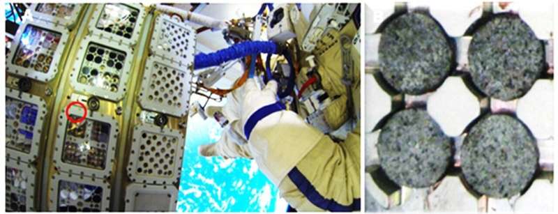
Section of the EXPOSE-2 platform outside the International Space Station (ISS) 
simulating a Mars-like environment that was used for the experiments. 
Credit: European Space Agency (ESA)

An international research team including the University of Göttingen has investigated the chances of survival of kombucha cultures under Mars-like conditions. Kombucha is known as a drink, sometimes called tea fungus or mushroom tea, which is produced by fermenting sugared tea using kombucha cultures—a symbiotic culture of bacteria and yeast. Although the simulated Martian environment destroyed the microbial ecology of the kombucha cultures, surprisingly, a cellulose-producing bacterial species survived. The results were published in Frontiers in Microbiology.

The scientists of the "Biology and Mars Experiment" (BIOMEX) project had already sent kombucha cultures to the International Space Station (ISS) in 2014 with the support of the European Space Agency. The aim was to learn more about the robustness of cellulose as a biomarker, the genomic architecture of kombucha, and its survival behavior under extraterrestrial conditions. After one and a half years under simulated Martian conditions outside the ISS, the samples were reactivated on Earth and cultivated for another two and a half years.

The head of the University of Göttingen's Institute of Veterinary Medicine, Professor Bertram Brenig, was responsible for the sequencing and bioinformatic analysis of the metagenomes of the reactivated cultures and individual kombucha cultures in a team with researchers from the University of Minas Gerais in Brazil. "Based on our metagenomic analysis, we found that the simulated Martian environment drastically disrupted the microbial ecology of kombucha cultures. However, we were surprised to discover that the cellulose-producing bacteria of the genus Komagataeibacter survived."

Bacterial cellulose in kombucha enables microbial life under Mars-like conditions
Another platform (EXPOSE-R2) outside the International Space Station (ISS) for
 simulating a Mars-like environment that was used for the experiments.
 Credit: European Space Agency (ESA)

The results suggest that the cellulose produced by the bacteria is probably responsible for their survival in extraterrestrial conditions. This also provides the first evidence that bacterial cellulose could be a biomarker for  and cellulose-based membranes or films could be a good biomaterial for protecting life and producing consumer goods in extraterrestrial settlements.

Another interesting aspect of these experiments could be the development of novel drug delivery systems (for example, the development of medicine suitable for use in space). Another focus was on investigations into changes in antibiotic resistance: the research team was able to show that the total number of antibiotic and metal resistance genes—meaning that these microorganisms might survive despite antibiotics or metals in the environment—were enriched in the exposed cultures. "This result shows that the difficulties associated with  in medicine in space should be given special attention in the future," the scientists saidSpace Kombucha in the search for life and its origin

More information: Daniel Santana de Carvalho et al, The Space-Exposed Kombucha Microbial Community Member Komagataeibacter oboediens Showed Only Minor Changes in Its Genome After Reactivation on Earth, Frontiers in Microbiology (2022). DOI: 10.3389/fmicb.2022.782175

Provided by University of Göttingen 


Study of Indonesian protected marine areas suggests participation by Indigenous people more effective than penalties

Study of Indonesian protected marine areas suggests participation by indigenous people more effective than penalties
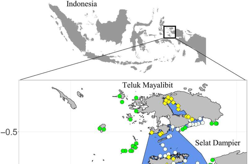
Location of ecological sites and settlements across the Bird's Head Seascape. Ecological
 treatment sites (n = 59) are represented by white circles, ecological control sites (n = 28)
 are represented by green circles, and settlement sites (n = 32) are represented by yellow
 diamonds. MPAs are bounded in blue. 
Credit: Science Advances (2022). DOI: 10.1126/sciadv.abl8929

A team of researchers affiliated with multiple entities in Indonesia and the U.S. has found that allowing Indigenous people to participate in management of protected marine areas is more effective than simply assessing penalties for violators. In their paper published in the journal Science Advances, the group describes their study of the volume of biomass in several parts of Bird's Head Seascape in Indonesia, which is part of what is known as the Coral Triangle.

Over the past several years, officials in Indonesia have recognized the need to protect parts of the sea surrounding their many-islanded nation. To that end, they have designated some areas as wholly protected and others as multiuse marine protected areas (MPAs), which means that they are protected in general, but fishing and some other activities by some people is allowed. Also, some MPAs are protected by laws that prohibit certain activities such as taking more than a certain number of fish; other MPAs are protected by the Indigenous people that live there. In this new effort, the researchers looked at the two approaches to determine which works best.

The approach involved analyzing a decade's worth of data from entities working in the Bird's Head Seascape area. The data covered hundreds of sites in four specific MPAs where fishing by Indigenous people is allowed. To measure the degree of protection at a given site, the team used the amount of fish biomass—the total mass of all the fish in a given area. Biomass measurements were obtained via questionnaires, discarded fishing equipment and camera surveillance. The team then compared the total biomass in a given area over time with the way the area was managed—by penalties or by Indigenous people running things.

The researchers found larger sustained amounts of biomass in areas controlled by Indigenous people compared to those controlled by  doling out penalties for infractions. The researchers suggest that allowing Indigenous people to manage MPAs is a better approach than heavy-handed penalties. They further suggest that more MPAs should be handed over to Indigenous people as a means for protecting  throughout Indonesia—and perhaps other parts of the world.Overfishing and other human pressures are severely harming marine protected areas worldwide

More information: Robert Y. Fidler et al, Participation, not penalties: Community involvement and equitable governance contribute to more effective multiuse protected areas, Science Advances (2022). DOI: 10.1126/sciadv.abl892

Journal information: Science Advances 

© 2022 Science X Network

The mandate effect: Official mandates can motivate the vaccine-hesitant to seek vaccination

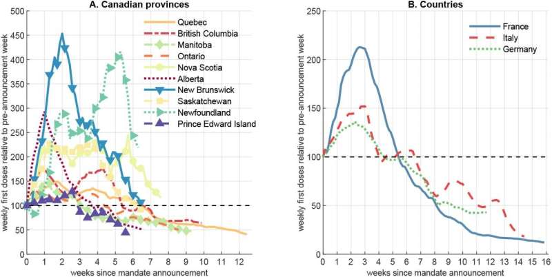
The mandate effect
Charts show the increase in COVID-19 vaccine uptake following the 
announcement of mandates for proof of vaccination to use certain public 
spaces. Credit: ©2022 Shigeoka et al.

Public health authorities seek to increase vaccine uptake, especially among those who are hesitant. But there is little evidence as to the best way to achieve this. New research suggests that rather than direct incentives, such as money, government-imposed mandates requiring vaccination to access certain public spaces could be the key. To explore this, researchers used the variation in the dates of mandates and subsequent COVID-19 vaccine uptake across Canadian provinces and European countries.

The COVID-19 pandemic has been a trying time for everyone. Amongst the challenges facing public health authorities around the world is the struggle to vaccinate as many people as possible in order to slow the spread of the virus. Although the majority of people do seem to realize the benefits of vaccination, people vary in how urgently they seek vaccination or in how hesitant they might be to vaccinate at all.

Different ways to encourage people to vaccinate have been suggested and tried, including public awareness campaigns and even financial incentives. But Professor Hitoshi Shigeoka from the Graduate School of Public Policy at the University of Tokyo and his international team have studied the impact of  mandates—requirements for proof of vaccination to use certain  and amenities—and found those might be more effective at persuading people to vaccinate.

"Despite the proven benefits of vaccination, uptake in many countries slowed in the summer of 2021, so naturally  wished to reverse that," said Shigeoka. "Previously, we investigated the effectiveness of mask mandates and found that those did lead to a reduction of cases. To follow up, we thought there might be a relationship between vaccine mandates and the uptake of vaccinations. Provinces in Canada, as well as the European countries of France, Italy and Germany, all issued mandates at different times and also had national vaccination programs. So we looked into what happened around and after the time the mandates came into effect or were announced."

Shigeoka and his team used a  called difference in differences to explore potential connections between mandates and vaccine uptake. Since the timing of the announcement of vaccination mandates differs across 10 provinces in Canada, ranging from early August 2021 (Quebec) to late September 2021 (Prince Edward Island), they used the provinces that had not yet announced vaccine mandates as the control groups for those which had already announced mandates.

"We knew there was increased uptake following the mandates, but something that surprised us was how much the mere announcement of mandates rather than their actual implementation boosted vaccination rates," said Shigeoka.

It's important to note that although this kind of data analysis about the effect of mandates is important for public health authorities, there are other related issues such as ethics, economics, politics, and other factors, which were not a part of this study.

The study is published in Nature Human Behaviour.

Vaccine hesitancy hardens in richer countries
More information: Alexander Karaivanov, COVID-19 vaccination mandates and vaccine uptake, Nature Human Behaviour (2022). DOI: 10.1038/s41562-022-01363-1. www.nature.com/articles/s41562-022-01363-1
Journal information: Nature Human Behaviour 
Provided by University of Tokyo