Tuesday, March 12, 2024


Journey to Sustainability: When Does the LNG “Bridge” Become the “Road”?
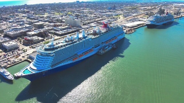
Carnival Jubilee
Carnival Jubilee (Carnival Corp.)

PUBLISHED MAR 11, 2024 8:13 PM BY SEAN M. HOLT


(Article originally published in Jan/Feb 2024 edition.)


In 2012, liquefied natural gas (LNG) as a marine fuel was a budding contender in the maritime industry, holding less than one percent market share.

At the same time, NASA's Aura satellite, equipped with an Ozone Monitoring Instrument, finished capturing images of elevated nitrogen dioxide (NO2) levels along shipping lanes, highlighting the environmental impact of traditional marine fuels.

These oxides of nitrogen (NOx) are known to produce fine particles and ozone, significantly harming cardiovascular and respiratory health—a concern underscored by the World Health Organization, which attributes approximately seven million premature deaths annually to air pollution.

The landscape has dramatically shifted forward since then: 469 LNG-fueled ships are now in operation with an additional 537 newbuilds on order. This surge places LNG at the forefront of the alternative fuel orderbook, as reported by DNV.

LNG's appeal lies in its ability to cut greenhouse gas emissions by 23 percent, sulfur emissions by 99 percent and nitrogen oxide emissions by nearly 99 percent. This is done by purifying and super-cooling natural gas to reduce its volume by 600 percent, enabling efficient transport and storage.

In the “basket of alternative fuels,” LNG stands out for its environmental benefits, established infrastructure and the industry's commitment to future-proofing maritime operations through significant investments.

SEA-LNG

Peter Keller, Chairman of the SEA-LNG coalition, and COO Steven Esau present a unified vision of the maritime industry's transition toward cleaner, sustainable fuel alternatives, particularly LNG.

Reflecting on the industry's evolution, Keller recounts the delivery of M/V Isla Bella to Tote in 2015, the first LNG-powered container ship, as a pivotal moment that heralded a new era: "Today, with over 1,000 LNG-fueled vessels either operational or on order, we're witnessing a remarkable surge in adoption. This growth, especially notable in the last two to three years, directly responds to increasingly stringent IMO regulations."

At the same time, he acknowledges the broader challenge of decarbonizing the global deepsea fleet, estimated at 60,000 vessels, and the critical issue of urban air quality.

Keller highlights LNG's environmental and operational advantages including significant reductions in sulfur oxides (SOx), nitrogen oxides (NOx) and particulate matter. He contrasts LNG's higher energy density with other proposed alternatives, which could affect cargo capacity and financial viability: "The logistical challenge of building infrastructure and supply chains for these fuels, especially in major ports like Singapore, Rotterdam and New York, cannot be overlooked. LNG's widespread availability and proven safety record make it a practical and immediate solution for reducing emissions."

Addressing concerns about methane slippage, Keller notes that advances in engine technology have significantly mitigated this issue. He emphasizes the importance of understanding the characteristics of available fuels and points out LNG's potential for reducing greenhouse gases by 23 percent using two-stroke technology with further gains possible as bio-LNG becomes more accessible.

Echoing his colleague’s sentiments, Esau questions the academic approach to decarbonization as lacking a practical understanding of the maritime industry: "Now that regulations must be complied with, shipowners are seeking viable pathways to decarbonization. LNG is proving to be the most viable and safest pathway for the maritime industry's decarbonization."

He underscores the necessity of actionable solutions over theoretical debates, highlighting LNG's role as a cornerstone in the industry's efforts to meet environmental regulations and achieve sustainability goals.

Keller concludes with a call to action: "Like Nike, Just Do It!" He calls for decisive steps toward adopting LNG and preparing for future advances. Hoping for a perfect fuel alternative is not a strategy. The industry must commit to viable, immediate solutions.

"Current LNG-fueled engines are adaptable, capable of 'dropping in' blends of LNG and hydrogen, which positions us well for a transition to bio, blue and synthetic LNG variants," he asserts.

Galveston LNG Bunker Port

Facing evolving regulatory challenges and a solid commitment to sustainability, the U.S. maritime industry is advancing with significant private capital to modernize Jones Act vessels and enhance port infrastructure.

An example is the collaboration between Pilot LNG and Seapath to develop the Galveston LNG Bunker Port (GLBP), slated to become the U.S. Gulf 's first dedicated LNG bunkering facility. The electric-driven facility will initially liquefy 300,000 gallons per day (gpd) from locally sourced natural gas, scaling to 600,000 gpd with two three-million-gallon storage tanks.

Anticipated to start operations by late 2026, the facility is a pivotal step towards aligning with stringent environmental regulations and shifting toward cleaner maritime fuel alternatives.

Benson Peretti, Executive Vice President of Seapath, emphasizes the strategic significance of GLBP: "Drivers such as IMO 2020 (limiting sulfur in fuel to 0.5 percent mass) and the U.S. being an Emission Control Area (more stringent at 0.1 percent) position GLBP to significantly reduce emissions in Galveston Bay." He highlights the facility's role in supporting operational needs for LNG-fueled vessels. This type of infrastructure enables the maritime and cruise industries to modernize their fleets by replacing older vessels and homeporting new, cleaner ships.

Reflecting on LNG's evolving role, Peretti asks, "LNG has been called a ‘bridge,’ but when does the 'bridge' become the 'road'?"

Considering LNG's more than a decade of use—nearly half the lifecycle of many ships—this question hints at the broader implications of shifting trade routes and the resonating effects of LNG infrastructure investments, which could yield unknown yet impactful dividends.

Captain Jonathan Cook, CEO of Pilot LNG, emphasizes the project's aim to address a crucial infrastructure gap – particularly in Galveston Bay and the greater Houston area, which comprise the U.S.'s largest port complex and fourth-largest cruise port. Establishing GLBP as a dedicated facility for supplying LNG bunker vessels and barges is a testament to the industry's foresight in enhancing these critical maritime hubs' operational capabilities and environmental performance.

Rodger Rees, Port Director and CEO of Galveston Wharves, further elaborates on the initiative's wider benefits, stating, "Providing LNG fuel at the port positions the Port of Galveston to attract the latest, technologically advanced cruise and cargo ships." He notes the environmental and economic advantages of adopting LNG including improved air quality and job creation, contributing to the port's and community's sustainability efforts.

Cruise Industry Adoption

The dual-fuel Carnival Jubilee, the first new ship to homeport in Galveston, showcases the cruise industry's dedication to LNG. The vessel has secured fuel services with Stabilis Solutions and Seaside LNG, utilizing a specially equipped barge for LNG delivery.

The arrangement highlights the operational flexibility of the Jubilee which, aside from running on LNG, is able to use traditional marine diesel fuel as well, ensuring a seamless transition toward cleaner energy sources.

Further emphasizing the cruise sector's investment in LNG infrastructure, again in Galveston, Royal Caribbean inaugurated a $125 million terminal in 2022, strategically positioned within a drive-to market accessible to an estimated 50 million people. The terminal's significance was evident during the 7,600-passenger Icon of the Seas’ shakedown cruise when CEO Michael Bayley alluded to future plans for the port.

"It wasn't an accident that we built that beautiful $100-and-whatever-it-was million-dollar terminal in Galveston, Texas,” he exclaimed, “which, by the way, is our highest-rated terminal experience in the world. I'm not giving away our strategy here, but if you use your imagination, big things are coming," hinting at Galveston's growing role as a key hub for LNG-fueled cruise operations and perhaps a third ship in the Icon-class after Star of the Seas.

JAX LNG

Pivotal LNG, a subsidiary of Berkshire Hathaway Energy, a conglomerate known for its comprehensive involvement in natural gas processing, pipelines, storage and LNG production, recognizes LNG as the most viable marine fuel solution for the North American market in the immediate future. 

Pivotal LNG operates three key facilities—JAX LNG, a joint venture between Pivotal LNG and Seaside LNG in Jacksonville, Florida, Towanda LNG and Trussville LNG—collectively producing 470,000 gallons per day and boasting nine million gallons of storage capacity along the East Coast.

JAX LNG is the pioneering facility, completing over 650 marine bunkerings including the M/V Isla Bella. With the additional access to Jones Act LNG bunker barges owned by Seaside LNG, the Clean Canaveral and Clean Everglades, JAX LNG is a leader in the LNG fueling space.

Journey to Sustainability

In the maritime industry's journey to sustainability, LNG has evolved from a transitional “bridge” to potentially becoming the “road” to the future. Infrastructure developments in fueling operations like the Galveston LNG Bunker Port (GLBP) and JAX LNG underscore the sector's commitment to cleaner energy.

With significant investments from industry giants like Royal Caribbean, which signal a broader shift toward LNG, ports like Galveston are poised to play a crucial role in accommodating LNG-fueled vessels.

This collective move toward LNG reflects the industry's dedication to a sustainable future. It redefines trade routes and operational strategies, marking a significant step in the maritime sector's embrace of LNG as a foundational fuel choice. – MarEx

Frequent contributor Sean Holt writes from Singapore.

The opinions expressed herein are the author's and not necessarily those of The Maritime Executive.
 

PERMANENT ARMS ECONOMY

U.S. Navy Pulls Together $9 Billion to Invest in Submarine Supply Chain

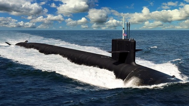
The future Columbia-class ballistic missile submarine (General Dynamics)

PUBLISHED MAR 11, 2024 8:17 PM BY THE MARITIME EXECUTIVE


Facing delays in the construction of its next-generation ballistic missile submarine, the Columbia-class, the U.S. Navy wants to plow billions of dollars into strengthening American companies that build submarine components. Its newly-released FY2025 budget cuts back on R&D spending, decommissions seven ships before end of service life, and puts $8.8 billion over five years into the submarine industrial base. 

Defense officials have quietly admitted that the first Columbia-class - which has been at risk of delays - is now on track to deliver in 2028, one year late. The main problems include issues with constructing its steam turbine plant and completing the bow section, according to USNI. 

The Columbia program is timed to replace the current Ohio-class ballistic missile sub fleet on a one-for-one basis, and any prolonged delay will mean that the Navy will have to extend the lives of some of the Ohios. 

The setbacks reflect capacity challenges in the submarine industrial base, including serious workforce recruitment issues. The Pentagon has been providing funds to these suppliers since 2018 to help them increase efficiency and boost production, and the new budget request would triple the amount spent previously. 

If adopted by Congress, this would be a historic investment in capacity-building. To help cover the cost, the service is cutting one Virginia-class sub from the usual two in the FY2025 budget. This reduces procurement on paper, but it brings the pace of new orders into line with the industry's actual delivery rate of about 1.2 Virginia hulls per year. 

Other cost-saving measures include early decommissioning of two more Littoral Combat Ships, USS Jackson (nine years old) and USS Montgomery (eight years old). This is the latest in a series of early retirement requests for the two LCS classes. 

For the first time, the Navy is also asking Congress for early decommissioning for Expeditionary Fast Transports (EPFs). The hulls on the list are the first four in the series, USNS Spearhead, Choctaw County, Millinocket and Fall River, and they range in age from 10-12 years. Other decommissioning requests include cruisers USS Shiloh and Lake Erie, the amphib USS Germantown, and the semisub transport ship USNS John Glenn (now only 10 years old). 

These candidates were selected based on a "hull-by-hull" analysis, Undersecretary of the Navy Erik Raven told USNI. 


Op-Ed: Maritime Security Sector Needs to Focus on Fundamentals, Not Tech

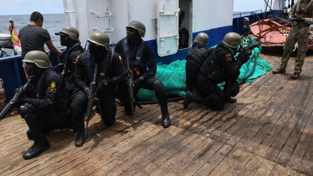
Nigerian Navy boarding team during an exercise, 2023 (USN file image)
Nigerian Navy boarding team during a maritime security exercise, 2023 (USN file image)

PUBLISHED MAR 11, 2024 9:33 PM BY CIMSEC


[By Jamie Jones and Ian Ralby]

What good is the world’s most advanced “dark targeting” platform to uncover previously untraceable vessels if the local navy, coast guard, or marine police cannot stop the crime?

Instead of being wooed by “game-changing” technologies, maritime security professionals should focus on ensuring their organizations can perform critical functions first. Similarly, professionals who partner with chronically under-resourced organizations should focus on assisting with basic functions instead of dangling “silver bullets” that promise to solve all their woes.

The Problem

The maritime security sector is under a constant barrage of hype about “game-changing” technology, particularly when it comes to maritime domain awareness (MDA). Maritime domain awareness is the effective understanding of anything associated with the maritime domain that could impact security, safety, the economy, or the marine environment. Several technological platforms are purported to “revolutionize” MDA with the promise of significantly improving countries’ abilities to govern their waters. Prominent examples include synthetic aperture radar (SAR), radio frequency identification (RFID), electro-optical (EO) satellite imagery, and artificial intelligence (AI) algorithms that use data from the Automatic Identification System (AIS) to evaluate vessels’ historical actions and predict future behavior. One company purports to be able to “quickly develop machine learning models to solve problems taking place in the vastness of the world’s oceans.” Similarly, new satellite-based technology supplied by the Quad (the United States, Australia, India, and Japan) is expected to help smaller island nations govern their waters.

Being able to watch bad actors on the water is not the same as being able to do anything to stop them. By itself, MDA has little deterrent effect: the waters will still be ungoverned if a country has no way to legally or operationally act upon what it sees. While new MDA technology can be exciting, the siren song of “shiny new toys” risks confusing maritime voyeurism with more assertive and effective action. For many countries, simply watching bad actors harm without the ability to stop them is frustrating. The constant stream of new—but sometimes proprietary or otherwise incompatible—technology can even create a disincentive to act and enable policy procrastination. Some policymakers want the equivalent of closed caption television on the water before they are willing to take action against problems like human trafficking, illegal fishing, and smuggling of drugs and weapons.

Before jumping to advanced technology, it is vital to be able to rigorously and systematically analyze MDA data from any source; have a repeatable, documentable mechanism for sharing that analysis with operators who can act on it promptly; have the capacity to plan and execute interdiction operations in a manner that also collects and preserves evidence; have a well-defined process for handing a maritime case over to the land-based authorities; and, ultimately pursue a legal finish that includes a penalty commensurate with the offense.

Man in the Loop

MDA technology cannot supplant humans; most Maritime Operations Centers (MOCs) run by militaries and law enforcement agencies employ several MDA analysts round-the-clock. These experts are needed to interpret what they see and then communicate their analysis to authorities who can act on this information and knowledge. In countries that lack funding or technical infrastructure for flashy MDA platforms, humans are even more important to the maritime security equation.

A well-trained analyst can, and must, perform functions that technology cannot. For example, to understand what might be happening in the water, the analyst must understand what should be happening. Understanding this context requires knowledge of local customs and culture, knowledge of a particular area’s fishing patterns, shipping routes, the effects of weather, seasonal dynamics, and knowledge of what is “normal” for that area. Indeed, relying only on technology may give the country a false sense of security, seeing some of what is happening in its waters without an in-depth understanding of the context.

Analysts must also be trained in maritime enforcement jurisdiction so they can understand what activities the country can pursue in each of the maritime zones their country has claimed.

Perfect Awareness is Useless without Action

The latest MDA technology often comes with a hefty price tag. Synthetic Aperture Radar capability, for example, is expensive and even analysts who are skilled at using other MDA sources cannot simply look at the blurry images of what amounts to satellite-based radar and make sense of it. That said, a suitably trained analyst looking at such radar captures in combination with other technology to correlate it to AIS data can help gain a clearer understanding of what is happening at sea. But this means that the expensive SAR data has to be paired with other expensive technology and a well-trained analyst for it to be of value. Even if these systems are provided cost-free, and analysts can translate the data into a useful understanding of actionable anomalies, interdictions still cannot occur without vessels on the water.

With initiatives such as the Australian and Japanese Patrol Boat programs, numerous developing nations now have access to vessels well-suited for patrolling their waters. These vessels, however, require well-trained crews, along with funding for fuel and maintenance to make them useful. In some countries, the government’s entire maritime force is required just to operate the vessel, which understandably discourages the frequency of its use. Access to parts, maintenance, fuel, and provisions conspire to keep these vessels pier side. Consistent funding and training for crews and boarding officers to interdict suspect vessels are necessary.

Though not as alluring as slick MDA technology, funding for the basic needs required to patrol waters should be prioritized over new technologies. Without basic operational capacity and capability, no amount of MDA will make a country’s waters safer, more secure, more stable, or more prosperous.

The other component to action besides “boots on deck” is the legal finish or the successful adjudication of a maritime offense. Indeed, a meaningful penalization through an adjudicative process is often the only effective deterrent to criminal activity in a country’s waters.

Behind a properly trained and funded boarding team are investigators trained in maritime cases. The investigators are critical to putting together a prosecutable case. Furthermore, prosecutors must be well-versed and well-trained in maritime law to successfully prosecute maritime crimes. And finally, the law itself must be fit for purpose, addressing the full spectrum of maritime offenses that are being pursued by criminal actors in the country’s waters.

The legal finish requires human resources. Human resources planning is difficult: it takes time to plan how many operations the country may need to conduct each year, and how many people need to be in place and trained to enable said operations. It requires recruiting the right people, funding their training, and then also a plan for retaining them once they are trained. Indeed, human resources are a significant, but necessary investment. Planning and funding for human resources may not sound as glamorous as showcasing the latest drone or artificial intelligence platform. But without human resources, the technology leaves the State’s deterrent capabilities impotent.

Conclusion

Flashy new technologies can be fun to play with, and some are truly useful. Still, they are only part of the equation for providing maritime security, and not necessarily the most important. To be useful, these tools must be paired with institutional capacity to analyze data, share information, plan and execute operations, collect evidence, handover to land authorities, conduct investigations, prosecute, adjudicate, penalize, and, when necessary, both legislate and regulate to account for changes in the security environment. Indeed, it is healthy and helpful to be skeptical of how much any technology will “solve” problems that require human expertise and human responses to be wielded effectively. It behooves those with meager budgets, and those trying to help partners with meager budgets, to focus funding and attention on building the skills and institutions needed to use the MDA technology that is already available, as well as whatever the future may hold. Every State should strive for maximum efficiency, effectiveness, and impact regarding maritime security concerns it can already see before pursuing a heightened visibility that may leave it watching bad actors without the wherewithal to stop them. 

Jamie Jones is a legal institutional capacity-building attorney with the Defense Institute of International Legal Studies (DIILS) focusing on maritime security in the Pacific Island Nations. She earned her undergraduate degree in agriculture from Kansas State University, a master’s degree in national security and strategic studies from the U.S. Naval War College, and her law degree from Washburn University’s School of Law. 

Dr. Ian Ralby is a recognized expert in maritime and resource security. He has worked in more than 95 countries around the world, often assisting them with developing their maritime domain awareness capacity. He holds a JD from William & Mary and a PhD from the University of Cambridge. 

The views presented in this article are the author’s own and do not necessarily represent the views of any other organization.

This article appears courtesy of CIMSEC and may be found in its original form here.

The opinions expressed herein are the author's and not necessarily those of The Maritime Executive.


Flight MH370's Disappearance Shows the Difficulty of Deep-Sea Search

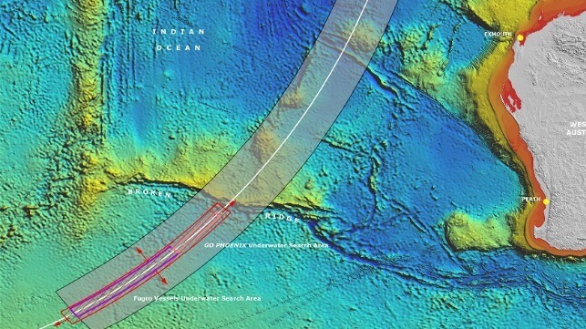
MH370 search area
A 2014 search plan shows the rugged contours of the Indian Ocean seabed (Australian Transportation Safety Bureau)

PUBLISHED MAR 11, 2024 8:42 PM BY THE CONVERSATION


[By Jamie Pringle, Alastair Ruffell Reader and Ruth Morgan]

It has been ten years since Malaysian Airlines Flight MH370, carrying 239 passengers and crew on board, disappeared less than one hour after taking off from Kuala Lumpur on 8 March 2014. It has become one of the great mysteries of modern times and is a puzzle that has remained resolutely unsolved.

Theories abound on the flight’s disappearance and current location of the wreckage. Unusually, all communications aboard the plane were switched off shortly after take-off.

Intermittent satellite location information subsequently suggested it was flown south on a very different flight path than expected, to a remote and deep ocean area of the Southern Indian Ocean before contact was lost.

When actively searching for MH370, sophisticated international surveillance aircraft initially conducted over 300 flights to visually look for plane debris on the surface. Then surface and submersible vehicles conducted further surveys, searching over 120,000 square kilometers of ocean before ending the search in 2017.

The effort to find MH370 became one of the most expensive aviation searches in history. These surveys used both sonar (active acoustic instruments to image the sea floor to locate the aircraft), and also listening devices to pick up the aircraft’s flight data recorder.

Confirmed MH370 plane debris was found on Reunion Island in July 2015 and off the coast of Mozambique in February 2016, which was consistent with what we know about ocean currents. In 2018, OceanInfinity, a private exploration company, also searched 25,000 square kilometers, but without success.

Since then, a mixture of highly trained experts and members of the public have sought to assist the search. These efforts have varied from simple to really advanced data analysis. They have attempted to map the locations and timings of plane debris, and other maritime debris, as well as model drift currents. In doing so, they are attempting to reconstruct where these may have originated from, which is no small task.

Analysis of the MH370 flight path has been pieced together from two different types of radar – primary and secondary – as well as the intermittent data “pings” from the plane to the Inmarsat satellite. The results suggest that it diverted south from its intended flight path.

Another technique called weak signal propagation (WSPR data (a way of using radio emission to track objects such as planes), had defined a specific but very large search area, some of which has already been searched.

Available hydroacoustic data (based on the way sound propagates in water) of the sea floor has also been analyzed. However, only a relatively small area was covered and the marine sea floor in this region can be very rugged. There are deep submarine canyons that can hide objects much bigger than a plane.

Lessons from studying past flight disasters also informed the search. These included the 2009 Yemenia plane crash in the Indian Ocean.

Recovery operation

For inland or coastal water searches, a phased investigation strategy is suggested as best practice, where investigators look to identify water depths, major current strengths and directions, together with pre-existing site information, before specialist search teams are employed using methods, equipment configurations and personnel that have all been accredited.

However this reliance on technology can be problematic. Even in small waterways, the presence of vegetation in the search area or a target buried by sediment can make these searches difficult.

Much of the Southern Indian Ocean sea floor is rugged and relatively unmapped, with water depths of up to 7,400 meters. It’s away from regular shipping lanes and commercial flight patterns, with few fishing boats, no significant land masses and some of the worst winds and weather in the world. These factors also make it a very challenging area to search.

In deep water (more than 2-3,000 meters) deploying sonar is cumbersome and prohibitively expensive. It also takes a long time to generate data. A major challenge for scanning technologies is achieving accuracy at these kinds of depths due to the scattering of the signal caused by uneven, especially rocky substrates on the sea floor.

The development of more advanced autonomous submersible vehicles may hold the key to finding MH370 in the Southern Indian Ocean, along with post-processing of raw data which can clarify what can be attributed to rocks as well as sea-floor hummocks and pockets.

This can distinguish between the sea floor and the objects being searched for. However, the area where MH370 disappeared is vast, meaning future searches will remain just as challenging as when the plane first went missing in 2014.

Jamie Pringle is a Reader in Forensic Geoscience at Keele University.

Alastair Ruffell is a Reader at the School of Natural and Built Environment, Queen's University Belfast.

Ruth Morgan is Vice Dean Engineering and Professor of Crime and Forensic Science at UCL.

This article appears courtesy of The Conversation and may be found in its original form here.

The Conversation

The opinions expressed herein are the author's and not necessarily those of The Maritime Executive.


MH370

MY THEORY: WATERSPOUT 


Huntington Beach Slick May Have Been From a Natural Seep

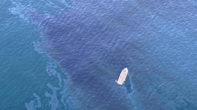
Slick off Huntington Beach
Image courtesy USCG

PUBLISHED MAR 11, 2024 9:25 PM BY THE MARITIME EXECUTIVE


The U.S. Coast Guard has concluded its response to a large oil sheen off the coast of Orange County, California, and the cause remains unknown. The area is home to natural oil seeps, and it is possible that the crude leaked out of the seabed on its own, though the event remains under investigation.

On Friday, the agency detected a 2.5-mile slick off Huntington Beach, an area known for its beaches and surfing spots. Response crews recovered about 85 gallons of oil from the water and about 1,000 pounds of oiled waste from the shore. 

Testing of samples from the slick revealed that the substance was lightly weathered crude oil, of Californian origin. The oil's chemical fingerprint did not line up with the characteristics of oil from nearby production platforms. It was also quite fresh, which is typical of natural seeps, according to the Coast Guard. The agency has no reports of any platform spill that might be related (though a small release of produced water did occur in the region at about the same time). 

The outcome of the oil release appears to be mild: beaches and fisheries remain open, public health appears unaffected, and three oiled birds were spotted and rescued for treatment.

"In the face of this environmental challenge, the strength of our partnerships has once again proven to be our greatest asset. The Coast Guard, the California Department of Fish and Wildlife's, Office of Spill Prevention and Response, and our local Orange County agencies and departments mobilized swiftly to mitigate the impact of the oil sheen off Huntington Beach," said Capt. Ryan Manning, the federal on-scene coordinator for the response. 

The response command believes that this was a one-time event, but the local lifeguard organization will watch for any signs of recurrence. 


Canada Bans Bottom Trawling Near its Only Pacific Coral Reef

Canada
Image courtesy Fisheries and Oceans Canada

PUBLISHED MAR 10, 2024 8:13 PM BY THE MARITIME EXECUTIVE


Canada has closed its only known live coral reef in the Pacific Ocean to all commercial and recreational bottom-contact fishing, including midwater trawling. The indefinite closure came into effect on February 14, 2024, according to Fisheries and Oceans Canada (DFO).

Located in Finlayson Channel, northern British Colombia, the site is a largely pristine cold-water live coral reef, which contains unique habitats, high biodiversity and has cultural significance to indigenous communities such as the Xai’xais and the Heiltsuk. It is the northernmost reef known in the Pacific Ocean.

The reef was first discovered in 2021 and mapped in 2022, following a joint effort involving federal authorities, civil society and indigenous communities. Currently, the coral reef is identified within the Northern Shelf Bioregion Marine Protected Area’s Network Action Plan, and is a proposed Parks Canada National Marine Conservation Area Reserve (NMCAR), which is in the feasibility assessment stage at the moment.

While the reef is remote and not widely fished, DFO has seen evidence of physical damage to the living coral, likely caused by bottom-contact fisheries. The protective measure is also based on a significant scientific discovery as this site, although small, is a globally unique reef that is susceptible to damage.

“This hidden hotspot is like a tropical coral reef but in the dark. When we ‘turn on the lights’ we see mounds and valleys, crabs, octopus, schools of fish and more,” said Dr. Cherisse Du Preez, Head of the Deep-Sea Ecology Program with DFO.

Another remarkable aspect is that the long margins of the coral reef touch and co-exist with glass sponge reefs. Since this is the only coral reef known to occur in Pacific Canada and glass sponge reefs only happen here, these margins may be the only place on Earth where this incredible interspecies relationship exists, added Dr. Preez.

Canada has another Lophelia reef along the edge of the Scotian Shelf, off the Canadian Atlantic coast. A Coral Conservation Area was established around it to support its recovery from significant historic damage.  


For people who speak many languages, there’s something special about their native tongue


An MIT study finds the brains of polyglots expend comparatively little effort when processing their native language.


MASSACHUSETTS INSTITUTE OF TECHNOLOGY


CAMBRIDGE, MA -- A new study of people who speak many languages has found that there is something special about how the brain processes their native language.

In the brains of these polyglots — people who speak five or more languages — the same language regions light up when they listen to any of the languages that they speak. In general, this network responds more strongly to languages in which the speaker is more proficient, with one notable exception: the speaker’s native language. When listening to one’s native language, language network activity drops off significantly.

The findings suggest there is something unique about the first language one acquires, which allows the brain to process it with minimal effort, the researchers say.

“Something makes it a little bit easier to process — maybe it’s that you’ve spent more time using that language — and you get a dip in activity for the native language compared to other languages that you speak proficiently,” says Evelina Fedorenko, an associate professor of neuroscience at MIT, a member of MIT’s McGovern Institute for Brain Research, and the senior author of the study.

Saima Malik-Moraleda, a graduate student in the Speech and Hearing Bioscience and Technology Program at Harvard University, and Olessia Jouravlev, a former MIT postdoc who is now an associate professor at Carleton University, are the lead authors of the paper, which appears today in the journal Cerebral Cortex.

Many languages, one network

The brain’s language processing network, located primarily in the left hemisphere, includes regions in the frontal and temporal lobes. In a 2021 study, Fedorenko’s lab found that in the brains of polyglots, the language network was less active when listening to their native language than the language networks of people who speak only one language. 

In the new study, the researchers wanted to expand on that finding and explore what happens in the brains of polyglots as they listen to languages in which they have varying levels of proficiency. Studying polyglots can help researchers learn more about the functions of the language network, and how languages learned later in life might be represented differently than a native language or languages.

“With polyglots, you can do all of the comparisons within one person. You have languages that vary along a continuum, and you can try to see how the brain modulates responses as a function of proficiency,” Fedorenko says.

For the study, the researchers recruited 34 polyglots, each of whom had at least some degree of proficiency in five or more languages but were not bilingual or multilingual from infancy. Sixteen of the participants spoke 10 or more languages, including one who spoke 54 languages with at least some proficiency.

Each participant was scanned with functional magnetic resonance imaging (fMRI) as they listened to passages read in eight different languages. These included their native language, a language they were highly proficient in, a language they were moderately proficient in, and a language in which they described themselves as having low proficiency.

They were also scanned while listening to four languages they didn’t speak at all. Two of these were languages from the same family (such as Romance languages) as a language they could speak, and two were languages completely unrelated to any languages they spoke.

The passages used for the study came from two different sources, which the researchers had previously developed for other language studies. One was a set of Bible stories recorded in many different languages, and the other consisted of passages from “Alice in Wonderland” translated into many languages.

Brain scans revealed that the language network lit up the most when participants listened to languages in which they were the most proficient. However, that did not hold true for the participants’ native languages, which activated the language network much less than non-native languages in which they had similar proficiency. This suggests that people are so proficient in their native language that the language network doesn’t need to work very hard to interpret it.

“As you increase proficiency, you can engage linguistic computations to a greater extent, so you get these progressively stronger responses. But then if you compare a really high-proficiency language and a native language, it may be that the native language is just a little bit easier, possibly because you've had more experience with it,” Fedorenko says.

Brain engagement

The researchers saw a similar phenomenon when polyglots listened to languages that they don’t speak: Their language network was more engaged when listening to languages related to a language that they could understand, than compared to listening to completely unfamiliar languages.

“Here we’re getting a hint that the response in the language network scales up with how much you understand from the input,” Malik-Moraleda says. “We didn’t quantify the level of understanding here, but in the future we’re planning to evaluate how much people are truly understanding the passages that they're listening to, and then see how that relates to the activation.”

The researchers also found that a brain network known as the multiple demand network, which turns on whenever the brain is performing a cognitively demanding task, also becomes activated when listening to languages other than one’s native language.

“What we’re seeing here is that the language regions are engaged when we process all these languages, and then there’s this other network that comes in for non-native languages to help you out because it’s a harder task,” Malik-Moraleda says.

In this study, most of the polyglots began studying their non-native languages as teenagers or adults, but in future work, the researchers hope to study people who learned multiple languages from a very young age. They also plan to study people who learned one language from infancy but moved to the United States at a very young age and began speaking English as their dominant language, while becoming less proficient in their native language, to help disentangle the effects of proficiency versus age of acquisition on brain responses.

###

The research was funded by the McGovern Institute for Brain Research, MIT’s Department of Brain and Cognitive Sciences, and the Simons Center for the Social Brain.


Experts create blueprint to aid elderly people at storm flood risk


UNIVERSITY OF BIRMINGHAM


Emergency planners in Shanghai and New York City face increasing pressure to protect elderly citizens from the devastating impact of coastal flooding caused by storms and cyclones, a new study reveals.

Both cities are highly exposed to storm-induced flooding and analysis shows that - with two distinct systems of emergency operation – there are significant differences between them in evacuating elderly people to safety.

After studying emergency operations in the cities, experts devised a blueprint for efficient evacuation that could be used in similar flood-threatened cities around the globe such as Mumbai, Bangkok, Jakarta, Ho Chi Minh City, Miami, and Tokyo.

An international group of researchers, including experts from the University of Birmingham, today published its findings in Nature Water. They recommend that emergency planners build more neighbourhood shelters, reducing the time taken to get vulnerable people in flood threatened areas to safety.

They note that travel times for New York City evacuation neighbourhoods are markedly less than 20 minutes, whereas each trip of flood evacuations can take up to 3-4 hours in Shanghai, since vulnerable neighbourhoods are underserved by shelters.

Professor Nigel Wright, from the University of Birmingham, commented: “Vulnerable neighbourhoods at the edge of coastal cities are most exposed to storm-induced flooding, but higher shelter capacity is in urban areas. Despite lower population densities than downtown areas, such communities tend to be populated by special need groups including the elderly.

“Differences in evacuation patterns for elderly residents in Shanghai and New York City, demonstrate the value of risk-informed, strategic evacuation planning for storm flooding. Our work provides new insights into operational emergency evacuation decisions and could provide a blueprint for flood management policy development in major coastal cities globally.”

The researchers note that many evacuation demands may arise from offshore islands such as Chongming island in Shanghai, where it is much harder for emergency responders to access evacuees in good time. Uneven distribution of vulnerable people together with centralisation of shelters leaves such exposed neighbourhoods underserved in extreme flood conditions.

As coastal societies with rising populations become more sensitive to disastrous flood events, China and the United States have begun to strengthen their emergency management process by improving organisation and planning of evacuation. Given the ever-changing nature of coastal flood risk, the experts recommend that further research on evacuation considers the effects of climate change, coastward urbanisation, and adaptation measures.

Recurring coastal flooding caused by storm surge is seen globally each year - becoming more frequent and devastating as climate-induced sea level rise, changes in storm characteristics, growing population and urbanisation and human-induced subsidence, lead to major impacts in low-lying coastal areas around the world.

Recent coastal flood catastrophes in Shanghai (1997), New Orleans (2005), New York City (2012) and Macau (2017) illustrate that coastal cities in both developing and developed countries are particularly vulnerable to storm surge flooding.

In the 136 largest coastal cities, the total population exposed to 100-year coastal floods is estimated to grow more than threefold from 38.5 million in 2005 to 150 million by the 2070s, with economic damage likely to increase to more than ten times the current levels (US$ 6 billion in 2005) by 2050.

In Europe, if no action is taken, the expected number of people exposed to coastal flooding annually is set to increase from 10,200 up to 3.65 million by 2100. This would occur mostly in major cities, due to rising extreme sea level and continued socioeconomic development.

ENDS

For more information, interviews or an embargoed copy of the research paper, contact pressoffice@contacts.bham.ac.uk or call +44 (0)121 414 2772

Notes for editors

  • The University of Birmingham is ranked amongst the world’s top institutions, its work brings people from across the world to Birmingham, including researchers and teachers and more than 8,000 international students from over 150 countries.
  • Strategic storm flood evacuation planning facilitates effective transfer of elderly population in large coastal cities’ - Jie Yin, Yuhan Yang, Dapeng Yu, Ning Lin, Robert Wilby, Stuart Lane, Bindong Sun, Jeremy Bricker, Nigel Wright, Lili Yang, Mingfu Guan is published by Nature Water.
  • The study involved researchers from the following institutions:
    • University of Birmingham, UK
    • East China Normal University
    • Loughborough University, UK
    • Princeton University, USA
    • University of Lausanne, Switzerland
    • University of Michigan, USA
    • Delft University of Technology, the Netherlands
    • Southern University of Science and Technology, China
    • University of Hong Kong, China