Monday, January 05, 2026

Ice-Breaking Tanker Keeps Sanctioned Russian LNG Flowing to China

Russia is keeping its sanctioned LNG trade with China alive during the winter thanks to an ice-class vessel capable of ploughing through the thick Arctic ice. 

The sanctioned Christophe De Margerie ice-class LNG tanker is set to export its third cargo since December 20 from the Arctic LNG 2 project in Russia, which is under sanctions by the United States, the EU, and the UK, vessel-tracking data compiled by Bloomberg showed on Monday. 

The Christophe De Margerie is the only ice-breaker tanker of the Russian shadow fleet that ship-tracking services have identified so far as operating on the route between Russia’s Arctic LNG 2 project led by Novatek and the Chinese LNG import terminal of Beihai. The Chinese port has specialized in recent months in accepting all the sanctioned Russian LNG cargoes, both from the Arctic LNG 2 plant and from the Portovaya LNG small-scale export plant on the Baltic Sea, Gazprom’s only LNG export facility. 

Arctic LNG flows to China have dwindled in recent weeks due to severe winter weather and the need for ice-breakers. With only one ice-class tanker capable of traveling through the Arctic ice all year round, Russia has boosted shipments from the Portovaya LNG on the Baltic Sea. Portovaya and its Russia-based operator, Gazprom SPG Portovaya Limited Liability Company, were sanctioned by the United States in January 2025 in one of the last actions of the Biden Administration in a barrage of sanctions to “degrade Russia’s energy sector.” 

As a result of increased shipments from sanctioned LNG export facilities, Russian LNG flows to China in November jumped more than twofold from a year earlier to reach a record high 1.6 million tons, making the country China’s second-largest LNG seller after Qatar. 

China received 22 cargoes to from Novatek’s Arctic LNG 2 export plant in 2025, data from Kpler cited by Reuters showed last week.     

By Tsvetana Paraskova for Oilprice.com


Ghana Takes Lead in Modernizing Short Sea Shipping in West Africa

Traffic at Port Abidjan, Ivory Coast, 2021 (Eric Browin / CC BY SA 4.0)

Published Jan 4, 2026 6:27 PM by The Maritime Executive


To boost coastal shipping in West Africa, Ghana has confirmed plans to establish a ferry service along the Lagos-Abidjan corridor. Last month, Ghana’s Transport Minister Joseph Nkipe confirmed to the local media that the planning for the ferry service is in advanced stages. A marine consultancy company has already been appointed to fast-track the development of the service.

The ferry service is reportedly nicknamed the "Afropax", and would provide first-of-its kind maritime connectivity in West Africa. The service involves linking Tema port in Ghana to other West African countries such as Benin, Togo and Nigeria. These countries are currently connected by the transnational Lagos-Abidjan highway corridor.

The highway is increasingly becoming a trade barrier for the region because of occasional congestion and delays, and a ferry service would act as an alternative to the road network. The sea route option could help cut carbon emissions compared to over-the-road haulage. It is estimated that 15,000 vehicles and over 500,000 people use the highway corridor each year, with the majority transiting between Ghana and Nigeria.

Initial plans from Ghana’s government indicate that two low-emission Ropax (Roll-on/Roll-off Passenger) vessels will be deployed on the route. The project will be backed by private investment with trial operations expected to begin next month. However, additional investment is needed to develop passenger and vehicle terminals in select ports along the corridor. In addition, a digital management system is needed for the operations of the ferry service.

Ghana’s President John Mahama has pledged support for the project, describing it as a timely development with potential to reshape regional trade in West Africa. The project also aligns with Ghana’s vision to improve regional maritime connectivity, with Tema port as a logistics hub in the Gulf of Guinea.

Water transport in the region has been relatively risky and often conducted in old wooden boats. Last year, hundreds of people lost their lives from capsizing of boats in West Africa. Overloading has been cited as a contributing factor in some of the incidents.

The EU is funding another water transport project in Lagos, a city with a population of 23 million people. The project intends to modernize ferry transport, spanning 140 kilometers across the city. The project will involve introducing 15 structured ferry routes as well as upgrading 25 ferry terminals.


Sanctioned Oil Tanker Goes Aground on the Rocks in Aegean

Qendil
Handout photo courtesy KEGM

Published Jan 4, 2026 2:50 PM by The Maritime Executive


A sanctioned shadow-fleet tanker has run aground off the coast of Bozcaada, Turkey, prompting a large-scale emergency response. The vessel was struck by Ukrainian drones in December. 

According to Turkish maritime safety agency KEGM, the 250-meter tanker Qendil was en route from Aliaga to Yalova when it drifted onto a rocky shore at Bozcaada (Tenedos), a scenic island in the Aegean just south of the entrance to the Dardanelles. The area is popular with tourists and filled with small islands, both Greek and Turkish-controlled. 

AIS data provided by Pole Star shows that Qendil went to anchor just southwest of the island on December 30 at a safe water depth for a vessel of her size. She held a relatively steady position at anchor through January 3, inscribing an anchor circle on a southwest-northeast axis.

At approximately 1030 hours GMT on January 4, the ship drifted from her anchorage and headed downwind, for reasons not yet officially established.

AIS trackline courtesy Pole Star Global

Qendil reached an unusual speed for a ship gone adrift - four knots, per AIS data - and came to rest about 100 meters offshore. Video from the scene shows the vessel buffeted by strong onshore winds and heavy waves.

Two tugs, Kurtarma-10 and Kurtarma-16, have been dispatched to the scene to assist. No pollution or injuries have been reported. The vessel is in ballast condition, KEGM reported, reducing the potential risk of pollution. 

Qendil (IMO 9310525, ex names Spark, Oilstar, Ionia) is a 115,000 dwt oil tanker built in 2006. She is currently flagged in Oman, owned in India and managed by a firm in China.

Qendil's last PSC entry was made three years ago, when she was under previous long-term ownership. In the intervening three years, the vessel has changed owners three times and registered under six different flags. Over the same period, she made frequent visits to the St. Petersburg region, one of Russia's three main oil export hubs, and to Vadinar and Mangaluru, two Indian ports known for importing gray-market Russian crude. Qendil's age, management, operating route and registration pattern align with Russia-serving shadow fleet participation, and she has been sanctioned by some (but not all) allies of Ukraine. 

According to OpenSanctions, the ship was formerly part of the sanctioned Oceanix Management FZE fleet and the former Gatik Ship Management fleet. She has been sanctioned by Canada, Australia, Switzerland and New Zealand.

Ukraine has sanctioned both the vessel and her master, identified by the GRU as Russian national Andrei Chumakov. The ship was attacked by Ukraine's drone forces in the Mediterranean in mid-December. 


Nigerian Police Arrest 22 Crewmembers After Finding Small Cocaine Shipment

Aruna Hulya (Cengiz Tokgoz / VesselFinder)

Published Jan 4, 2026 9:22 PM by The Maritime Executive


Nigerian authorities have arrested 22 crewmembers from a bulker after finding a small shipment of cocaine aboard the vessel. 

In November, the bulker Aruna Hulya got under way from Santos, Brazil - a notorious cocaine-trafficking hub - and got under way on a transatlantic crossing to Lagos, arriving December 26. The vessel moored at the GDNL terminal complex in Lagos. Upon boarding, Nigerian authorities found about 32 kilos of cocaine inside the number-three hatch, officials said in a social media statement.

Santos' cocaine trade is dominated by the gang known as the First Capital Command (Primeiro Comando da Capital, or PCC), which has made the agricultural hub into one of the world's busiest drug transshipment centers. The PCC is known to have transportation and distribution partnerships with its overseas counterparts - the 'Ndrangheta mafia in European consumer markets, and the Balkan criminal networks that dominate the Brazil-to-West Africa-to-Europe cocaine transshipment pipeline. 

Nigeria and its neighboring states have become a new stopover point on the ever-shifting network that connects abundant cocaine-producing regions in South America with users in Europe. From Brazil, the drugs arrive in Senegal, Ghana, Nigeria and neighboring states via a variety of maritime shipment routes. These kilo bricks are then transferred into "clean" containerized cargoes bound for European seaports. On arrival in Europe, a container from Nigeria looks less suspicious than a container from Santos, and the shipment might have higher odds of escaping detection by European customs. 

In general, merchant ship crewmembers often do not have knowledge of the presence of a cocaine consignment in a cargo container, hold or sea chest on their vessel. Smuggling gangs working with port-side personnel often place the goods without the crew's involvement, then retrieve the contraband at the destination port. In cases where crewmembers are involved, participation is often limited to a small group; nonetheless, some national jurisdictions hold the entire crew accountable when drugs are found on board.

Nigeria has conducted mass arrests before. In November, Nigerian officials detained all 20 crewmembers of the bulker Nord Bosporus after finding 20 kilos of cocaine concealed in the vessel's cargo. Like Aruna Hulya, Nord Bosporus' last port of call was Santos. 

Top image courtesy Cengiz Tokgoz / VesselFinder.


Archaeologists Unearth Ancient "Party Boat" in Alexandria's Harbor

The Greek graffiti found on the central carling are dated to the first half of the 1st century AD. Christoph Gerigk/Franck Goddio/Hilti Foundation

Published Jan 4, 2026 10:09 PM by The Conversation


[By Damian Robinson and Franck Goddio] 

Beneath the shifting waters of Alexandria’s eastern harbour, on Egypt’s Mediterranean coast, lie the drowned remnants of a once-splendid city – ports, palaces and temples swallowed by the sea. Submerged by earthquakes and a rising sea level, these lost monuments have become the focus of survey and excavations by the European Institute for Underwater Archaeology, in conjunction with Egypt’s Ministry of Tourism and Antiquities.

Much of our recent work has centered around Antirhodos Island, revealing a temple to the ancient Egyptian goddess Isis which was renovated by Cleopatra VII, and the Timonium – a palace built by her partner, the Roman general Mark Antony.

The shipwrecks from the Royal Port of Antirhodos tell the story of how Alexandria changed from a place emphasizing the great wealth and extravagance of the Ptolemaic dynasty to an economic powerhouse of the Roman world.

Our most recent excavations have revealed a shipwreck dating to the early Roman period. Buried beneath the sand were the remains of a thalamagos. This is a type of Nile yacht with a very colorful reputation in Roman literature as “party boats”. But the discovery of such a vessel in a busy commercial harbor was unusual. We asked ourselves: were we thinking about this wreck in the right way?

Discovering the ship

The wrecks in the Royal Port were discovered through a new high-resolution sonar survey of the seabed. This produced enormous quantities of data that was fed into a machine learning algorithm trained to recognise the “signatures” of shipwrecks. The initial results were promising, with excavations on targets generated by the algorithm revealing a small boat and a 30m-long merchant ship.

Together with a similar merchant ship found in the early years of the project, these finds illustrate the commercialization of the Royal Port in the Roman period.

At the outset of the 2025 mission, we were confident the wreck was a merchant ship. But with each dive, new findings reshaped our understanding, gradually revealing a vessel unlike the one we thought we were investigating.

The wreck has many typical features of Roman Imperial shipbuilding, but the Greek graffiti carved into its planks suggests that it was built and repaired in Alexandria. And its shape is unlike the cargo vessels found elsewhere in the Royal Port. At around 28m long and 7m wide, the preserved remains indicated that we were working on a flat-bottomed boat with a relatively wide and boxy hull. The bow and stern were asymmetrical, giving sweeping curves to the extremities of the ship. But it lacked a mast step, suggesting that it was rowed. The wreck did not have the ideal shape or propulsion system of a seagoing freighter, making it something of a mystery.

In search of clues, we turned to the 500 or so fragments of Ptolemaic and Roman papyri (the material made from the pithy stem of a water plant that these civilizations used to write on) that document nautical subjects. About 200 of these name different types of river vessels, which were often referred to by the cargoes that they carried, from grain, wine and stone to manure and corpses.

One of the infrequently mentioned types of boat is the thalamagos or cabin boat. This kind of vessel is depicted on the Palestrina mosaic, a roughly contemporary landscape with the boat found in a temple outside Rome.

With its crescent shape and series of oars, the mosaic ship bears a striking similarity to the material remains from the Royal Port. While investigations into our wreck are just beginning, it seems that we have found a thalamegos – one of the infamous “party boats” of the Nile.What happened on ancient party boats

The example on the Palestrina mosaic depicts a cabin boat being used to hunt hippopotami, a ritual associated with the Pharaohs of ancient Egypt. The link between this type of boat and royalty is heard in the philosopher Seneca’s dismissal of them as “the plaything of kings”.

While the Ptolemaic royal family did have Nile yachts, and even supersized versions of them, we can assume that vessels the size of ours would have been a common sight on the river. Indeed, the ancient geographer Strabo wrote about Alexandrians holding feasts aboard cabin boats in shady spots on the waterways around the city. He described them as part of the revelry and licentious behavior associated with the public festivals at the nearby town of Canopus.

These Roman authors, however, were likely playing up the culture of luxury and excess of their recently defeated enemy’s court and the “degenerate” lifestyles of its people. To simply think about our thalamagos purely as a party boat would be to cherry-pick racy Roman stories and fall for their propaganda.

The mundane detail of the administrative papyri reveals that thalamagoi were more than luxurious yachts. They could carry cargo and were also used to transport officials up and down the river. Consequently, the discovery of a cabin boat in a bustling commercial port is not entirely unexpected.

There is, however, another possibility. Our boat was found close to the temple of Isis and may even have been destroyed in the same seismic event that caused the collapse of this sanctuary. Was it a luxurious temple barge used during festivals such as the celebration of the Navigation of Isis?

This celebrated the “opening of the sea” following the winter season was one of the festivals that got Strabo so worked up about the behavior of its participants. It was actually a festival to ensure the protection of the grain fleet upon which Rome relied to feed its hungry urban population. Strabo chose to overemphasize aspects of the event to suit the anti-Ptolemaic prejudices of his Roman audience.

Detailed post-excavation analysis on this wreck is now underway. We want to understand exactly what our ship looked like and how it performed on the Nile. There is also more work to be done in the library with the ancient texts. What’s for sure is that we’re only just starting to get to know the secrets of this thalamagos.

Damian Robinson is Director of the Oxford Centre for Maritime Archaeology, University of Oxford.

Franck Goddio is a Visiting Professor at the Oxford Centre for Maritime Archaeology, University of Oxford.

This article appears courtesy of The Conversation and may be found in its original form here.

The Conversation

The opinions expressed herein are the author's and not necessarily those of The Maritime Executive.


Texas A&M Researchers Develop "Smart" Collision-Avoidance System

iStock
iStock

Published Jan 4, 2026 10:40 PM by The Maritime Executive


Researchers at Texas A&M University have made significant progress in the development of a computerized system that has the ability to combat collisions by giving seafarers real-time maneuvering advice. The ultimate goal is to save the shipping industry massive losses, including loss of lives, that are brought about by collisions.

Dubbed "Smart-Sea," the system combines raw radar imaging data with advanced machine learning is designed to give seafarers real-time guidance on how and when to maneuver their vessel to ensure safety. By providing information visually on a dashboard, seafarers will have a tool that empowers them to make a decision on maneuvering the vessel away from potential dangers. The system's vessel maneuvering model is based on seafarer experience, computational fluid dynamics models and machine learning trained on past vessel motions.

The team says that the raw radar images are processed using a machine learning tool that identifies and classifies stationary objects like offshore oil platforms and depleted wellheads, among others that are near the vessel. Once identified, the vessel’s maneuverability and seafarer’s experience level are considered to recommend the safest action for the vessel.  

To assess the effectiveness of the Smart-Sea, the researchers tested it aboard the Texas A&M research vessel Trident, with preliminary data supporting the prototype as a way to reduce marine collisions. The 70-meter vessel with a cruising speed of 17 knots supports a wide range of underwater study and exploration.

Human error remains the single major cause of collisions, with data from Europe offering a recent glimpse. In October, the European Maritime Safety Agency published its annual overview of marine casualties and incidents, covering the period from January 2015 to December 2024. During the period, over 26,000 casualties and incidents occurred, and nearly 65 percent were linked to human action. Just over 50 percent of the contributing factors were related to human behavior. The report shows that when considering both, nearly 80 percent of the marine casualties and incidents involved a human element.

The Texas A&M University researchers are developing Smart-Sea through initial funding from the U.S. Department of the Interiors and Energy. They hope to secure additional funding to continue testing the system on other vessels. While currently designed for large merchant vessels, the researchers believe that development of low-cost models could allow the system to be adapted for recreational vessels as well.


Aging Freighter Goes Aground in Sea of Marmara

White Line (Olaf / VesselFinder)

Published Jan 4, 2026 11:40 PM by The Maritime Executive


A freighter has gone aground on the northern shores of the Sea of Marmara, reportedly due to strong winds in the area.

On December 30, White Line arrived just off the coast of the port of Marmara and when to anchor. At about 1430 hours local time on Saturday, the vessel drifted from her anchorage and grounded just off a sandy beach, a tourist area known locally as Santos Plaji. Local outlet Sozcu reports that the ship was hit by a strong windstorm. 

No injuries or pollution were reported, and as of Monday the ship remained aground, attended by the SAR vessel Tahlisiye 12. Surface conditions were too rough for a dive inspection on Sunday, but a full examination will be made once seas are calmer, Sozcu reported.

The White Line is a 75-meter coastal freighter built in 1985. The ship is Turkish-owned and operated, and she conducts regional trade around the Mediterranean, Aegean and Black Seas, from Malta to Port Said to the Kerch Strait, AIS data shows.

The vessel has accumulated dozens of port state control deficiencies, and added more than 40 last year alone. PSC inspectors have cited at least one issue in nearly every boarding since 2017. Recent findings include shortcomings with fire safety equipment, fire dampers, fire doors, engine room cleanliness, propulsion or auxiliary engines, accommodations, crew certifications and logbooks, among others. 

White Line's grounding was one of two on Turkey's coastline over the weekend. The sanctioned oil tanker Qendil grounded just off Bozcaada on Sunday, coming to a rest near a rocky shoreline. 

Near Buyukada, on the eastern side of the Sea of Marmara, Turkish SAR responders prevented a third grounding through a swift response to a drifting vessel. The LPG carrier Bitihi 2 nearly drifted ashore near the island of Buyukada, but a salvage tug intervened and moved the ship to a safe anchorage off Tuzla, SAR agency KEGM reported.

Top image courtesy VesselFinder


After Sanctions Concerns, Palau Changes Management of its Flag Registry

Palau capital
Palau's flag flies over the capital in Melekeok (Binter / public domain)

Published Jan 4, 2026 11:43 PM by The Maritime Executive


Palau's government has ended a longtime commercial arrangement with its flag registry operator, according to the Island Times. The change follows several U.S. Treasury sanctions actions affecting the Palau-flagged fleet, and brings the register a chance for a fresh start.

In a statement Saturday, Palau's Ministry of Public Infrastructure and Industries confirmed that the Palau flag registry continues to provide all shipping registry services as before, but under new management. It emphasized its "commitment to strengthening governance and oversight, whilst maintaining continuity, experience, and confidence in the registry’s operations." It noted that the change should in no way reflect on the registry operator's former CEO.

“Our priority is to ensure continuity of service and the effective administration of the Palau Flag,” said Hayes Moses, director of the Palau Bureau of Marine Transportation. “All registry services continue to be delivered in accordance with established procedures and international standards.”

The Piraeus-based management firm began marketing and operating Palau's flag registry in 2012. This arrangement is not unusual: privatized management is common among open-register flag states. However, according to the Island Times, Palau's government developed concerns about some of the vessels that had made arrangements for the use of the Palau flag.

Vessels of concern may have included the tankers Iris, Mahadev, and Elke, allegedly part of Iran's Hossein Shamkhani network and recently listed by the U.S. Treasury. 14 other Iran-linked vessels with Palau flagging were listed by the Treasury in December. In addition, the LNG carriers Asya Energy, Everest Energy and Pioneer were listed by the Treasury in 2024 in connection with sanctions on Russia.

Palau's concerns are reported to have extended beyond sanctions. In 2024, under previous management, Palau's flag ranked second on the ITF's global list of seafarer-abandonment incidents - situations in which the owner ceases to pay wages to the crew or to provide basic supplies. In June 2025, Palau President Surangel Whipps said that he had not been aware of the abandonment cases.

"I didn't know about the issue [of seafarer abandonment]," Whipps told Thompson Reuters' Context. "We’ve got to clean that up. That's not good."

Going forward, newly-enacted amendments to Palau's Maritime and Admiralty Act will allow its government to "ensure a gradual and orderly transition" for its shipping register, its Ministry of Public Infrastructure and Industries (MPII) said in a statement. The amendments include new authority for Palau's president to appoint a contracted manager for the registry. 


Researchers Say the Oceans Have Passed a Milestone for Acidification

In 2025, scientists warned the ‘planetary boundary’ for ocean acidification had been crossed.

Coral
Toby Hudson / CC BY

Published Jan 4, 2026 11:47 PM by Dialogue Earth


[By Anna Napolitano]

The past 12 months have been worrying for researchers who study the chemistry of the ocean. More and more evidence has been published showing that human activities are fundamentally altering this chemistry in an acidic direction.

At the end of 2025, it seems clear ocean acidification is pushing the largest habitat on Earth into a risky zone.

Ocean acidification is part of the global carbon cycle. When carbon dioxide dissolves in water, it forms carbonic acid. This acid releases hydrogen ions, which lower the seawater’s pH balance.

pH balance

This sliding scale of 14 points indicates the acid/alkaline balance of a solution. Position 1 indicates the highest acidity, 14 the highest alkalinity. It stands for “potential of hydrogen”, because the scale is determined by the concentration of hydrogen ions.

Carbon dioxide emitted by human activities may be largely released into the atmosphere, but it does not all stay there. Huge amounts are absorbed by the ocean. A study published in 2023 determined that the ocean absorbed 25% of anthropogenic CO2 emitted from the early 1960s to the late 2010s. This has so far saved humanity from greater global warming.

Because of the rise in atmospheric CO2 concentrations over the past century, more CO2 has been taken up by the ocean, causing it to acidify.

How acidified is the ocean as of 2025?

Earth’s ocean has become roughly 30% more acidic than it was in the pre-industrial age, according to data from the European Environment Agency published in October. A huge part of that seawater pH decrease has come in recent decades. Just before the industrial revolution began in around 1750, Earth’s mean surface seawater pH was 8.2. By 1985 it had fallen to 8.11. By 2024, it was down to 8.04. 

This data indicates that pH at the surface of the ocean will decline even further by 2100, by between 0.15 and 0.5, depending on how much emissions are curtailed.

Also in October, researchers working at the Norwegian University of Science and Technology (NTNU) authored a study of ocean acidification models to quantify the global ecological and economic consequences of future acidity rises. “If in the years to come we continue on the current emission level, our models show that for most regions the ocean is on a trajectory toward worst-case scenarios,” says Sedona Anderson, lead author of the paper.

Why does this matter?

In May, a new study found that as acidification intensifies, the ocean’s capacity to absorb atmospheric CO2 weakens, reducing its ability to slow global warming. The explanation lies in chemistry: as the sea accumulates more carbon dioxide, its “carbonate buffering” capacity is reduced, making CO2 more chemically challenging to absorb. 

In March, researchers reported that the speed at which people are releasing CO2 into the atmosphere is much faster than the ocean’s natural capacity to absorb it without becoming acidic. This is profoundly altering the ocean’s chemistry. The consequences of the change are not yet fully clear.

What will happen to ocean animals with shells?

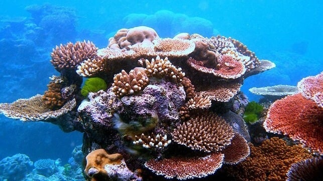
A study published in July explored the effects of ocean warming and acidification on two bryozoan species (invertebrate marine calcifiers) living in and around volcanic CO2 vents in the Tyrrhenian Sea, off Italy’s western coast. It found the populations of these animals are being increasingly depleted as the ocean warms in this particularly acidic environment. Calcifiers, such as corals, molluscs and terrapods, are small creatures with skeletons formed of calcium salts. Crucially, these creatures are foundational to food chains. They constitute, for example, about half of the diets of Arctic salmon.

In a collaborative study between Greenland and Spain published in 2016, it was concluded that calcifiers can meet the greater energy demands of processing calcium salts in more acidic environments by increasing their nutrient uptake; this has been seen on White Island in New Zealand. However, current models demonstrate that the ocean is becoming less hospitable, making it hard to provide the nutrients organisms need to cope with an already acidic environment.

Do we need to worry about humans and other animals, too?

While calcifiers are the first to suffer the consequences of a more acidic ocean, many other species, including humans, are set to pay the price if we continue on this trajectory. Upcoming research areas are focusing on the impact of changes in ocean chemistry on non-calcifying organisms.

In a summary about the “silent crisis” of ocean acidification published in April, experts from Spain’s Institute of Marine Sciences (ICM) highlight how data collected over recent decades is demonstrating that non-calcifying species, such as fish and squid, are suffering from impaired respiration, altered behaviour and reduced reproductive success in a more acidic environment.

The behavioural impacts are thought to be due to calciferous structures within fish ears that, like corals, cannot form properly in environments that are too acidic. This correlates with diminishing behavioural responses to danger. However, these are preliminary studies that focus on one generation of marine creatures only. More research in the field is needed.

Two other studies published this year, one observed in the Pacific and the other in the Mediterranean, found that the development and survival of mollusc larvae are negatively impacted by lower pH levels. A reduction in the number and characteristic variations of adult species was detected.

Though a direct correlation between increasingly acidic oceans and human health has not yet been explored, more than a billion people worldwide depend on healthy coral reefs for food and coastal protection. If these reefs become more fragile because they cannot properly build calcium shells, this will generate cascading problems. An acidic ocean will mean millions of dollars in lost fisheries and tourism revenue, because frailer coastal reefs will not provide the same level of coastal protection from storms.

What is the ocean acidification planetary boundary?

Perhaps the biggest news in ocean acidification this year is the warning that a new “planetary boundary” has been crossed.

In 2009, a group of scientists led by Potsdam University in Germany set out what they named planetary boundaries – nine limits to systems that have kept Earth’s environment stable during human existence. This project has become the annual Planetary Health Check report. One of the nine boundaries it investigates is ocean acidification. This is measured via the levels of aragonite in the ocean. Aragonite is a form of calcium carbonate used by huge numbers of sea creatures to build their shells and skeletons. When the ocean acidifies, carbonate ions become less abundant, making shell formation more difficult.

When the nine planetary boundaries were first established, the “safe limit” for acidification was set at a 20% reduction in the ocean’s aragonite levels, known as “aragonite saturation state”, compared to pre-industrial conditions. This figure was met with scepticism by some researchers in the field, who felt it was too high. “When the scientific community saw the data in the first planetary boundaries report, it quickly became apparent that that was just a best guesstimate,” says Helen Findlay, a professor at Plymouth Marine Laboratory in the United Kingdom.

In the years that followed, significant effort and resources were invested in analysing acidification in both pre- and post- industrial times, as well as in trying to better determine the acidification threshold after which catastrophic consequences take place.

In 2024, Findlay’s team reassessed those original thresholds. In a paper published in June 2025, the team concluded that the reduction in the ocean’s aragonite saturation state needed to be much lower than previously thought to keep the ocean healthy: around 10%, rather than 20%. The team estimated that by 2020, the global ocean was, on average, within the “uncertainty range of the ocean acidification boundary”. In other words, the boundary may have been crossed.

The deeper into the ocean the researchers looked, the worse the findings were. At 200 metres below the surface, 60% of global waters already indicated acidification levels beyond the newly established safe limit.

A few months later, the 2025 edition of the Planetary Health Check report confirmed this, reinforcing the idea that Earth’s oceans are now operating in a risk zone. Furthermore, following data revisions and thanks to advancements in data modelling since 2009, the 2025 report says the ocean’s pre-industrial aragonite saturation state was higher than originally thought. This means the drop in levels between the pre-industrial era and today has been more significant, blowing past even the team’s original ocean acidification “safe limit” threshold of a 20% drop in aragonite.

“When we published our first Planetary Health Check, several ocean experts told us that they could already see impacts on marine environments that didn’t align with an ocean operating in a safe zone,” says Levke Caesar, a member of the team that produces the report. “So, we thought that we should have reconsidered our study using more advanced data.”

Is every part of the ocean affected in the same way?

Ocean acidification is a widespread global problem but increasing amounts of research suggest some regions are more affected, especially the Arctic. These northern waters are very cold, and cold water dissolves CO2 more easily than warmer water.

In addition, some parts of the Arctic have major inputs of freshwater from rivers and melting ice. This reduces the local waters’ ability to buffer changes in pH, as an analysis of historical data published in April confirms.

Studies show the Arctic Ocean naturally experiences regional and seasonal variations in aragonite due to changes in ice and rivers. For example, before humanity started pumping out huge amounts of CO2, around 5% of polar waters became seasonally undersaturated with aragonite because of these natural seasonal shifts, according to Plymouth Marine Laboratory’s boundary reassessment. In the 2020s, however, that figure has risen to 21%. Some polar organisms are starting to exhibit the impacts of this change, Helen Findlay says.

Other studies show that coastal regions are more susceptible to acidification than offshore waters. In coastal areas, agricultural fertiliser runoff can increase the amount of nitrogen that ends up in the ocean. This can react with oxygen, causing local acidification and amplifying emissions-related acidification.

Work published in November shows that oceanic upwelling systems, such as the California Current, can also exacerbate acidification.

Can we learn from acidic oceans of the past?

More than 300 million years ago, volcanism massively raised CO2 levels in the atmosphere. This led to the end of what is known as the Late Palaeozoic Ice Age. As is happening today, the ocean sucked in much of the plentiful CO2 being held in the atmosphere, becoming more acidic in the process, as well as warmer and lower in oxygen. This led to the near-disappearance of calcifying organisms, such as coral reefs, and a mass extinction event sometimes called the Great Dying.

Scientists still debate the exact cause of that extinction event. “We know that the planet will find a way to survive. The question is if humanity will cope with the transition,” ponders Hana Jurikova, a researcher at the University of St Andrews’ School of Earth and Environmental Sciences, in Scotland. She was a lead author of an article on the end of the Late Palaeozoic Ice Age, published in early 2025.

Over the course of millions of years following the Great Dying, changes in oceanic pH were brought about by rock weathering and the degradation of mineral shells. The waters became less acidic, and ocean life rebounded until the dawn of the industrial age.

What can be done about it?

“Working in this field, I’m often depressed,” says Caesar. “Global regulations are needed, but there are also many solutions that [can] benefit most of the [planetary] boundaries.”

Zooming in, studies indicate that managing marine environments at a local level has a significant impact on multiple stressors. Such management can help mitigate the impacts of acidification. Restoring mangroves, wetlands and marine forests of algae, such as kelp and seagrass, and supporting farmers to reduce nutrient runoff into the ocean, can all help to balance seawater pH.

Other research is scoping out solutions to help the ocean recover from human-induced damage through direct intervention, too. Some of it considers the feasibility of adding minerals to the sea that could help reduce acidification, for example. Though other consequences of such an artificial strategy may be hard to predict.

Scientists consider acidification to be an escalating problem. This is primarily because achieving drastic reductions in anthropogenic CO2 emissions is looking increasingly challenging. Without those, ocean acidification will continue.

Anna Napolitano is a freelance science journalist who covers topics ranging from. health and medicine to the environment and oceans.

This article appears courtesy of Dialogue Earth and may be found in its original form here.

The opinions expressed herein are the author's and not necessarily those of The Maritime Executive.