Saturday, February 10, 2024


ECOCIDE

Mysterious Capsized Cargo Ship Causes Oil Spill Emergency in Tobago

Tobago oil spill
Oil is leaking from the capsized vessel as the authorities work to identify the ship and its owners (TEMA)

PUBLISHED FEB 9, 2024 12:04 PM BY THE MARITIME EXECUTIVE


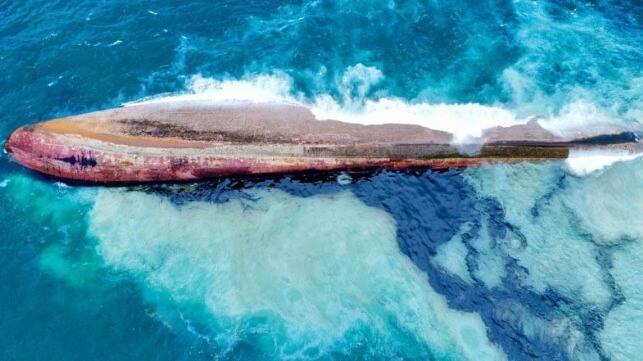
Officials on the Caribbean island of Tobago are scrambling to clean up a growing oil spill while they also investigate the mysterious capsized vessel that is causing the growing environmental disaster. Oil is fouling the southwestern end of the island with warnings that it may continue to spread.

A massive clean-up effort has been launched as the oil continues to wash onshore with the Trinidad & Tobago Coast Guard investigating the vessel. The government is now classifying it as a Tier II disaster with the Tobago Emergency Management Agency (TEMA), Environmental Management Authority, and other government agencies all coordinating in the effort. Speculation was that it would be elevated to a Tier III disaster by the end of the day Thursday or early on Friday.

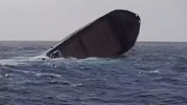
The incident began on Wednesday, February 7, when the authorities received reports of a capsized vessel. They noted that there had been no distress call and a subsequent search has failed to turn up the crew either on board or having escaped from the sinking ship. Oil from the vessel quickly began to reach the shoreline.


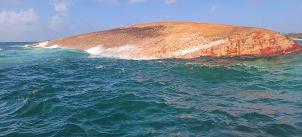
Oil is continuing to leak from the capsized cargo ship (TEMA)


Divers were sent to examine and identify the vessel reporting back a visual identity as Gulfstream but so far they have been unable to identify any registration information. Efforts to get to a possible registration number on the stern were being blocked by the ongoing oil leak. The vessel's visible name does not correspond with international ship registries.

They are estimating the vessel’s length at 330 feet (100 meters) and they believe it was transporting lumber and sand. The divers reported that there appears to also be damage to the nearby reef and that portions of the vessel’s superstructure detached and may lie in a debris field. 

They found no signs of life aboard the vessel, although further searches of the debris were planned. The speculation is that the vessel might have been abandoned and left to sink. The trail of damage suggests the ship drifted into the cove from the south and may have dragged along the bottom before coming to rest. Some observers are saying they saw the vessel as early as Tuesday.

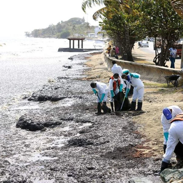
Crews worked through the day on Thursday and late into the night reporting that their focus is on containment and they have deployed protective booms. The port in Scarborough they are reporting so far remains oil free while testing is ongoing to confirm their suspicions that diesel oil is leaking from the ship.

Along the beaches, 67 people are reported to be working to clean up the oil while government officials are warning the public to stay away from southwest Tobago. One of the big concerns is that the oil will contaminate fish and the food supply.


Aging Freighter Sank Under Tow Due to Engine Room Flooding

Carib Trader II slips below (NTSB / Capt Beau)

PUBLISHED FEB 7, 2024 10:36 PM BY THE MARITIME EXECUTIVE


When the crew of the tug Capt. Beau set out to tow a derelict cargo ship from Miami to Haiti, they were in for an unwelcome surprise. Just about everything that could go wrong did go wrong: in rough seas, the towed ship payed out its own anchor, broke loose from the bridle, took on water and sank by the stern.

The ship in question was an aging 270-foot freighter, the Carib Trader II. The vessel was pushing 50 years old, and was not in perfect shape; she had a long history of inspection deficiencies, and had previously been found carrying cocaine. She was detained at Miami in November 2020 for a range of safety issues, and she stayed there for more than a year while arrangements were made for repairs. 

In February 2022, the owner arranged to tow Carib Trader II to Haiti, where the vessel would be repaired. The ship was surveyed above the waterline before departure, and the Coast Guard signed off on the tow plan. 

Capt. Beau set up a tow with a bridle of Spectra, chain and wire rope, rigged to the freighter's mooring bits. They got under way and headed south for the Old Bahama Channel.

On March 6, as they were under way off the coast of Cuba, the weather was on the rough side of what the tow plan allowed for. Winds were at up to 30 knots and seas were 7-9 feet. At about 0035 hours, the mate heard a bang, and the tug sped up on its own. The mate suspected that the tow might have parted, and he woke the captain, who took over the watch. The rest of the crew pulled in the tow line and found that both legs of the Spectra line bridle had parted. 

In the dark, the Capt. Beau maneuvered to recover the tow. At about 0140, the crew noticed that the Carib Trader's port anchor had payed out and was suspended in the water column. Ominously, the freighter was also trimmed by the stern. 

The crew rigged a tow by reconnecting to the remains of the bridle on the port side, and they resumed the tow at low speed, planning to investigate further after daybreak. 

At about 0720, the mate went aboard the Carib Trader to investigate. He found that the engine room was flooded and that the water had already risen above the main engine. At the captain's direction, the mate started up a portable dewatering pump and rigged it to pump the water over the side. 

The situation did not improve, and by 1100, the mate determined that the pump was not keeping up with the rate of flooding. By 1500, the Carib Trader began listing to starboard, and it became clear that the vessel would sink. The mate got off the vessel, and the captain had the engineer cut the tow wire free. Carib Trader II went to the bottom in 3,300 feet of water at about 1620.

Based on the available information and the Carib Trader's "substandard" maintenance history, NTSB determined that the likely cause of the sinking was an unidentified leak in the engine room below the waterline. The freighter had not been drydocked in years, and the condition of the hull was unknown. 

As for the parted bridle, the surface conditions at the time of the casualty were at the allowable limits of the tow plan, and would have placed stress on the towline. NTSB assessed that two unexpected sources of drag - the trailing anchor and the increasing draft of the Carib Trader's stern - further increased the strain, raising the odds that some component would part in the 7-9 foot seas.  


Response to Boohoo scandal failed workers it should have protected, shows new report


Modern slavery charges in Leicester masked the root causes of labour exploitation


Reports and Proceedings

UNIVERSITY OF BATH


University of Bath Press Release

Thursday 8 February 2024


A new report from the University of Bath has revealed the human consequences of pursuing modern slavery allegations, over supply chain failings, in Leicester’s ‘Boohoo Scandal’ in 2020.

The report draws on interviews with workers, manufacturers, and civil society representatives (including community organisations, unions and auditors), to hear their experiences of the closure of hundreds of factories when Boohoo moved its manufacturing out of the city.

Thousands of people, often vulnerable South Asian migrants, have been left without work, with the cost-of-living crisis meaning many are reliant on food banks.  

The government initiated Operation Tacit probed modern slavery allegations, concluding that while there were issues related to low pay and health and safety, there were no signs of modern slavery.

The University of Bath researchers say Boohoo made ‘face-saving’ changes to move most of its operations overseas, and pledged changes to business practices, shown by BBC Panorama investigations to be surface deep.

Professor Vivek Soundararajan, report author and researcher at the University of Bath’s School of Management, said: “Allegations of modern slavery, which were unfounded, obscured the root causes of worker exploitation, including manipulative procurement by fast fashion brands and lack of labour law regulation.”

Co-author Dr Pankhuri Agarwal, who conducted the research in Leicester said: “Framing it as a crime control and prevention issue meant Boohoo was able to distance itself from allegations of modern slavery by pulling out of Leicester or making only superficial business changes.

“Meanwhile the workers and some manufacturers, who are meant to be the motivating force in modern slavery measures, lost their livelihoods and are left with even fewer choices than before.”

The researchers conducted interviews in the summer of 2023 with workers, suppliers and others involved with investigating working conditions within Leicester’s garment industry, to produce the report entitled What happened after the Boohoo Scandal? A Multi-Stakeholder Perspective of the Garment Industry in Leicester.

The report is available to read in Hindi, Gujarati and Punjabi.

A former supplier to the Boohoo brand in Leicester told researchers: Companies like Boohoo can escape the consequences even after being exposed. They fail to pay a sustainable amount that will enable manufacturers to provide fair wages.

“Consequently, well-intentioned exposés, such as the Boohoo scandal, do not truly assign responsibility for those left behind, for those who bear the brunt of such industry-altering events. Brands merely shift their production to locations where cheap labour is readily available.”

Funded by UKRI, the report is part of a four-year research project to explore dignity in the workplace in the UK and India’s garment and software development industries.

Report co-author Dr Nandita Dutta said: “There were profound consequences of pressing charges of modern slavery against garment manufacturers. Vulnerable workers lost their livelihoods while brands emerged unharmed and the government remains unchallenged in its role of rendering workers susceptible to exploitative labour practices.”

The report recommends a range of measures that brands should adopt, including collaborative production models with manufacturers and measures suited to monitoring working conditions in factories with the help of manufacturers and workers.

It recommends that government incentivise brands to locate production sites in the UK and penalise any brands and employers that apply exploitative business models.

The report also recommends a range of measures from government to protect migrant workers, including certification courses for machinists without formal training, free ESOL courses (English for speakers of other languages) in factories, and funding for community organisations.

The report is available at: https://embed-dignity.com/18036-2/

ENDS


To arrange an interview or request information please contact the University of Bath Press office press@bath.ac.uk or call +44 1225 386319.

NOTES

The University of Bath is one of the UK's leading universities for high-impact research with a reputation for excellence in education, student experience and graduate prospects.

We are named ‘University of the Year’ in The Times and The Sunday Times Good University Guide 2023, and ranked among the world’s top 10% of universities, placing 148th in the QS World University Rankings 2024. We are ranked 5th in the UK in the Complete University Guide 2024, 6th in the Guardian University Guide 2024 and 8th in the The Times and Sunday Times Good University Guide 2024.

Bath is rated in the world’s top 10 universities for sport in the QS World University Ranking by Subject 2023. We produce some of the world’s most job-ready graduates and were named University of the Year for Graduate Jobs by the Daily Mail University Guide 2024, as well as ranking as one of the world’s top 90 universities for employer reputation according to the QS World University Rankings 2024.


Climate change to bring invasive weeds to mid-Atlantic and northeastern US states


A weed science society of America research summary identifies most likely high-impact, range-shifting invasive plants coming to the mid-Atlantic and northeastern US


Peer-Reviewed Publication

CAMBRIDGE UNIVERSITY PRESS

Invasive Plant Science and Management 

IMAGE: 

INVASIVE PLANT SCIENCE AND MANAGEMENT JOURNAL COVER.

view more 

CREDIT: WSSA


In an online article published In Invasive Plant Science and Management, vol. 16, issue 4, by Cambridge University Press, Justin D. Salva and Bethany A. Bradley performed and reported impact assessments on 104 plants most likely to expand with climate change into one or more Eastern U.S. States (Delaware, Kentucky, Maryland, New Jersey, Ohio, Pennsylvania, Virginia, and/or West Virginia) by 2050. Among these plants, 32 are high-impact species associated with negative impacts on ecological communities or multiple native species, and many are also associated with socio-economic impacts.

“The new research helps to prioritize which range-shifting invasive species to target in the region for proactive prevention and management,” says Bethany Bradley, Ph.D., Professor of Biogeography and Spatial Ecology in the Department of Environmental Conservation at University of Massachusetts - Amherst. “The impact assessment created in this study, and in related, companion papers in New York and New England states, can inform state weed risk assessments by identifying emerging invasive species most likely to cause negative impacts, including many that are tied to ornamental plant trade.”

More information is available in the article, “High-impact invasive plants expanding into Mid-Atlantic states - Identifying priority range-shifting species for monitoring in light of climate change Identifying Priority Invaders. Invasive Plant Science and Management is the official publication of the Weed Science Society of America.

About Invasive Plant Science and Management

Invasive Plant Science and Management is a journal of the Weed Science Society of America, a nonprofit scientific society focused on weeds and their impact on the environment. The publication presents peer-reviewed original research related to all aspects of weed science, including the biology, ecology, physiology, management and control of weeds. To learn more, visit www.wssa.net.


Ice cores provide first documentation of rapid Antarctic ice loss in the past


Peer-Reviewed Publication

UNIVERSITY OF CAMBRIDGE

Air bubbles in ice core 

IMAGE: 

EVIDENCE CONTAINED WITHIN AN ICE CORE SHOWS THAT IN ONE LOCATION THE WEST ANTARCTIC ICE SHEET THINNED BY 450 METRES — THAT’S MORE THAN THE HEIGHT OF THE EMPIRE STATE BUILDING — IN JUST UNDER 200 YEARS.

view more 

CREDIT: UNIVERSITY OF CAMBRIDGE/BRITISH ANTARCTIC SURVEY


Researchers from the University of Cambridge and the British Antarctic Survey have uncovered the first direct evidence that the West Antarctic Ice Sheet shrunk suddenly and dramatically at the end of the Last Ice Age, around eight thousand years ago.

The evidence, contained within an ice core, shows that in one location the ice sheet thinned by 450 metres — that’s more than the height of the Empire State Building — in just under 200 years.

This is the first evidence anywhere in Antarctica for such a fast loss of ice. Scientists are worried that today’s rising temperatures might destabilize parts of the West Antarctic Ice Sheet in the future, potentially passing a tipping point and inducing a runaway collapse. The new study, published in Nature Geoscience, sheds light on how quickly Antarctic ice could melt if temperatures continue to soar.

“We now have direct evidence that this ice sheet suffered rapid ice loss in the past,” said Professor Eric Wolff, senior author of the new study from Cambridge’s Department of Earth Sciences. “This scenario isn’t something that exists only in our model predictions and it could happen again if parts of this ice sheet becomes unstable.”

The Antarctic ice sheets, from west to east, contain enough freshwater to raise global sea levels by around 57 metres. The West Antarctic Ice Sheet is considered particularly vulnerable because much of it sits on bedrock that lies below sea level.

Model predictions suggest that a large part of the West Antarctic Ice Sheet could disappear in the next few centuries, causing sea levels to rise. Exactly when and how quickly the ice could be lost is, however, uncertain.

One way to train ice sheet models to make better predictions is to feed them with data on ice loss from periods of warming in Earth’s history. At the peak of Last Ice Age 20,000 years ago, Antarctic ice covered a larger area than today. As our planet thawed and temperatures slowly climbed, the West Antarctic Ice Sheet contracted to more or less its current extent.

“We wanted to know what happened to the West Antarctic Ice Sheet at the end of the Last Ice Age, when temperatures on Earth were rising, albeit at a slower rate than current anthropogenic warming,” said Dr Isobel Rowell, study co-author from the British Antarctic Survey. “Using ice cores we can go back to that time and estimate the ice sheet’s thickness and extent.”

Ice cores are made up of layers of ice that formed as snow fell and was then buried and compacted into ice crystals over thousands of years. Trapped within each ice layer are bubbles of ancient air and contaminants that mixed with each year’s snowfall — providing clues as to the changing climate and ice extent.

The researchers drilled a 651-metre-long ice core from Skytrain Ice Rise in 2019. This mound of ice sits at the edge of the ice sheet, near the point where grounded ice flows into the floating Ronne Ice Shelf.

After transporting the ice cores back to Cambridge at  -20oC, the researchers analysed them to reconstruct the ice thickness. First, they measured stable water isotopes, which indicate the temperature at the time the snow fell. Temperature decreases at higher altitudes (think of cold mountain air), so they were able to equate warmer temperatures with lower-lying, thinner ice.

They also measured the pressure of air bubbles trapped in the ice. Like temperature, air pressure also varies systematically with elevation. Lower-lying, thinner ice contains higher pressure air bubbles.

These measurements told them that ice thinned rapidly 8,000 years ago. “Once the ice thinned, it shrunk really fast,” said Wolff, “this was clearly a tipping point — a runaway process.”

They think this thinning was probably triggered by warm water getting underneath the edge of the West Antarctic Ice Sheet, which normally sits on bedrock. This likely untethered a section of the ice from bedrock, allowing it to float suddenly and forming what is now the Ronne Ice Shelf. This then allowed neighbouring Skytrain Ice Rise, no longer restrained by grounded ice, to thin rapidly. 

The researchers also found that the sodium content of the ice (originating from salt in sea spray) increased about 300 years after the ice thinned. This told them that, after the ice thinned, the ice shelf shrunk back so that the sea was hundreds of kilometres nearer to their site.

“We already knew from models that the ice thinned at around this time, but the date of this was uncertain,” said Rowell. Ice sheet models placed the retreat anywhere between 12,000 and 5,000 years ago and couldn’t say how quickly it happened. “We now have a very precisely dated observation of that retreat which can be built into improved models,” said Rowell.

Although the West Antarctic Ice Sheet retreated quickly 8,000 years ago, it stabilized when it reached roughly its current extent. “It’s now crucial to find out whether extra warmth could destabilize the ice and cause it to start retreating again,” said Wolff.


Inside the drilling tent at Skytrain Ice Rise, engineers and scientists separating the inner barrel of the drill from the outer barrel between drilling runs.

CREDIT

University of Cambridge / British Antarctic Survey

the drilling and living tents at Skytrain Ice Rise.

CREDIT

Eric Wolff


End of nuclear secrecy? Underground weapon tests 'now detectable with 99% accuracy'


Peer-Reviewed Publication

ROYAL ASTRONOMICAL SOCIETY

Earthquakes vs explosions diagram 

IMAGE: 

THIS DIAGRAM SHOWS 140 EXPLOSIONS AND 1,149 EARTHQUAKES ANALYSED BY RESEARCHERS. IT REVEALS THE EXPLOSIONS PREVIOUSLY MISIDENTIFIED AS EARTHQUAKES (RED DIAMONDS) AND EARTHQUAKES WRONGLY CLASSIFIED AS NUCLEAR BLASTS (GREEN DIAMONDS).

view more 

CREDIT: ANU


End of nuclear secrecy? Underground weapon tests 'now detectable with 99% accuracy'

Royal Astronomical Society press release

RAS PR 24/04

For immediate release


Secret underground nuclear tests could now be a thing of the past thanks to a major scientific breakthrough in ways to identify them.

A team of Earth scientists and statisticians say they can now tell with 99 per cent accuracy if such an explosion has taken place. This is up from 82 per cent and is based on a dataset of known tests in the US, according to the new study published in Geophysical Journal International.

It has previously been tricky to differentiate between nuclear explosions and other seismic sources, such as naturally-occurring earthquakes or man-made noise above ground.

“The explosion goes off and you have all this energy that radiates out, which can be measured on seismometers,” said lead author Dr Mark Hoggard, of The Australian National University (ANU).

“So, the science problem becomes how do we tell the difference between that and a naturally-occurring earthquake?”

This was an issue seven years ago, when several of the existing methods used to identify underground nuclear explosions failed to establish that North Korea had carried out such a test.

The secretive communist state later confirmed it had successfully tested a weapon with a force of between 100-370 kilotons. For comparison, a 100 kiloton bomb is six times more powerful than the one the US dropped on Hiroshima in 1945.

North Korea is the only country known to have carried out an underground nuclear test in the 21st century, but satellite imagery revealed last year that Russia, the US and China have all built new facilities at their nuclear test sites in recent years.

Although there is no suggestion the three superpowers are planning to resume such experiments, the war in Ukraine has made the global security landscape uncertain.

“By using some revised mathematics and more advanced statistical treatment, we have managed to improve the classification success rate from 82 per cent to 99 per cent for a series of 140 known explosions in the US,” Dr Hoggard said.

“Nuclear testing in the US has largely been carried out in Nevada – in the desert – and there is a thorough seismic record of all those tests, so it provides a really helpful dataset.

“Our new method also successfully identifies all six of the tests conducted in North Korea from 2006 to 2017.”

Dr Hoggard said there may still be instances of underground nuclear tests being carried out surreptitiously in some parts of the world, and the sheer volume of earthquakes makes it difficult to investigate each event to determine if it is suspicious or not.

“This makes effective methods like ours all the more important,” he added.

“It also doesn’t require any new kit - you don’t have to put up satellites or anything like that, we’re just using standard seismic data.”

Dr Hoggard described the model as “pretty fast”, making it “more or less suitable for real-time monitoring”.

The research was carried out by a team of Earth scientists and statisticians working at ANU and the Los Alamos government research lab in the US.

They say the new approach “provides a means to rapidly assess the likelihood of an event being an explosion”.

The mathematical model was built by analysing the physical differences in the pattern of rock deformation at the source of nuclear explosions and earthquakes, allowing experts to determine which seismic event a recorded noise is more likely to belong to.

International efforts shifted to monitoring significant seismic waves in the aftermath of the Cuban Missile Crisis and Partial Nuclear Test Ban Treaty in the 1960s, which limited the testing of nuclear weapons to underground only.

The agreement was introduced following years of environmentally-damaging experiments carried out at the surface and/or underwater. These polluted many locations and in some instances led to catastrophic levels of radioactive fallout.

But the new monitoring it required brought about its challenges - primarily how to differentiate between nuclear explosions and other seismic sources.

It has taken more than six decades, but the scientists behind the new research believe their innovative method could now make this a lot easier for groups such as the Comprehensive Nuclear-Test-Ban Treaty Organization (CTBTO), which is tasked with international surveillance of nuclear testing.

Dr Hoggard said his team’s mathematical model would be “another tool in CTBTO’s armoury for detecting any potential underground tests that are conducted in secret”.

He added: “A ban on all future tests is unlikely given that several major nations remain unwilling to ratify the Comprehensive Nuclear-Test-Ban Treaty.

“Well-supported monitoring programs are therefore critical for ensuring that all governments are held accountable for the environmental and societal impacts of nuclear weapons testing.”

The paper ‘Seismic moment tensor classification using elliptical distribution functions on the hypersphere’ has been published in Geophysical Journal Internationa


Images and captions

The images in this release are public domain.

1. Castle Bravo mushroom cloud Credit: Wikipedia

The 1954 Castle Bravo mushroom cloud, which was one of the most environmentally damaging nuclear tests ever carried out. It was a main contributor to the banning of all surface nuclear tests in 1963.

2. Earthquakes vs explosions diagram Credit: ANU

This diagram shows 140 explosions and 1,149 earthquakes analysed by researchers. It reveals the explosions previously misidentified as earthquakes (red diamonds) and earthquakes wrongly classified as nuclear blasts (green diamonds).


Science contacts

Dr Mark Hoggard, Australian National University

mark.hoggard@anu.edu.au

Tel: +61 434 403 585


Further information

The paper is available via the following link: https://academic.oup.com/gji/article/237/1/1/7597260


Notes for editors

About the Royal Astronomical Society

The Royal Astronomical Society (RAS), founded in 1820, encourages and promotes the study of astronomy, solar-system science, geophysics and closely related branches of science. The RAS organises scientific meetings, publishes international research and review journals, recognises outstanding achievements by the award of medals and prizes, maintains an extensive library, supports education through grants and outreach activities and represents UK astronomy nationally and internationally. Its more than 4,000 members (Fellows), a third based overseas, include scientific researchers in universities, observatories and laboratories as well as historians of astronomy and others.

The RAS accepts papers for its journals based on the principle of peer review, in which fellow experts on the editorial boards accept the paper as worth considering. The Society issues press releases based on a similar principle, but the organisations and scientists concerned have overall responsibility for their content.

Keep up with the RAS on XFacebookLinkedIn and YouTube.


Melting ice roads cut off Indigenous communities in northern Canada


AFP
Fri, 9 February 2024 

Snow melts on the roof of an ice fishing cabin in Sainte-Anne-de-la-Perade, Quebec, Canada in January 2024 (Anne-Sophie THILL)

Melting ice roads cut off Indigenous communities in Canada's far north as unseasonably warm weather on Friday also saw its largest city, Toronto, break a winter heat record.

Communities in Ontario and neighboring Manitoba provinces declared a state of emergency as the warm spell made the network of ice roads -- which across Canada spans more than 8,000 kilometers (5,000 miles) between dispersed populations -- unpassable.

Many remote communities in Canada's north depend on ice roads -- compacted snow and ice atop frozen ground, lakes and rivers -- for deliveries of essentials including fuel, equipment, non-perishable goods, as well as construction materials to build housing and infrastructure.

They allow trucks to reach areas in winter that are inaccessible at other times of the year.

"We're very concerned," Raymond Flett, chief of the Saint Theresa Point First Nation in northern Manitoba, told AFP.

The ice roads, he said, "are our lifeline. It's our only access."

The Nishnawbe Aski Nation said 30 Indigenous communities in northern Ontario were cut off and in desperate need of federal help.

"Winter temperatures have been significantly warmer than normal, exacerbated by the effects of climate change," it said in a statement, adding that many winter roads have become impassable for large loads and critical supplies.

Indigenous Services Minister Patricia Hajdu's office did not immediately reply to a request for comment.

Saint Theresa Point First Nation councilor Victor Walker warned that his community is "running out of supplies and fuel" and needs some 300 truckloads of gas, food and other essentials to get through the rest of the winter.

The community of about 5,000 people, he said, is considering flying in supplies but that comes with a hefty price tag that it can ill afford.

Environment Canada meteorologist Peter Kimbell said a cold blast could sweep across Manitoba and Ontario as early as next week.

He noted that winter warm spells are not unusual in Canada but "it is unusual to see this continued trend that we've seen all winter long."

Toronto on Friday broke a winter heat record as temperatures soared to 14.4 degrees Celsius (58 Fahrenheit). Its previous high was 10.6 degrees Celsius in 1938.

Several other cities in Ontario province were also flirting with new temperature highs including the nation's capital Ottawa.

"Records are being broken here and there across Ontario. A lot of places are also close to setting new records," Kimbell told AFP.

Temperatures in December and January, he said, have been about four degrees Celsius warmer than normal and so far February appears to be moving in that direction too.

Last year was the hottest on record, with the increase in Earth's surface temperature nearly crossing the critical threshold of 1.5 degrees Celsius, according to the Copernicus Climate Change Service.

That has resulted in intensified heatwaves, droughts and wildfires across the planet.

amc/md


Greta Thunberg joins banned French anti-motorway protest

AFP
Sat, 10 February 2024 

Thunberg, wearing a Palestinian scarf, joined other protesters under heavy rain (Lionel BONAVENTURE)

Climate activist Greta Thunberg on Saturday joined a banned anti-motorway protest in southern France where police fired tear gas and made arrests a day earlier.

A global figure in the fight against climate change, Thunberg has been fined by one Swedish court for her direct action protests there. But she saw another case against her thrown out by an English court last week.

Wearing a Palestinian scarf and an anorak, Thunberg joined other protesters under heavy rain at the site in Saix where a new motorway -- the A69 linking the southwestern city of Toulouse to the town of Castres -- is planned, AFP journalists saw.

They held up banners saying "Stop A69". Critics of the project say it is harmful for the environment and does not take into account the current climate crisis.

The protest organisers had gone ahead with the rally despite authorities banning the gathering because of "risks of serious harm to public order".

AFP journalists saw at least two arrests and the use of tear gas by police at the site on Friday.

Activists had set up camp toilets and signposts on private land where they planned to create a so-called "zone to be defended".

Police cleared pallets and trolleys used to block a small road running alongside the field, which is close to the route of the planned motorway.

A police source told AFP they expect up to 200 people to attend the protest, while organisers estimated between 500 and 1,000.

"We're going ahead with the event, because it's a private event on private land," said Paul, a spokesman for the movement who asked not to give his family name.

He added that the wooded area is the subject of a dispute over its expropriation for the motorway. Local authorities say the land is illegally occupied.

Environmentalists have protested several times in recent months along the planned route of the A69.


'We were very surprised': Magma under Reykjanes Peninsula rushed into Grindavík dike at a shockingly fast rate

Hannah Osborne
Thu, February 8, 2024 

An aerial view shows lava after volcano eruption northeast of Sylingarfell, near Grindavik, Reykjanes Peninsula, Iceland early Thursday, February 8, 2024.


Magma flowed into the dike beneath Grindavík at an unprecedented rate of 261,000 cubic feet per second (7,400 cubic meters per second) before the volcano first erupted in Iceland's Reykjanes Peninsula, according to a new study.

"We were very surprised," lead author Freysteinn Sigmundsson, a geophysicist at the University of Iceland, told Live Science in an email. During the three previous eruptions in the region that took place between 2021 and 2023, magma flow into the dike was estimated to be less than 3,500 cubic feet per second (100 cubic m per second). "For the Grindavík dike it was almost 100 times higher," Sigmundsson said.

A 9.3-mile (15 kilometers) magma dike — a near-vertical tunnel running from the magma chamber beneath — formed beneath Grindavík in November, 2023,. At that point the region experienced a massive increase in seismic activity. Officials evacuated the fishing town, which has a population of around 3,800, given the risk of an eruption.


The volcano erupted on Dec. 18, with a 2.5-mile (4 km) fissure opening and sending lava spewing up to 100 feet (30 meters) into the air. The volcano erupted again on Jan 14., with two fissures opening on the outskirts of Grindavík. A third eruption occurred today (Feb. 8), with a 2-mile-long (3 km) fissure opening up near Mount Sundhnúkur to the north of Grindavík. The events are part of a millenia-long cycle that fuels eruptions.

Related: 'Time's finally up': Impending Iceland eruption is part of centuries-long volcanic pulse


Molten lava is seen overflowing the road leading to the famous tourist destination

In a new study published Feb. 8 in the journal Science, researchers examined the formation of the dike that led to the eruptions by combining satellite-based observations and seismic measurements, along with physical models. They found the magma flowed from the chamber into the dike at an exceptionally fast rate, comparable to the estimated rate of the 1783/84 eruption of Laki, which is around 130 miles (209 km) west of Grindavík . Within a year of the 8-month-long eruption, 60% of the country's livestock and 20% of the population died.

The Reykjanes Peninsula sits at the boundary of the Eurasian and North American tectonic plates. This section of the boundary has been stretching without any eruptions in the last 800 years. The Grindavík dike formed after magma accumulated about 3.1 miles (5 km) beneath the surface in what is known as a magma domain.

"A magma body is like an 'expanding balloon' inside the Earth, that can rupture," Sigmundsson said. The scientists found that the eruption took place with only modest overpressure — the amount of pressure that exceeds the surrounding pressure at that depth. This modest pressure alone could not have led to such immense speeds of magma flow.

"It means that other factors were important in explaining the fast magma flow — namely the forces due to the prior stretching of the crust (tension) as well as a large fracture on the boundary on the magma domain," Sigmundsson said. "The stretching forces contributed very significantly to the driving pressure for magma flow in the dike, causing the very fast flow."

RELATED STORIES

'Hunter-gatherers must have gazed in horror': What would Toba's supereruption have been like for our ancient relatives?

Heat bursts from Iceland's recent eruptions in eerie NASA satellite image

'The area has reactivated': Iceland volcano gears towards another eruption leaving Grindavík in precarious position

Discovering such a high inflow rate of magma has implications for other volcanoes. A dike with a high inflow rate of magma is potentially more hazardous than those filling at lower speeds. But it's also important to place the fill rate in context of the geological setting, as this will help determine the likelihood of magma reaching the surface.

The ability of this chamber to fill so quickly also has implications for future hazards on the Reykjanes Peninsula — even areas not in the direct path of erupting magma.

"The consequences of extensive faulting and fracturing above the dike in Grindavík, showed how very destructive such events can be, even without an eruption," Sigmundsson said.


How an unprecedented magma river surged beneath an Iceland town

Daniel Lawler
Thu, February 8, 2024 

The latest fissure to break open and spew lava in southwestern Iceland (HANDOUT)

A river of magma flowed underneath an Icelandic fishing village late last year at a rate never before recorded, scientists said Thursday, as the region suffered yet another dramatic eruption.

Authorities in Iceland declared a state of emergency on Thursday as lava burst a key water pipe during the third volcanic fissure to hit the western Reykjanes peninsula since December.

Before 2021, the peninsula had not seen an eruption in 800 years, suggesting that volcanic activity in the region has reawoken from its slumber.

After analysing how magma shot up from a reservoir deep underground through a long, thin "vertical sheet" kilometres below the village of Grindavik in November, researchers warn that this activity is showing no signs of slowing down.

That prediction seemed to be borne out by the latest fissure that split the Earth's surface near the now-evacuated village, which occurred just hours before the new study was published in the journal Science.

Lead study author Freysteinn Sigmundsson, a researcher at the University of Iceland's Nordic Volcanological Centre, told AFP that it was difficult to say how long this new era of eruptions would continue.

But he estimated there were still months of uncertainty ahead for the threatened region.

- A mighty molten river -


Over six hours on November 10, the surging magma created a so-called dyke underground that is 15 kilometres (nine miles) long and four kilometres (2.5 miles) high but only a few metres wide, the study said.

Before Thursday's eruption, 6.5 million cubic metres of magma had accumulated below the region encompassing Grindavik, according to the Icelandic Meteorological Office.

The magma had flowed at 7,400 cubic metres per second, "a scale we have not measured before" in Iceland or elsewhere, Sigmundsson said.

For comparison, the average flow of the Seine river in Paris is just 560 cubic metres a second. The magma flow was closer to those of larger rivers such as the Danube or Yukon.

The magma flow in November was also 100 times greater than those seen before the recent eruptions on the peninsula from 2021 to 2023, Sigmundsson said.

"The activity is speeding up," he said.

The November magma flow precipitated more serious eruptions in December, last month and again on Thursday.

Increasing underground pressure has also led to hundreds of earthquakes and pushed the ground upwards a few millimetres every day, creating huge cracks in the ground and damaging infrastructure in and around Grindavik.

The hidden crevasses that have riddled the town likely pose more danger than lava, Sigmundsson said, pointing to one discovered in the middle of a sports pitch earlier this week.

- More magma to come -


The village, as well as the nearby Svartsengi power plant and the famed Blue Lagoon geothermal spa, have been repeatedly evacuated because of the eruption threats.

The long-term viability of parts of the region sitting on such volatile ground has become a matter of debate.

Sigmundsson emphasised that such decisions were up to the authorities, but said this was definitely "a period of uncertainty for the town of Grindavik".

"We need to be prepared for a lot more magma to come to the surface," he said.

The researchers used seismic measurements and satellite data to model what was driving the magma flow.

Iceland sits on the Mid-Atlantic Ridge, a crack in the ocean floor separating the Eurasian and North American tectonic plates.

As these plates have slowly moved apart over the last eight centuries, "tectonic stress" built up that was a key driving force for magma to surge through the underground geological crack, Sigmundsson said.

The researchers hope their analysis could inform efforts to understand what causes eruptions in other areas of the world.

Volcano in Iceland erupts for the third time in two months

Laura Baisas
Thu, February 8, 2024 

Molten lava overflows the road leading to the Blue Lagoon geothermal spa, a popular tourist destination in western Iceland.

A newly active volcano system in southwestern Iceland erupted again on Thursday February 8. This is the third eruption since December 2023 on the Reykjanes Peninsula, which is home to about 31,000 residents and is one of the most populated areas of the island nation. This new eruption also prompted an evacuation of the Blue Lagoon spa, a popular tourist destination and geothermal spa.

According to Iceland’s Meteorological Office, the eruption occurred at 6 a.m. local time northeast of Mount Sýlingarfell. The orange glow of lava was visible from the capital city of Reykjavík, about 30 miles away from the eruption. The eruption began to slow as of 2:45 p.m. local time and is concentrated in three main areas. The fissure is estimated to be close to two miles wide and erupted about two and a half miles away from the town of Grindavík. A stream of lava flowed over the main road that connects the town to the capital. Grindavík was evacuated in November 2023 following a series of earthquakes. An eruption eventually occurred there on December 18, 2023 with a second eruption on January 14, 2024.

The Meteorological Office said there was no immediate threat to the fishing community of about 3,800 from this most recent eruption.

https://www.youtube.com/watch?v=qKz87aZPHnQ

Several communities on the Reykjanes Peninsula were also cut off from sources of heat and hot water after a supply pipeline was swallowed by a river of lava. According to the Associated Press, the Civil Defense agency said lava reached the pipeline that carries heat and hot water from the Svartsengi geothermal power plant. Residents were urged to use electricity and hot water and electricity sparingly, while power plant workers began to lay a new underground water pipe to use as a backup.

The Blue Lagoon uses excess water from the power plant and was closed when the eruption began. According to Iceland's national broadcaster RUV, all guests were safely evacuated and lava spread across the road exiting the spa after the eruption.

Iceland sits over the Mid-Atlantic Ridge, the boundary between the Eurasian and North American tectonic plates. It averages about one volcanic eruption every four to five years. The most disruptive eruption in recent times was the 2010 eruption of the Eyjafjallajokull volcano. Enormous clouds of ash spewed into the atmosphere, disrupting air travel across the Atlantic Ocean for months. Air travel has not been impacted by these most recent eruptions.

[Related: Geologists: We’re not ready for volcanoes.]

The Svartsengi volcanic system on the Reykjanes Peninsula had been dormant for about 800 years. Since 2021, there have been several eruptions. The threat to the roughly 31,000 residents of the peninsula will likely continue as the volcanic system begins to get more active.

“It’s like a tap of water that is now open underneath the ground,” said Grindavik spokeswoman Kristin Maria Birgisdottir, according to The New York Times. Birgisdottir added that unless the volcanic area was “turned off soon,” the peninsula would be seeing “continuous events.”

The two previous eruptions only lasted a few days, but signaled what Iceland’s President Guðni Th. Johannesson called, “a daunting period of upheaval” on the populated Reykjanes Peninsula.


Pictured: Icelandic volcano erupts for third time

Our Foreign Staff
Thu, February 8, 2024 

Lava flows across the main road linking Grindavik to the Blue Lagoon spa - Marco Di Marco/AP


A volcanic eruption on the Reykjanes peninsula in south-western Iceland started on Thursday – the third to hit the area since December, authorities have said.

Images showed lava flowing from a fissure, illuminating a plume of smoke rising into the night sky.

The Icelandic Meteorological Office said: “At 5.30 this morning, intense small earthquake activity began north-east of Sylingarfell. About 30 minutes later, an eruption began in the same area.”

It added that, based on an initial assessment from a flyover by the Coast Guard, the fissure was about three kilometres (1.86 miles) long.

Lava illuminated a plume of smoke rising into the night sky - Marco Di Mario/AP

The volcanic eruption started on the Reykjanes peninsula early on Thursday morning - Icelandic Department of Civil Protection and Emergency Management/AFP

It happened in the same area as previous eruptions on Dec 18 and Jan 14, near the fishing village of Grindavik, which had been evacuated.

Iceland is home to over 30 active volcano systems, the highest number in Europe. It straddles the Mid-Atlantic Ridge, a crack in the ocean floor separating the Eurasian and North American tectonic plates.

Lava flow has spilled onto roads near the famous Blue Lagoon - MARCO DI MARCO/AP

Until March 2021, the Reykjanes peninsula in Iceland had not experienced an eruption for eight centuries.

Fresh eruptions occurred in August 2022, and in July and December last year, leading volcanologists to say it was probably the start of a new era of activity in the region.