It’s possible that I shall make an ass of myself. But in that case one can always get out of it with a little dialectic. I have, of course, so worded my proposition as to be right either way (K.Marx, Letter to F.Engels on the Indian Mutiny)
Wednesday, February 12, 2025
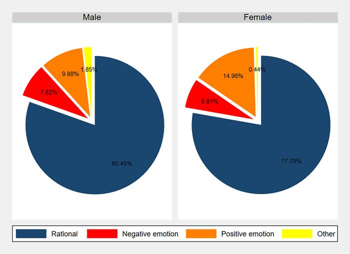
Women are around 40% more generous than men in "Dictator Game" lab experiments measuring generosity, with personality traits and emotions affecting donation decisions
Credit: Barreda-Tarrazona et al., 2025, PLOS One, CC-BY 4.0 (https://creativecommons.org/licenses/by/4.0/)
Women are around 40% more generous than men in "Dictator Game" lab experiments measuring generosity, with personality traits and emotions affecting donation decisions
Article title: Gender differences in dictator giving: A high-power laboratory test
Author countries: Spain
Funding: This work was supported by the Spanish Ministry of Science and Innovation (PID2021-123053OB-I00) and Jaume I University (UJI-B2021-23). The funders had no role in study design, data collection and analysis, decision to publish, or preparation of the manuscript..
A study shows that there are almost twice as many risky days for large human-caused fires in the American West as there are for lightning-caused fires, due to differences in the level of heat and aridity under which each type of fire is likely to occur. The discrepancy is not accounted for in most fire early warning systems. In addition, risky days for human-caused fires are growing faster than risky days for lighting-caused fires as the climate warms.
Fa Li and colleagues focused on Vapor Pressure Deficit (VPD), which captures both dryness and heat, reflecting the difference between the actual air water vapor content and saturation. The authors used a Bayesian inference algorithm to model the relationship between VPD and the probability of large fires for the largest 10% of fires in each ecoregion in the western United States. The estimated VPD threshold for large fires ranged from 1.1 to 2.1 kPa for human-ignited large fires and 1.8 to 3.1 kPa for lightning-ignited large fires. One reason for this difference is likely related to the location of the first ignition. Lightning strikes from above, hitting the forest canopy, which is often living and therefore moist. Human-caused fires often ignite at ground level in dried grass or fine dead branches, material which tends to be very dry. Thus human-caused fires can catch and spread when the atmosphere is wetter. Across the west, from 1979-2020, about 30 days a year were sufficiently hot and dry for lightning-ignited large fires, while about 58 days a year were sufficiently hot and dry for human-ignited large fires. The number of flammable days for human-caused fires increased 21% more rapidly than the number of flammable days for fires caused by lightning over the same period. Anthropogenic greenhouse gas emissions were responsible for 81% of the increases in human-related flammable days. According to the authors, the results can help build more accurate models of fire risk.
flammable days
Mean annual number of flammable days from 1979 to 2020. Each point signifies the mean annual number of flammable days in a grid cell (0.25 degree). The whiskers represent the 5th and 95th quantiles, with boundaries indicating the 25th, 50th, and 75th quartiles.
Credit
Li et al.
Journal
PNAS Nexus
Article Title
Exacerbating risk in human-ignited large fires over western United States due to lower flammability thresholds and greenhouse gas emissions
Article Publication Date
11-Feb-2025
Models show intensifying wildfires in a warming world due to changes in vegetation and humidity; only a minor role for lightning
Global changes in lightning, fires and smoke, expressed per oC global warming. Figure (A) shows the modeled change in lightning flash rate density, (B) the percentage fraction of land burned per year, and (C) the aerosol optical depth changes due to fires, which is an indicator for the amount of smoke in the atmosphere. In the model simulations the amount of CO2 quadruples over a 140-year period with respect to the pre-industrial period; this corresponds to a global mean surface warming of about 4oC.
Extreme fire seasons in recent years highlight the urgent need to better understand wildfires within the broader context of climate change. Under climate change, many drivers of wildfires are expected to change, such as the amount of carbon stored in vegetation, rainfall, and lightning strikes. Quantifying the relative importance of these processes in recent and future wildfire trends has remained challenging, because previous climate computer model simulations did not capture the full coupling between climate change, lightning, wildfires, smoke and corresponding shifts in solar radiation and heat.
A new study published in the journal Science Advances by an international team of climate scientists presents the first realistic supercomputer simulation that resolves the complex interactions between fire, vegetation, smoke and the atmosphere. The authors find that increasing greenhouse gas emissions will likely increase the global lightning frequency by about 1.6% per degree Celsius global warming, with regional hotspots in the eastern United States, Kenya, Uganda and Argentina [Figure 1A]. Locally this could intensify wildfire occurrences. However, the dominant drivers for the growing area burned by fires each year [Figure 1B] remain shifts in global humidity and a more rapid growth of vegetation, which can serve as wildfire fuel.
The study further identifies regions, where the intensification of fires caused by global warming will be most pronounced [Figure 1B]. Among the regions exhibiting the strongest anthropogenic trends in biomass burning are southern and central equatorial Africa, Madagascar, Australia, parts of the Mediterranean and western North-America. “Our results show that with every degree global warming the global mean area burned by fires each year will increase by 14%. This can have substantial effects on ecosystems, infrastructure and human health and livelihoods.” says Dr. Vincent VERJANS, former postdoctoral research fellow at the IBS Center for Climate Physics (now at Barcelona Supercomputing Center) and lead author of the study.
Moreover, the researchers also highlight that with more fires on a global scale, also the levels of fire smoke will increase [Figure 1C]. Smoke plumes emerging from wildfires will have an effect on air pollution and also lead to reduced penetration of sunlight. The latter changes the heat and infrared radiation in the atmosphere. “Our new computer model simulations show for the first time that accounting for these effects in a comprehensive earth system model, can influence regional temperatures. Fire regions and their downwind smoke plume extensions will experience on average somewhat reduced warming due to the solar dimming effect.” says co-author Prof. Christian FRANZKE from the IBS Center for Climate Physics at Pusan National University, South Korea. However, in addition to reducing sunlight (direct aerosol effect) which is accounted for in the new computer simulations, aerosols from biomass burning can also change the formation of clouds (indirect effect). “This part is still somewhat uncertain, and more research needs to be conducted to understand how fires will impact clouds and subsequently surface temperatures,” adds Prof. Franzke.
While this study makes important strides in representing climate-lightning-wildfire interactions in the current generation of Earth System models, it also identifies key aspects that require further consideration. A critical example is the extent to which Arctic wildfires will increase in a warmer world. In their model simulations, the increase in Arctic wildfire activity is weaker than the observed trends in recent years. “This may indicate that current climate models underestimate future Arctic wildfire risks. Among other things, this would have important consequences for predictions of aerosols released from wildfires, which in turn will affect the climate and influence air quality,” says Dr. Vincent VERJANS.
Conceptual figure illustrates the impacts of fire exclusion and suppression on area burned and fire severity in historically frequent-fire North American forests and woodlands represented by the majority of the fire scar sites used in our analysis.
Fewer wildfires burn in North American forests today than in previous centuries, increasing the risk of more severe wildfires, according to research published this week in Nature Communications. The findings may seem counterintuitive, but frequent low-lying surface fires often maintain balance in forests by reducing fuel sources across large areas.
The new study led by the Cooperative Institute for Research in Environmental Sciences (CIRES) at the University of Colorado Boulder and the U.S. Forest Service’s Rocky Mountain Research Station compared wildfire frequency between two time periods: 1984 to 2022 and 1600 to 1880. Scientists analyzed 1,850 tree-ring records in historically burned areas and compared them to maps documenting the perimeters of modern fires across Canada and the United States.
The findings show modern-day fires are much less frequent than they were in past centuries, despite recent record-breaking fire years, such as 2020. The results also reveal that much of the continent is in a substantial “fire deficit,” experiencing about 20 percent as much fire as in the past. On average, larger areas of land burned from fires each year before 1880 compared to 1984-2022. This deficit allows fuel to build up over time, creating conditions for more severe fires.
Even though a much larger portion of the forest burned in fires in the 18th and 19th centuries, those fires were less devastating: the trees that recorded those fires survived and continued to grow. Modern fires, in contrast, are so severe they often leave forests barren and speckled with dead trees.
According to the researchers, the differences between historical and contemporary fires likely reflect the changed relationship between fire, forests, and people across much of the U.S. and Canada. Before 1880, fires burned more frequently but less severely across many forests due to traditional burning practices by Indigenous peoples and lightning-sparked fires. These fires often had a stabilizing effect on the forests by clearing out brush and debris—lowering the amount of flammable forest fuels available.
The disruption of traditional burning practices, widespread livestock grazing, and later suppression of human and lightning-ignited fires have prevented beneficial forest fires from igniting across the U.S over the past century. This has destabilized forests that evolved with and are adapted to fire. Today’s higher-severity wildfires are more likely to harm people and communities while transforming forests into other vegetation types such as shrublands.
Wildfires are inevitable in forests across the Western U.S. There is an ever-growing body of science around practices to help reduce the probability that these fires will have adverse impacts on forests and humans. Previous research shows that activities such as mechanical fuel treatments and prescribed burning are effective ways to reduce fire impacts, and are in line with both Indigenous management practices and long-term ecological processes.
“It’s heartbreaking to witness how recent wildfires are devastating people, communities, and forests,” said Sean Parks, research scientist with the U.S. Forest Service Rocky Mountain Research Station, and lead author of the study. “Wildfires are inevitable, so preparing our forests for these events through fuel reduction treatments and prescribed fire will reduce their impacts to communities and forests.”
Credit: Field Peterson/Colorado State Forest Service
Colorado’s forests store a massive amount of carbon, but dying trees – mostly due to insects and disease – have caused the state’s forests to emit more carbon than they absorbed in recent years, according to a Colorado State Forest Service report.
Trees consume carbon dioxide and lock it away from the atmosphere, preventing the heat-trapping gas from contributing to global warming. However, dead trees slowly release carbon as they decompose.
The report’s findings are valuable as policymakers consider options for drawing down carbon to reduce climate change and forest managers develop long-term strategies for forest and carbon management.
“People are looking to our natural ecosystems to mitigate climate change,” said Tony Vorster, lead author of the report and a research scientist with the Natural Resource Ecology Laboratory. “We shouldn't necessarily look to our forests to offset emissions because they're currently a net carbon source across the state as a whole, and that trend is probably going to continue with ongoing droughts and wildfires.”
Vorster said that future reports will show Colorado’s forests are an even greater source of carbon because of recent severe wildfires that were not accounted for in the report released Jan. 9, which covers 2002-2019.
The state-mandated Forest Carbon Inventory provides the most detailed and comprehensive assessment to date of how much carbon is stored in Colorado’s forests and harvested wood products and how that amount is changing over time.
“It's natural for forests to cycle through times where they are carbon sinks and then carbon sources. We're interested in long-term trends,” Vorster said.
Researchers from the Colorado State Forest Service and the Natural Resource Ecology Laboratory, both part of Colorado State University’s Warner College of Natural Resources, developed a statewide carbon accounting framework to produce the ongoing inventory. The inventory establishes a baseline for measuring future changes, so managers and policymakers can gauge the long-term effectiveness of decisions. It will be updated every few years.
“While other reports have provided estimates for forest carbon, this report stands out as the first to focus solely on the state’s forest sector,” said Ashley Prentice, a CSFS forest carbon specialist and co-author of the report. “It delivers a detailed, in-depth analysis of how much carbon is stored, how it is changing and the factors driving these changes.”
Researchers estimated that Colorado's 22.8 million acres of forests and harvested wood products stored 1,558 teragrams of carbon between 2010 and 2019. (A teragram is one trillion grams or a million metric tons.) To put that into perspective, Prentice said if all that carbon were released, it would be roughly equivalent to annual carbon dioxide emissions from 1.3 billion gas-powered vehicles.
Compared to their total carbon stock, the state’s forests emit a relatively small 0.9 teragrams of carbon annually, Prentice calculated, which is roughly equivalent to the annual carbon dioxide emissions from 770,000 vehicles.
Patchwork of carbon gains and losses
Trees are half carbon. They absorb carbon dioxide through photosynthesis and store it as biomass in their trunks, branches, leaves, roots and in the soil.
This inventory is the first for Colorado to include harvested wood products, like lumber or furniture, which continue to store carbon until they decompose or are burned. Harvested wood contributed only a small fraction of carbon to the state’s overall stock, 0.4%; however, Prentice said, “These products represent an opportunity for long-term carbon storage while also supporting local economies.”
Changes in carbon stocks varied greatly across forest types and locations, in line with disturbances by wildfire, weather, insects, disease and timber harvest.
Insects and disease – most notably, bark beetle outbreaks – affected more forest than wildfire, harvest and weather combined during the study period. Insects and disease were responsible for 85% of the total area impacted by disturbances and 64% of disturbance-related carbon losses.
Undisturbed forests sequestered more carbon than they emitted.
So, can we just plant more trees to make up the difference?
“We're not going to plant our way out of this, but reforestation is a strategy that can be used to reduce the loss of forest and to mitigate some of these carbon losses,” Vorster said.
He stressed that while the inventory is focused on carbon, it is only one of a host of factors forest managers consider, including wildlife, recreation, economics and wildfire risk. He also noted that it’s important to take the long view in carbon management. For example, forest thinning to limit wildfire severity might cost carbon stocks in the short term but could retain more carbon in the long run.
Tree-level tracking
The inventory calculated higher carbon stocks and lower emissions than past estimates, probably due to differences in methodology, Vorster said.
In developing a new inventory framework, CSFS and NREL adapted estimation methods used by West Coast states for the Rocky Mountain region, creating a template that can be used by other states.
The inventory tracks tree-level growth, removal and mortality trends through federal data from the U.S. Forest Service’s Forest Inventory and Analysis program. CSFS surveys Colorado’s FIA plots every 10 years, beginning in 2002, for consistent, long-term data on individual trees. The plots are representative of the state’s overall forested area, on both public and private land, but do not include urban trees. Timber harvest data going back to 1954 was used to determine carbon stock and changes in harvested wood products.
Explore the Forest Carbon Inventory webpage for more information, including a data dashboard, podcast, frequently asked questions and key definitions.
Article Title
Colorado Forest Carbon Inventory: Forest Ecosystem and Harvested Wood Product Carbon Accounting Framework Through 2019