Wednesday, October 02, 2024

SPACE/COSMOLOGY

  Webb telescope reveals surprising details of Pluto's moon Charon


Will Dunham
Tue, October 1, 2024 

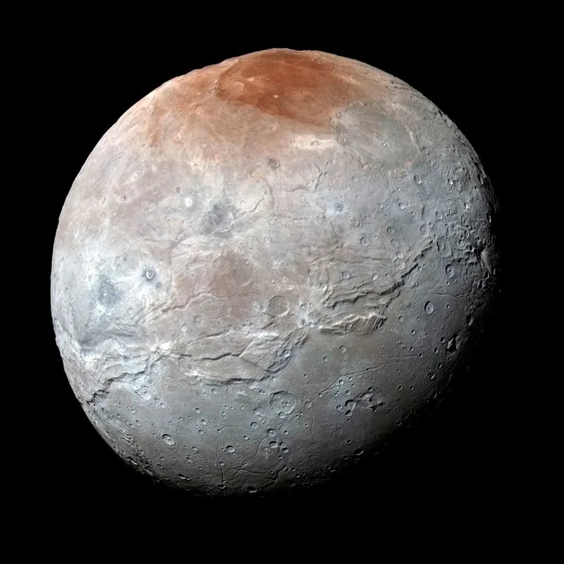
FILE PHOTO: Pluto's largest moon, Charon, is seen in a high-resolution, enhanced color view captured by NASA's New Horizons spacecraft


By Will Dunham

WASHINGTON (Reuters) - Observations by the James Webb Space Telescope are giving scientists a fuller understanding about the composition and evolution of Pluto's moon Charon, the largest moon orbiting any of our solar system's dwarf planets.

Webb for the first time detected carbon dioxide and hydrogen peroxide - both frozen as solids - on the surface of Charon, a spherical body about 750 miles (1,200 km) in diameter, researchers said on Tuesday. Those are added to the water ice, ammonia-bearing compounds and organic materials previously documented on Charon's surface.


Charon, discovered in 1978, has the distinction of being the solar system's largest moon relative in size to the planet it orbits. It is about half the diameter and an eighth the mass of Pluto, a dwarf planet that resides in a frigid region of the outer Solar System called the Kuiper Belt, beyond the most distant planet Neptune.

The distance between Charon and Pluto is about 12,200 miles (19,640 km), compared to the 238,855 miles (384,400 km) on average separating Earth from its moon.

Most of Charon's surface is gray, with reddish-brown regions around its poles composed of organic materials.

The Webb observations build on data obtained when NASA's New Horizons spacecraft flew by Charon during its visit to the Pluto system in 2015. The new study tapped into the ability of Webb, which was launched in 2021 and began collecting data the following year, to observe across a greater range of wavelengths than previously available.

The presence of hydrogen peroxide speaks to the irradiation processes Charon has experienced over time, the researchers said, while the carbon dioxide is probably an original component dating to this moon's formation about 4.5 billion years ago.

The hydrogen peroxide, the researchers said, formed as the water ice on Charon's surface was chemically altered by the perpetual onslaught of ultraviolet radiation from the sun as well as energetic particles from the solar wind and from galactic cosmic rays that traverse the universe.

The researchers said the carbon dioxide observed by Webb was probably buried underneath the surface and exposed by impacts on Charon. The carbon dioxide, they said, is likely to have been part of the primordial material from which both Charon and Pluto originally formed.

Scientists had been surprised that carbon dioxide was not previously spotted.

"The detection of carbon dioxide was a satisfying confirmation of our expectations," said Silvia Protopapa, assistant director of the department of space studies at the Southwest Research Institute in Boulder, Colorado, co-investigator of the New Horizons mission and lead author of the study published in the journal Nature Communications.

"The detection of hydrogen peroxide on Charon was unexpected. I honestly did not anticipate finding evidence of it on the surface," Protopapa added.

The new observations of Charon help tell a broader story about the celestial bodies populating our solar system.

"Every small body in the outer solar system is a unique piece of a larger puzzle that scientists are trying to put together," Protopapa said.

The researchers used a Webb instrument called the Near-Infrared Spectrograph to make four observations in 2022 and 2023, getting full coverage of Charon's northern hemisphere.

"These new Webb observations add carbon dioxide and hydrogen peroxide to the known inventory of (Charon's) surface components. Both of these provide insights into ongoing processes of irradiation and impact-driven resurfacing," said study co-author Ian Wong, staff scientist at the Space Telescope Science Institute in Baltimore.

(Reporting by Will Dunham, Editing by Rosalba O'Brien)


Grounded Astronauts Angry They Were Forced to Give Up Their Seats for Stranded Starliner Crew


Victor Tangermann
Wed, October 2, 2024 


Grounded

NASA astronauts Zena Cardman and Stephanie Wilson were intending to get a lift to the International Space Station on board a SpaceX Crew Dragon spacecraft over the weekend.

But thanks to Boeing's disastrous crewed test flight of its issues-laden Starliner spacecraft, the two women had to stay behind to make space for their stranded colleagues, Butch Wilmore and Suni Williams.

Wilmore and Williams, who have been stuck on board the ISS since June and had to wave their Starliner ride goodbye as it made its reentry without them last month, will take Cardman and Wilson's seats in February instead.

"I think it was hard not to watch that rocket lift off without thinking, 'That's my rocket and that's my crew,'" Cardman said during NASA's live broadcast of Saturday's Crew-9 launch, as quoted by Space.com. "It makes me feel very connected to this mission."
Hate to Watch You Leave

Two out of the four seats on board the Crew Dragon were occupied by NASA astronaut Nick Hague and cosmonaut Aleksandr Gorbunov, who will be returning alongside Wilmore and Williams early next year.

Hague has been on two trips to the ISS, while Gorbunov is on his first flight to space. Cardman has yet to visit the ISS, while Wilson flew to space onboard three Space Shuttle missions between 2006 and 2010.

It must've been a bittersweet moment, watching the two leave without Cardman or Wilson on board. After all, an opportunity to launch into space is exceedingly rare.

"We, of course, want to be together," Wilson said during the broadcast. "We have built friendship and camaraderie … but I'm very excited for them, looking forward to hearing their stories from space."

To balance out the weight, Cardman and Wilson's bodies were simulated using pieces of ballast inside the Crew Dragon capsule.

Cardman applauded NASA for prioritizing the "safety of the crew," and added that Williams and Wilmore were "well-prepared" professionals.

In late August, NASA made the decision to bump the two women from the flight. Instead, they had to watch their colleagues get ready over many weeks, an unfortunate reality brought about by Boeing's plagued Starliner.

"Zena and Stephanie will continue to assist their crewmates ahead of launch," NASA chief astronaut Joe Acaba said in a statement at the time. "They exemplify what it means to be a professional astronaut."

More on Starliner: NASA Almost Gave All Its Crew Funding to Boeing's Disastrous Starliner, Leaving SpaceX Out in the Cold


NASA switches off instrument on Voyager 2 spacecraft to save power

ADITHI RAMAKRISHNAN
Wed, October 2, 2024 at 9:18 AM MDT·1 min read
60


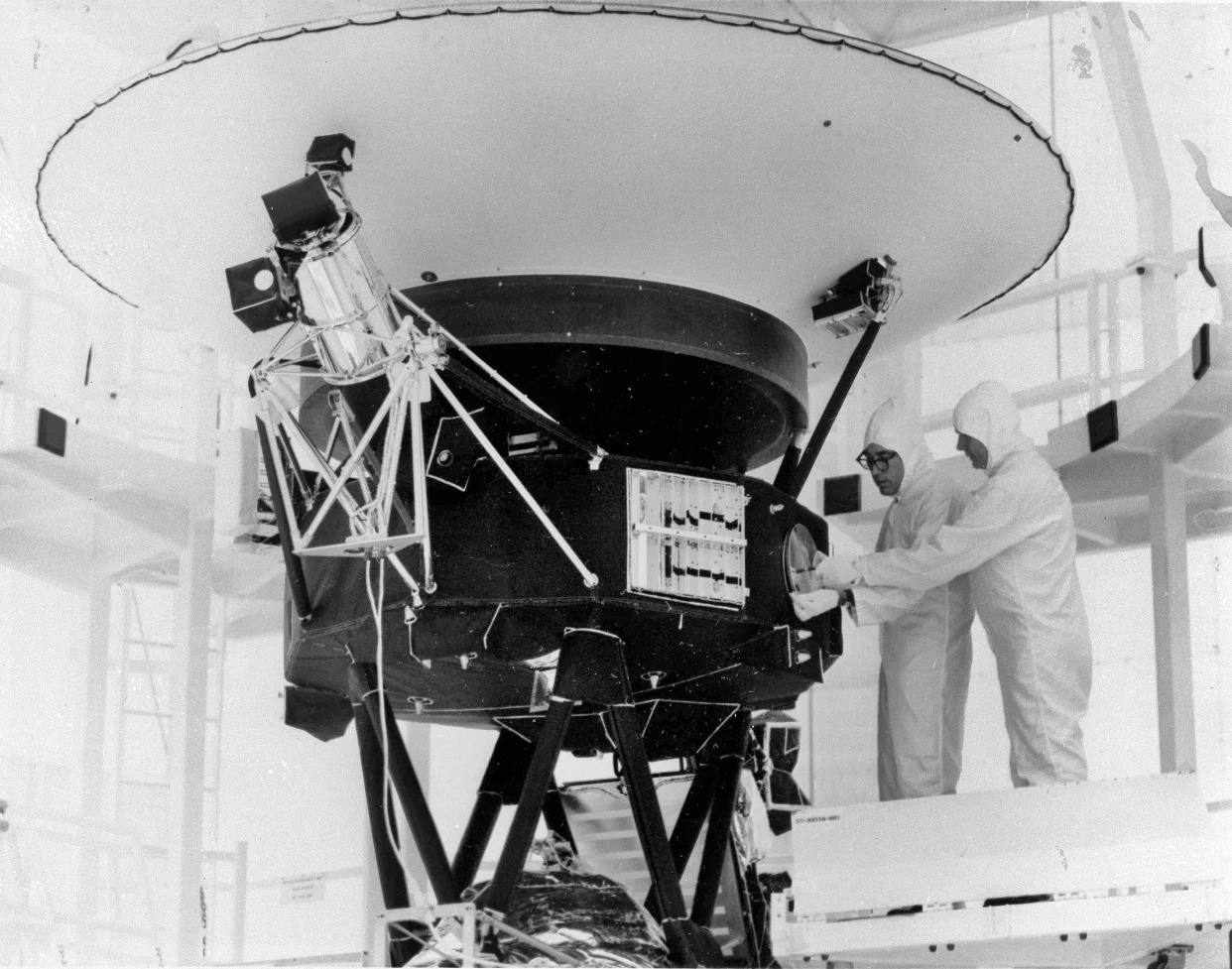
FILE - This photo provided by NASA shows the "Sounds of Earth" record being mounted on the Voyager 2 spacecraft in the Safe-1 Building at the Kennedy Space Center, Fla. Aug. 4, 1977. (AP Photo/NASA, File)

NEW YORK (AP) — To save power, NASA has switched off another scientific instrument on its long-running Voyager 2 spacecraft.

The space agency said Tuesday that Voyager 2's plasma science instrument — designed to measure the flow of charged atoms — was powered down in late September so the spacecraft can keep exploring for as long as possible, expected into the 2030s.

NASA turned off a suite of instruments on Voyager 2 and its twin Voyager 1 after they explored the gas giant planets in the 1980s. Both are currently in interstellar space, or the space between stars. The plasma instrument on Voyager 1 stopped working long ago and was finally shut down in 2007.

Four remaining instruments on Voyager 2 will continue collecting information about magnetic fields and particles. Its goal is to study the swaths of space beyond the sun's protective bubble.

Launched in 1977, Voyager 2 is the only spacecraft to visit Uranus and Neptune. It's currently more than 12 billion miles (19.31 billion kilometers) from Earth. Voyager 1 is over 15 billion miles (24.14 billion kilometers) from Earth.

___

The Associated Press Health and Science Department receives support from the Howard Hughes Medical Institute’s Science and Educational Media Group. The AP is solely responsible for all content.


NASA astronaut snaps footage of glorious comet flying through space

Mashable
Tue, October 1, 2024

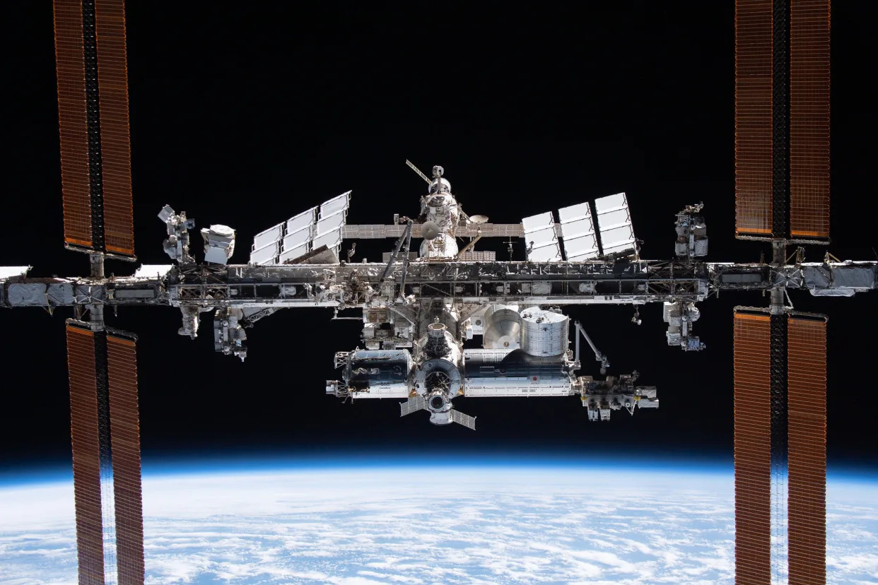
The International Space Station viewed from a SpaceX Dragon craft.


An icy visitor is flying through the inner solar system.

Comet Tsuchinshan-ATLAS, also called Comet C/2023 A3, has grown brighter as it's approached the sun, allowing astronauts aboard the International Space Station to capture vivid footage of this ancient ball of ice, rock, and dust. NASA astronaut Matthew Dominick recently posted a view of the comet rising beyond Earth as the station zipped through its orbit at some 17,500 mph.

"Comet rises above the horizon just before orbital sunrise amongst aurora and swirling satellites," the space agency's flight engineer posted online. The comet makes its appearance at the bottom of the view at about 12 seconds into the short clip.

SEE ALSO: NASA scientist viewed first Voyager images. What he saw gave him chills.

In this view from Sept. 29, the comet is some 75 million miles from Earth, and 38 million miles from the sun (Earth is 93 million miles from our star). As comets approach the sun, they heat up and eject dust and gas into space, leaving long wakes of millions-of-miles-long material, as you can see below. Comet C/2023 A3 just made its closest approach to the sun on Sept. 27, and is now en route to the profoundly frigid realms of the deep solar system.


Comets have a lot of material to burn, as they're typically miles long to tens of miles long. "When frozen, they are the size of a small town," NASA explained. One particular comet, discovered in 2021, is a whopping 85 miles wide.

Although Dominick captured the comet with a camera, he did note that it's visible to the naked eye from the space station, too. And down on Earth, it might be visible to skygazers. The "best show," as the comet zooms between Earth and the sun, is likely to happen in mid-October.

But if this comet eludes you, or you can't escape to dark enough skies, enjoy the view from space.

NASA’s TESS spots record-breaking stellar triplets


NASA/Goddard Space Flight Center
TIC 290061484 System 

image: 

This artist’s concept illustrates how tightly the three stars in the system called TIC 290061484 orbit each other. If they were placed at the center of our solar system, all the stars’ orbits would be contained a space smaller than Mercury’s orbit around the Sun. The sizes of the triplet stars and the Sun are also to scale.

view more 

Credit: NASA’s Goddard Space Flight Center


Professional and amateur astronomers teamed up with artificial intelligence to find an unmatched stellar trio called TIC 290061484, thanks to cosmic “strobe lights” captured by NASA’s TESS (Transiting Exoplanet Survey Satellite)

The system contains a set of twin stars orbiting each other every 1.8 days, and a third star that circles the pair in just 25 days. The discovery smashes the record for shortest outer orbital period for this type of system, set in 1956, which had a third star orbiting an inner pair in 33 days.

“Thanks to the compact, edge-on configuration of the system, we can measure the orbits, masses, sizes, and temperatures of its stars,” said Veselin Kostov, a research scientist at NASA’s Goddard Space Flight Center in Greenbelt, Maryland, and the SETI Institute in Mountain View, California. “And we can study how the system formed and predict how it may evolve.”

A paper, led by Kostov, describing the results was published in The Astrophysical Journal Oct. 2.

Flickers in starlight helped reveal the tight trio, which is located in the constellation Cygnus. The system happens to be almost flat from our perspective. This means the stars each cross right in front of, or eclipse, each other as they orbit. When that happens, the nearer star blocks some of the farther star’s light.

Using machine learning, scientists filtered through enormous sets of starlight data from TESS to identify patterns of dimming that reveal eclipses. Then, a small team of citizen scientists filtered further, relying on years of experience and informal training to find particularly interesting cases.

These amateur astronomers, who are co-authors on the new study, met as participants in an online citizen science project called Planet Hunters, which was active from 2010 to 2013. The volunteers later teamed up with professional astronomers to create a new collaboration called the Visual Survey Group, which has been active for over a decade.

“We’re mainly looking for signatures of compact multi-star systems, unusual pulsating stars in binary systems, and weird objects,” said Saul Rappaport, an emeritus professor of physics at MIT in Cambridge. Rappaport co-authored the paper and has helped lead the Visual Survey Group for more than a decade. “It’s exciting to identify a system like this because they’re rarely found, but they may be more common than current tallies suggest.” Many more likely speckle our galaxy, waiting to be discovered.

Partly because the stars in the newfound system orbit in nearly the same plane, scientists say it’s likely very stable despite their tight configuration (the trio’s orbits fit within a smaller area than Mercury’s orbit around the Sun). Each star’s gravity doesn’t perturb the others too much, like they could if their orbits were tilted in different directions.

But while their orbits will likely remain stable for millions of years, “no one lives here,” Rappaport said. “We think the stars formed together from the same growth process, which would have disrupted planets from forming very closely around any of the stars.” The exception could be a distant planet orbiting the three stars as if they were one.

As the inner stars age, they will expand and ultimately merge, triggering a supernova explosion in around 20 to 40 million years.

In the meantime, astronomers are hunting for triple stars with even shorter orbits. That’s hard to do with current technology, but a new tool is on the way.

Images from NASA’s upcoming Nancy Grace Roman Space Telescope will be much more detailed than TESS’s. The same area of the sky covered by a single TESS pixel will fit more than 36,000 Roman pixels. And while TESS took a wide, shallow look at the entire sky, Roman will pierce deep into the heart of our galaxy where stars crowd together, providing a core sample rather than skimming the whole surface.

“We don’t know much about a lot of the stars in the center of the galaxy except for the brightest ones,” said Brian Powell, a co-author and data scientist at Goddard. “Roman’s high-resolution view will help us measure light from stars that usually blur together, providing the best look yet at the nature of star systems in our galaxy.”

And since Roman will monitor light from hundreds of millions of stars as part of one of its main surveys, it will help astronomers find more triple star systems in which all the stars eclipse each other.

“We’re curious why we haven’t found star systems like these with even shorter outer orbital periods,” said Powell. “Roman should help us find them and bring us closer to figuring out what their limits might be.”

Roman could also find eclipsing stars bound together in even larger groups — half a dozen, or perhaps even more all orbiting each other like bees buzzing around a hive.

“Before scientists discovered triply eclipsing triple star systems, we didn’t expect them to be out there,” said co-author Tamás Borkovits, a senior research fellow at the Baja Observatory of The University of Szeged in Hungary. “But once we found them, we thought, well why not? Roman, too, may reveal never-before-seen categories of systems and objects that will surprise astronomers.”

TESS is a NASA Astrophysics Explorer mission managed by NASA Goddard and operated by MIT in Cambridge, Massachusetts. Additional partners include Northrop Grumman, based in Falls Church, Virginia; NASA’s Ames Research Center in California’s Silicon Valley; the Center for Astrophysics | Harvard & Smithsonian in Cambridge, Massachusetts; MIT’s Lincoln Laboratory; and the Space Telescope Science Institute in Baltimore. More than a dozen universities, research institutes, and observatories worldwide are participants in the mission.

NASA’s citizen science projects are collaborations between scientists and interested members of the public and do not require U.S. citizenship. Through these collaborations, volunteers (known as citizen scientists) have helped make thousands of important scientific discoveries. To get involved with a project, visit NASA’s Citizen Science page.

Scientists discover planet orbiting closest single star to our Sun


ESO
Artist’s impression of a sub-Earth-mass planet orbiting Barnard’s star 

image: 

This artist’s impression shows Barnard b, a sub-Earth-mass planet that was discovered orbiting Barnard’s star. Its signal was detected with the ESPRESSO instrument on ESO’s Very Large Telescope (VLT), and astronomers were able to confirm it with data from other instruments. An earlier promising detection in 2018 around the same star could not be confirmed by these data. On this newly discovered exoplanet, which has at least half the mass of Venus but is too hot to support liquid water, a year lasts just over three Earth days.

view more 

Credit: ESO/M. Kornmesser


Using the European Southern Observatory’s Very Large Telescope (ESO’s VLT), astronomers have discovered an exoplanet orbiting Barnard’s star, the closest single star to our Sun. On this newly discovered exoplanet, which has at least half the mass of Venus, a year lasts just over three Earth days. The team’s observations also hint at the existence of three more exoplanet candidates, in various orbits around the star.

Located just six light-years away, Barnard’s star is the second-closest stellar system — after Alpha Centauri’s three-star group — and the closest individual star to us. Owing to its proximity, it is a primary target in the search for Earth-like exoplanets. Despite a promising detection back in 2018, no planet orbiting Barnard's star had been confirmed until now.

The discovery of this new exoplanet — announced in a paper published today in the journal Astronomy & Astrophysics — is the result of observations made over the last five years with ESO’s VLT, located at Paranal Observatory in Chile. “Even if it took a long time, we were always confident that we could find something,” says Jonay González Hernández, a researcher at the Instituto de Astrofísica de Canarias in Spain, and lead author of the paper. The team were looking for signals from possible exoplanets within the habitable or temperate zone of Barnard’s star — the range where liquid water can exist on the planet’s surface. Red dwarfs like Barnard’s star are often targeted by astronomers since low-mass rocky planets are easier to detect there than around larger Sun-like stars. [1]

Barnard b [2], as the newly discovered exoplanet is called, is twenty times closer to Barnard’s star than Mercury is to the Sun. It orbits its star in 3.15 Earth days and has a surface temperature around 125 °C. “Barnard b is one of the lowest-mass exoplanets known and one of the few known with a mass less than that of Earth. But the planet is too close to the host star, closer than the habitable zone,” explains González Hernández. “Even if the star is about 2500 degrees cooler than our Sun, it is too hot there to maintain liquid water on the surface.

For their observations, the team used ESPRESSO, a highly precise instrument designed to measure the wobble of a star caused by the gravitational pull of one or more orbiting planets. The results obtained from these observations were confirmed by data from other instruments also specialised in exoplanet hunting: HARPS at ESO’s La Silla Observatory, HARPS-N and CARMENES. The new data do not, however, support the existence of the exoplanet reported in 2018. 

In addition to the confirmed planet, the international team also found hints of three more exoplanet candidates orbiting the same star. These candidates, however, will require additional observations with ESPRESSO to be confirmed. “We now need to continue observing this star to confirm the other candidate signals,” says Alejandro Suárez Mascareño, a researcher also at the Instituto de Astrofísica de Canarias and co-author of the study. “But the discovery of this planet, along with other previous discoveries such as Proxima b and d, shows that our cosmic backyard is full of low-mass planets.”

ESO’s Extremely Large Telescope (ELT), currently under construction, is set to transform the field of exoplanet research. The ELT’s ANDES instrument will allow researchers to detect more of these small, rocky planets in the temperate zone around nearby stars, beyond the reach of current telescopes, and enable them to study the composition of their atmospheres.

Notes

[1] Astronomers target cool stars, like red dwarfs, because their temperate zone is much closer to the star than that of hotter stars, like the Sun. This means that the planets orbiting within their temperate zone have shorter orbital periods, allowing astronomers to monitor them over several days or weeks, rather than years. In addition, red dwarfs are much less massive than the Sun, so they are more easily disturbed by the gravitational pull of the planets around them and thus they wobble more strongly. 

[2] It’s common practice in science to name exoplanets by the name of their host star with a lowercase letter added to it, ‘b’ indicating the first known planet, ’c’ the next one, and so on. The name Barnard b was therefore also given to a previously suspected planet candidate around Barnard's star, which scientists were unable to confirm.

More information

This research was presented in the paper “A sub-Earth-mass planet orbiting Barnard’s star” to appear in Astronomy & Astrophysics. (https://www.aanda.org/10.1051/0004-6361/202451311)

The team is composed of J. I. González Hernández (Instituto de Astrofísica de Canarias, Spain [IAC] and Departamento de Astrofísica, Universidad de La Laguna, Spain [IAC-ULL]), A. Suárez Mascareño (IAC and IAC-ULL), A. M. Silva (Instituto de Astrofísica e Ciências do Espaço, Universidade do Porto, Portugal [IA-CAUP] and Departamento de Física e Astronomia Faculdade de Ciências, Universidade do Porto, Portugal [FCUP]), A. K. Stefanov (IAC and IAC-ULL), J. P. Faria (Observatoire de Genève, Université de Genève, Switzerland [UNIGE]; IA-CAUP and FCUP), H. M. Tabernero (Departamento de Física de la Tierra y Astrofísica & Instituto de Física de Partículas y del Cosmos, Universidad Complutense de Madrid, Spain), A. Sozzetti (INAF - Osservatorio Astrofisico di Torino [INAF-OATo] and Istituto Nazionale di Astrofisica, Torino, Italy), R. Rebolo (IAC; IAC-ULL and Consejo Superior de Investigaciones Científicas, Spain [CSIC]), F. Pepe (UNIGE), N. C. Santos (IA-CAUP; FCUP), S. Cristiani (INAF - Osservatorio Astronomico di Trieste, Italy [INAF-OAT] and Institute for Fundamental Physics of the Universe, Trieste, Italy [IFPU]), C. Lovis (UNIGE), X. Dumusque (UNIGE), P. Figueira (UNIGE and IA-CAUP), J. Lillo-Box (Centro de Astrobiología, CSIC-INTA, Madrid, Spain [CAB]), N. Nari (IAC; Light Bridges S. L., Canarias, Spain and IAC-ULL), S. Benatti (INAF - Osservatorio Astronomico di Palermo, Italy [INAF-OAPa]), M. J. Hobson (UNIGE), A. Castro-González (CAB), R. Allart (Institut Trottier de Recherche sur les Exoplanètes, Université de Montréal, Canada and UNIGE), V. M. Passegger (National Astronomical Observatory of Japan, Hilo, USA; IAC; IAC-ULL and Hamburger Sternwarte, Hamburg, Germany), M.-R. Zapatero Osorio (CAB), V. Adibekyan (IA-CAUP and FCUP), Y. Alibert (Center for Space and Habitability, University of Bern, Switzerland and Weltraumforschung und Planetologie, Physikalisches Institut, University of Bern, Switzerland), C. Allende Prieto (IAC and IAC-ULL), F. Bouchy (UNIGE), M. Damasso (INAF-OATo), V. D’Odorico (INAF-OAT and IFPU), P. Di Marcantonio (INAF-OAT), D. Ehrenreich (UNIGE), G. Lo Curto (European Southern Observatory, Santiago, Chile [ESO Chile]), R. Génova Santos (IAC and IAC-ULL), C. J. A. P. Martins (IA-CAUP and Centro de Astrofísica da Universidade do Porto, Portugal), A. Mehner (ESO Chile), G. Micela (INAF-OAPa), P. Molaro (INAF-OAT), N. Nunes (Instituto de Astrofísica e Ciências do Espaço, Universidade de Lisboa), E. Palle (IAC and IAC-ULL), S. G. Sousa (IA-CAUP and FCUP), and S. Udry (UNIGE).

The European Southern Observatory (ESO) enables scientists worldwide to discover the secrets of the Universe for the benefit of all. We design, build and operate world-class observatories on the ground — which astronomers use to tackle exciting questions and spread the fascination of astronomy — and promote international collaboration for astronomy. Established as an intergovernmental organisation in 1962, today ESO is supported by 16 Member States (Austria, Belgium, Czechia, Denmark, France, Finland, Germany, Ireland, Italy, the Netherlands, Poland, Portugal, Spain, Sweden, Switzerland and the United Kingdom), along with the host state of Chile and with Australia as a Strategic Partner. ESO’s headquarters and its visitor centre and planetarium, the ESO Supernova, are located close to Munich in Germany, while the Chilean Atacama Desert, a marvellous place with unique conditions to observe the sky, hosts our telescopes. ESO operates three observing sites: La Silla, Paranal and Chajnantor. At Paranal, ESO operates the Very Large Telescope and its Very Large Telescope Interferometer, as well as survey telescopes such as VISTA. Also at Paranal ESO will host and operate the Cherenkov Telescope Array South, the world’s largest and most sensitive gamma-ray observatory. Together with international partners, ESO operates ALMA on Chajnantor, a facility that observes the skies in the millimetre and submillimetre range. At Cerro Armazones, near Paranal, we are building “the world’s biggest eye on the sky” — ESO’s Extremely Large Telescope. From our offices in Santiago, Chile we support our operations in the country and engage with Chilean partners and society. 

Links

Generating water on-demand in extreme environments, including other planets


By Dr. Tim Sandle
DIGITAL JOURNAL
October 1, 2024


This handout image taken by NASA's Mars rover Curiosity shows rippled patterns on the surface of rocks caused by the waves of a shallow lake billions of years ago - Copyright AFP Zein Al RIFAI


For first time, researchers witnessed formation of nanosized water bubbles in real time and at the molecular-scale. Here, the scientists observed hydrogen and oxygen atoms merge to form tiny, nano-sized bubbles of water. This demonstrated how palladium, a rare metallic element, can rapidly generate water from hydrogen and oxygen. The element catalyzes the gaseous reaction to generate water.

Since the early 1900s, researchers have known that palladium can act as a catalyst to rapidly generate water. But how, exactly, this reaction occurs has remained a mystery. Viewing the process with atomic precision was simply impossible, at least until nine months ago.

The researchers from Northwestern University witnessed this process at the nanoscale for the first time with an electron microscope. By viewing the process with extreme precision, they discovered how to optimize it to generate water at a faster rate.

The new process could be used to generate water on-demand in extreme environments, including on other planets. This is useful since the reaction does not require extreme conditions; hence, the researchers say it could be harnessed as a practical solution for rapidly generating water in arid environments.

For the experiment, the scientists developed an ultra-thin glassy membrane that holds gas molecules within honeycomb-shaped nanoreactors, so they can be viewed within high-vacuum transmission electron microscopes.

Here the researchers can examine samples in atmospheric pressure gas at a resolution of just 0.102 nanometers, compared to a 0.236-nanometer resolutionusing other state-of-the-art tools. The technique also enabled, for the first time, concurrent spectral and reciprocal information analysis.

The researchers think their observation might be the smallest bubble ever formed that has been viewed directly. A process called electron energy loss spectroscopy, to analyze the bubbles.

“By directly visualizing nanoscale water generation, we were able to identify the optimal conditions for rapid water generation under ambient conditions,” states Northwestern’s Vinayak Dravid, senior author of the study. “These findings have significant implications for practical applications, such as enabling rapid water generation in deep space environments using gases and metal catalysts, without requiring extreme reaction conditions.”

Dravid adds: “Think of Matt Damon’s character, Mark Watney, in the movie ‘The Martian.’ He burned rocket fuel to extract hydrogen and then added oxygen from his oxygenator. Our process is analogous, except we bypass the need for fire and other extreme conditions. We simply mixed palladium and gases together.”

The research has been published in the Proceedings of the National Academy of Sciences. The study is titled “Unraveling the adsorption-limited hydrogen oxidation reaction at palladium surface via in situ electron microscopy”.


Apple may need to turn to China after Indian Tata plant fire, sources say
Tata iPhone component plant disrupted by fire


Tue, October 1, 2024 
By Munsif Vengattil

BENGALURU (Reuters) - Extensive damage from a fire at Tata Group's Apple iPhone component plant in southern India could hamper production ahead of a festive season sales surge, an industry watcher and a source said, forcing the U.S. firm's suppliers to arrange critical parts from China or elsewhere.

The weekend blaze has caused an indefinite production halt at Tata's Hosur plant in Tamil Nadu, the only Indian supplier of iPhone back panels and some other parts for both contract manufacturer Foxconn in the country and its own iPhone assembly at another plant.


Hong Kong-based Counterpoint Research told Reuters it estimates local sales of 1.5 million units of iPhone 14 and 15 models during the Indian festive season which runs from late October to early November, with Apple struggling to fulfil as much as 15% of that demand due to the fire.

"There will be a 10-15% impact on production of older iPhone models from India. Apple could offset that impact by importing more components, and by re-routing more export inventory towards India," said Neil Shah, a co-founder of Counterpoint, which has for years tracked Apple's global shipments.

Apart from local sales, Tata, one of India's biggest conglomerates, also exported iPhones to the Netherlands and United States as well as some parts to China, worth more than $250 million overall, in the year to Aug. 31, commercially available customs data shows.

Tata declined to comment.

Apple suppliers typically carry a three- to four-week stock of back panels, Counterpoint said. An industry source with direct knowledge of the matter estimated, however, that Apple was likely to have stock for eight weeks, and therefore would not see an immediate impact.

However, they added that if the production suspension continues, the U.S. company could set up another assembly line in China or add shifts there to secure parts for India's iPhone manufacturers.


Supply chain disruptions more generally have cast a shadow over Prime Minister Narendra Modi's drive to attract foreign investors to "Make in India", especially in the electronics sector.

Apple has been diversifying beyond China but last year separate fire incidents in India caused suppliers Foxlink and Pegatron to briefly halt operations, with authorities finding much of the fire safety equipment at Foxlink's facility was not functional. Contractors Wistron and Foxconn have also been hit by labour unrest in recent years.

"These are temporary setbacks," said Prabhu Ram, vice president at Cybermedia Research. "Continued efforts to improve safety and operational standards are crucial for strengthening India's position as an emerging global electronics manufacturing hub."


Tata is among Apple's newest suppliers in India, which analysts estimate will contribute 20-25% of total global iPhone shipments this year, up from 12-14% last year.

The fire-hit plant employed 20,000 workers. Another unit in the same Tata complex was due to start making complete iPhones later this year and it is unclear if the incident will cause this to be delayed.

Tata has another iPhone plant near Bengaluru, which it acquired from Wistron last year, and a second one in Tamil Nadu near Chennai, which it is set to acquire from Pegatron.

(Reporting by Munsif Vengattil in Bengaluru; Editing by Aditya Kalra, Kirsten Donovan)

 Opinion


Fox News Pushes Dangerous (and Stupid) Hurricane Helene Conspiracy

Edith Olmsted
Tue, October 1, 2024 


Fox News’s Laura Ingraham has started pushing a wild conspiracy theory about the federal response to Hurricane Helene that seems copy-pasted from another natural disaster.

Ingraham hosted a segment speculating Monday night about what a strong leader Donald Trump would have been during the aftermath of Hurricane Helene, and criticizing President Joe Biden and Vice President Kamala Harris for their disaster response in North Carolina.

Ingraham also reignited an old conspiracy theory when criticizing Secretary of Transportation Pete Buttegieg, who, she remarked, “loves to go on TV campaigning for Kamala every five minutes.”

“But when will he go on TV to tell us when I-40 is gonna open? Or how many bridges are going to have to be totally rebuilt?” Ingraham sneered.

“Will they drop all their DEI regulations—any that still exist—to ensure that people get the help they need as fast as possibly, as possible?” Ingraham said.

Here, Ingraham’s claim seems to come out of nowhere, and it’s unclear what “DEI regulations” she imagines would prevent the distribution of aid or the rebuilding of vital infrastructure. Of course, DEI is something of a right-wing catch-all for any perceived institutional failure.

Seconds later, Ingraham ironically noted that a “delayed show of concern by our president and vice president has bred its own conspiracy theories.”

If blaming a natural disaster response on wokeness sounds familiar, that’s because it is.

In August 2023, voices on the far-right, including then-presidential candidate Vivek Ramaswamy and Turning Point USA’s Charlie Kirk, tried to spread a conspiracy theory that the local response to the wildfires in Maui had been weakened by the “DEI agenda.”

This comparison seems to have been exactly what Ingraham was going for, because during the same program Monday, Ingraham was joined by former Hawaii Representative Tulsi Gabbard, who has taken a sharp rightward turn since her Democratic run for president in 2020 to become a member of Trump’s campaign team.

Ingraham and Gabbard both likened the severe flooding in North Carolina to the devastating wildfires in Maui in August of 2023, and criticized the federal response based on… what exactly?

Gabbard claimed that some of her friends in Asheville and the surrounding areas said they had been experiencing the “same thing that happened to our communities in West Maui.” She said her friends “did not see a single federal official on the ground, not even a FEMA orange-vest wearing person.” Gabbard also insisted that the federal government was “focusing on bureaucracy.”

But shaky, sourceless reporting like Gabbard’s secondhand accounts is par for the course for Fox News. In August, host Maria Bartiromo repeatedly claimed that Democrats have been pushing to register “massive lines of illegals” to vote in Texas, but she never did any actual reporting to confirm that topic.

FEMA reported Monday that it had delivered about one million liters of water and more than 600,000 meals across North Carolina, according to NBC News. Residents and local officials have criticized the government for not being adequately prepared to deal with the severity of the destruction in Asheville, which was recently dubbed a “climate haven.”
Health risks are rising in mountain areas flooded by Hurricane Helene and cut off from clean water, power and hospitals

Jennifer Horney, University of Delaware
Tue, October 1, 2024 
THE CONVERSATION


Flooding across North Carolina's mountains left many residents with muddy, debris-strewn yards and flooded homes Melissa Sue Gerrits/Getty Images


Hurricane Helene’s flooding has subsided, but health risks are growing in hard-hit regions of the North Carolina mountains, where many people lost access to power and clean water.

More than 150 deaths across the Southeast had been attributed to Hurricane Helene within days of the late September 2024 storm, according to The Associated Press, and hundreds of people remained unaccounted for. In many areas hit by flooding, homes were left isolated by damaged roads and bridges. Phone service was down. And electricity was likely to be out for weeks.

As a disaster epidemiologist and a native North Carolinian, I have been hearing stories from the region that are devastating. Contaminated water is one of the leading health risks, but residents also face harm to mental health, stress that exacerbates chronic diseases and several other threats.

Water risks: What you can’t see can hurt you

Access to clean water is one of the most urgent health concerns after a flood. People need water for drinking, preparing food, cleaning, bathing, even flushing toilets. Contact with contaminated water can cause serious illnesses.

Floodwater with sewage or other harmful contaminants in it can lead to infectious diseases, particularly among people who are already ill, immunocompromised or have open wounds. Even after the water recedes, residents may underestimate the potential for contamination by unseen bacteria such as fecal coliform, heavy metals such as lead, and organic and inorganic contaminants such as pesticides.


People wait in long lines in Fletcher, N.C., on Sept. 29, 2024, for gasoline to run generators after Hurricane Helene cut power across the mountain region. Sean Rayford/Getty Images

In Asheville, the flooding caused so much damage to water treatment facilities and pipes that officials warned the city could be without running water for potentially weeks. Most private wells also require electricity to pump and filter the water, and many people in surrounding areas could be without power for weeks.

State and federal agencies began delivering extra bottled water to the region shortly after the storm, but supplies were limited, and it’s likely that a number of people won’t be able to reach the distribution sites soon. Access to fresh food is another concern for many areas with roads and bridges washed out.

Inside homes, floodwater can create more health risks, particularly if mold grows on wet fabrics and wallboard. Standing water outside also increases the risk of exposure to mosquitoes carrying diseases such as West Nile virus. Mosquitoes are still active in much of the region in the fall.
Inundation, isolation and access to health care

Many of the images in the news after the hurricane hit showed roads, hospitals and entire towns inundated by floodwaters. In North Carolina, more than 400 roads were closed, blocking access to the major regional health care hub of Asheville, as well as many smaller communities.

While supplies can be airlifted to clinics, residents needing urgent access to treatments such as dialysis or daily medications for substance use disorders may have been cut off. Health care workers may be unable to access their clinics as well.

Flooding in homes can create conditions for mold to grow, even after the mud and water have been cleaned up. Melissa Sue Gerrits/Getty Images

Cuts and other injuries are common in the aftermath of storms, as people clean up debris, and even small wounds can become infected. The stress, exertion and exposure to heat can also exacerbate chronic conditions such as cardiovascular and respiratory diseases.
Mental health and long-term effects

Beyond the risks to physical health, the fear, stress and losses can affect mental health.

Research has consistently shown that emergency responders’ mental health can suffer in widespread disasters, particularly when they know disaster victims, deal with severe injuries or feel helpless. All of those conditions were present as Hurricane Helene’s floodwaters swept away dozens of people, with many more still listed as missing.


Fast-moving floodwaters from Helene washed out roads and bridges across western North Carolina, including this bridge on Highway 22 near North Cove. Photo by Julia Wall for The Washington Post via Getty Images

Stigma, cost and a lack of mental health care providers all add to the ongoing challenges to mental health after disasters. Research shows that a large percentage of people face mental health challenges after disasters.

According to the Substance Abuse and Mental Health Services Administration, two federal grant programs provide mental health services support to individuals and communities after disasters. However, one of those sources of funding ends after 60 days, the other after one year. Given the decades of recovery facing western North Carolina after Hurricane Helene, I believe these programs are woefully inadequate to meet the mental health needs of the populations affected by the storm.
Flooded regions will need long-term help

Western North Carolina is often described as a “climate refuge” because of its cooler summers. And Asheville in particular has become a popular place for retirees and new residents. Recent data shows the city has the second highest migration rate in the nation.

But Helene and other extreme storms that have flooded the region make its vulnerabilities clear.

In the aftermath of the flooding, newcomers unfamiliar with the risks and longtime residents alike will be dealing with ongoing health concerns as they try to clean up and rebuild from the storm. Even as attention shifts to other disasters, the people in this region will still need help to recover for months and years to come.

This article is republished from The Conversation, a nonprofit, independent news organization bringing you facts and trustworthy analysis to help you make sense of our complex world. It was written by: Jennifer HorneyUniversity of Delaware

Read more:

In storms like Hurricane Helene, flooded industrial sites and toxic chemical releases are a silent and growing threat

Hurricane Helene power outages leave millions in the dark – history shows poorer areas often wait longest for electricity to be restored

Hurricanes don’t stop at the coast – these mountain towns know how severe inland flood damage can be, and they’re watching Helene

Jennifer Horney receives funding from National Institute of Standards and Technology (NIST), National Science Foundation (NSF), Centers for Disease Control and Prevention (CDC), National Institute of Environmental Health Sciences (NIEHS), Health Resources and Service Administration (HRSA), Delaware SeaGrant, Delaware Department of Transportation and Delaware Division of Public Health


Helene flooding damages Mountain Island Lake homes. Some blame Duke Energy for it


Gavin Off
Wed, October 2, 2024


Few people in Mecklenburg County suffered more from Hurricane Helene than residents whose homes border the Catwaba River south of Mountain Island Lake.

Floodwater there covered streets. It gushed into homes and filled backyard out buildings with near ceiling-level brown water. A preliminary assessment found four homes to be total losses, said Paige Grande, a spokesperson for Charlotte-Mecklenburg Emergency Management. People living in about 100 houses were displaced.

Lake Drive resident Erik Jendresen, who’s sued the Duke Energy before over flooding, says the power company shares the blame.

Jendresen lives just downstream of Mountain Island Lake, where water levels were above Duke Energy’s target in the days leading up to Helene’s arrival, according to the company’s website.

Water levels at Lake Norman, just north, were near target levels but above minimums, data show.

Jendresen questioned why the power company didn’t release some water — at Mountain Island Lake and others — in anticipation of the influx of water streaming down from the mountains. Lowering the water levels ahead of time and increasing the lake’s storage capacity would have prevented the lake from sending so much water over the spillway at once, Jendresen said.

A smaller spill means a smaller impact on communities downstream.

“They could have taken steps well in advance to drastically lower levels at all lakes in the 11-lake system to the bare minimum they’re allowed to,” said Jendresen, 64. “There’s a perception that Duke is like the evil empire. They’ve earned it.”

Duke Energy did not respond to the Observer’s questions Tuesday or Wednesday.

The company began moving water through the entire system on Sept. 25, Ben Williamson, a Duke Energy spokesperson, told WCNC, which first reported on Duke not significantly lowering water levels before Helene.

Williamson said rainfall totals for Helene exceeded expectations, and all of that water had to flow downstream.

”Due to the size of Mountain Island Lake, one of the smallest lakes on the Catawba-Wateree River, and the historic amount of rainfall from this event, any additional storage that would have been created in Mountain Island would not have prevented the flooding experienced on Mountain Island Lake, or in the upper reaches of Lake Wylie below Mountain Island Lake during this historic event,” Williamson told WCNC.
Flood of record

Brandon Jones has been the Catawba Riverkeeper since 2018. He’s never seen the river flood like it did last week. It’s likely no one else has, either.

“This will be the flood of record,” Jones said. “We talk about the great flood of 1916. This is bigger. This has more damage. This is more catastrophic.”

Helene dumped nearly two feet of rain on some parts of western North Carolina. Eighteen inches fell onto part of McDowell County, which sits in the Catawba River basin, according to North Carolina State University.

The river, which changes to the Wateree River in South Carolina, starts in the Blue Ridge Mountains and runs 225 miles through 26 counties across the Carolinas.

Jones said one of the river’s bottlenecks is the Mountain Island Lake dam. Unlike other dams along the Catawba, the one south of Mountain Island Lake doesn’t have flood gates. Water can only move through the dam’s spillway or hydroelectric turbines, Jones said.

“The important thing to remember is Duke is not able to quickly move water through the system,” he said. “They need a long run up time because the reservoirs were not designed for flood control. So when the forecast changes quickly or worsens, they are unable to adjust.”

Jones said Mountain Island Lake’s turbines can move about 10,000 cubic feet of water per second — or about 75,000 gallons per second. He said the influx of water into the lake peaked at about 100,000 cubic feet per second.

“I would expect this to be a 1,000-year flood,” he said. “It’s terrible. And all of these people just recovered from the last flood in 2019.”
Catawba River flooded homes in 2019

In June 2019, after three days of rain, Duke released what was then the largest amount of water ever from Lake Norman. Water poured into more than 100 homes, including many on Lake and Riverside drives near Mountain Island Lake.

The rush of water filled Jendresen’s home with about five feet of the swollen, muddy river.

He and roughly 40 other families sued Duke Energy. They accused the power company of negligence and negligent infliction of emotional distress and settled the lawsuit last year.

Jendresen rebuilt after the 2019 flood, but he did so on 12-foot pilings. He told the Observer on Tuesday that his home was eight inches away from flooding again. He said his house was one of only a few on Lake or Riverside drives that wasn’t harmed by the recent surge.

Many weren’t so lucky.

“Nobody got hurt,” he said. “But there’s a lot of hurt feelings and a lot of ruined lives.”

Grande, with Mecklenburg County Emergency Management, said an official assessment of the damage on Lake and Riverside drives will begin Wednesday. The assessment, she said, would take about a week.

In our Reality Check stories, Charlotte Observer journalists dig deeper into questions over facts, consequences and accountability. Read more. Story idea? RealityCheck@charlotteobserver.com.


‘Nowhere is safe’: shattered Asheville shows stunning reach of climate crisis

Oliver Milman
THE GUARDIAN
Tue, October 1, 2024

Flooding from Hurricane Helene in Asheville, North Carolina, on Saturday.Photograph: Melissa Sue Gerrits/Getty Images

Nestled in the bucolic Blue Ridge mountains of western North Carolina and far from any coast, Asheville was touted as a climate “haven” from extreme weather. Now the historic city has been devastated and cut off by Hurricane Helene’s catastrophic floodwaters, in a stunning display of the climate crisis’s unlimited reach in the United States.

Helene, which crunched into the western Florida coast as a category 4 hurricane on Thursday, brought darkly familiar carnage to a stretch of that state that has experienced three such storms in the past 13 months, flattening coastal homes and tossing boats inland.

But as the storm, with winds peaking at 140mph (225 km/h), carved a path northwards, it mangled places in multiple states that have never seen such impacts, obliterating small towns, hurling trees on to homes, unmooring houses that then floated in the floodwater, plunging millions of people into power blackouts and turning major roads into rivers.

Related: Over 120 dead and a million without power after ‘historic’ Hurricane Helene

In all, about 100 people have died across five states, with nearly a third of these deaths occurring in the county containing Asheville, a city of historic architecture where new residents have flocked amid boasts by real estate agents of a place that offers a reprieve from “crazy” extreme weather.

Now, major highways into Asheville have been severed by flooding from surging rainfall, its mud-caked and debris-strewn center turned into a place where access to cellphone reception, gasoline and food is scarce. The water supply, as well as the roads, is expected to be affected for weeks. It is, according to Roy Cooper, North Carolina’s governor, an “unprecedented tragedy”.

“Everyone thought this was a safe place, somewhere you could move with your kids for the long term, so this is just unimaginable, it’s catastrophic,” said Anna Jane Joyner, a climate campaigner who grew up in the area and whose family still lives in Black Mountain, near Asheville. Several of her friends narrowly avoided being swept away by the floodwater.

“I never, ever considered the idea that Asheville would be wiped out,” she said. “It was our backup plan to move there, so the irony is stark and scary and it’s hard for me to emotionally process. I’ve been working in the climate movement for 20 years and feel like I’m now living in a movie I imagined in my head when I started. Nowhere is safe now.”

The damage wrought by Helene is “a staggering and horrific reminder of the ways that the climate crisis can turbocharge extreme weather”, according to Al Gore, the former US vice-president. Hurricanes gain strength from heat in the ocean and atmosphere and Helene, one of the largest ever documented, sped across a record-hot Gulf, quickly turning from a category 1 to a category 4 storm within a day.

Extra heat not only helps storms spin faster, it also holds more atmospheric moisture that is then unleashed in torrents upon places such as western North Carolina, which got a month’s rain in just a couple of days. Helene was the eighth category 4 or 5 hurricane to strike the US since 2017 – the same number of such extreme storms to hit the country in the previous 57 years.

“This storm has the fingerprints of climate change all over it,” said Kathie Dello, North Carolina’s state climatologist. “The ocean was warm and it grew and grew and there was a lot of water in the atmosphere. Unfortunately, our worst fears came true. Helene was supercharged by climate change and we should expect more storms like this going forward.”

Dello said that it would take months or even years for communities, particularly in the poorer, more rural areas of the state that have been cut off completely by the storm, to recover, compounding the impacts of previous storms such as Florence, in 2018, and Fred, in 2021, that pose major questions over how, if at all, to rebuild.

“I don’t know where you run to escape climate change. Everywhere has some sort of risk,” she said. “It’s really been quite rattling to see these places which you love be devastated, knowing they have been changed forever. We can’t just rebuild like before.”

In Asheville, the historic area of Biltmore Village has been submerged underwater while, in a gloomy irony, the US’s premier climate data center has been knocked offline.

The storm has been “devastating for our folks in Asheville”, said a spokesperson for the National Oceanic and Atmospheric Administration, who said the National Centers for Environmental Information facility had lost its water supply and had shut down.

“Even those who are physically safe are generally without power, water or connectivity,” the spokesperson said of the effort to contact the center’s marooned staff.

The destruction may cast a shadow over the climate-haven reputation of Asheville, much like how Vermont’s apparent distance from the climate crisis has been rethought in the wake of recent floods, but it probably won’t defy a broader trend where Americans are flocking to some of the places most at risk from heatwaves, storms and other climate impacts due to the ready availability of housing and jobs.

“This flood will likely accelerate development,” said Jesse Keenan, an expert in climate adaptation at Tulane University, who noted that for every one person who moves away from Asheville, three people move to the city, one of the highest such ratios in the US.

“Some people will not be inclined or unable to rebuild and their properties will be bought up by wealthy people who can afford to build private infrastructure and buildings that have the engineering resilience to withstand floods.”

“There is no truly safe place,” Keenan, who previously listed Asheville as one of the better places to move amid the climate crisis, acknowledged. But the city will “see a post-disaster boom”, he said. “This is a cycle that has happened over and over again in America.”

Destructive hurricanes like Helene highlight that catastrophic impacts from storms can extend far inland

JULIA JACOBO
Wed, October 2, 2024 

Destructive hurricanes like Helene are a stark reminder that significant and devastating impacts from many major storms are not relegated to coastal cities and communities -- inland regions often face catastrophic impacts too, experts are warning.

The Category 4 hurricane made landfall on Florida's Big Bend region Thursday night before tracking north, leaving a wake of destruction over 400 miles in the days the followed.

MORE: Hundreds of miles from landfall, Hurricane Helene's 'apocalyptic' devastation unfolds

The storm brought 140 mph winds and a 15-foot storm surge to parts of the Gulf Coast, along with more than 20 reported tornadoes in five states. Helene, combined with a separate system, dumped over 30 inches of rain in parts of North Carolina over the span of a few days. At least 177 people died as a result of the storm, with many still unaccounted for.

Inland communities need to be prepared when tropical storms or heavy rain events hit, Jennifer Francis, an atmospheric scientist at the Woodwell Climate Research Center, told ABC News.

"We expect these sorts of events to happen more often," Francis said, adding that climate change is playing a major factor in these situations.

PHOTO: An unidentified man paddles a canoe to rescue residents and their belongings at a flooded apartment complex after Hurricane Helene passed the area on Friday, Sept. 27, 2024, in Atlanta. (Ron Harris/AP)

Because of the far-reaching impacts of tropical systems, meteorologists are now adding a growing number of regions to their forecasts, Marshall Shepherd, director of the Atmospheric Sciences Program at the University of Georgia and former president of the American Meteorological Society, told ABC News.

Human-amplified climate change is likely influencing the behavior of hurricanes in a variety of ways, research shows. Warmer sea temperatures are providing more fuel for tropical systems intensify more rapidly as they near the coast. More moisture in the atmosphere is trigger more frequent extreme rainfall events. Some systems are stalling after hitting land, resulting in prolonged periods of intense rainfall over specific areas.

MORE: After Helene, searches continue for scores of loved ones unaccounted for after devastating storm

Several hurricanes that have struck in the last decade serve as a grim reminder that devastating impacts frequently extend far inland from where a storm first makes landfall along the coast, experts say.

Hurricane Ida and its remnants impacted a wide swath of the continental U.S. after making landfall in Louisiana in 2021 as a Category 4 storm. By the time the system got to the Northeast days later, it had transitioned into an extra tropical system that dumped over 3 inches of rain in one hour in New York City's Central Park, causing deadly flash flooding in some parts of the city.

"So much rain fell over a short period of time that you just got this massive flooding," Shepherd said. "That was what was overwhelming New York City."

PHOTO: Debris is seen in the aftermath of Hurricane Helene, Sept. 30, 2024, in Asheville, N.C. (Mike Stewart/AP)

In 2017, Hurricane Harvey slowed down after making landfall in eastern Texas as a Category 4 storm, bringing torrential rain and flooding to the Houston area for days even after it weakened to a tropical storm, Shepherd said.

Storm surge and rainfall are the deadliest impacts of hurricanes, which is why the Saffir-Simpson Hurricane Scale, which ranks the strength of tropical systems based on wind speeds, does not tell the whole story of the threats a hurricane presents, Shepherd said.

"There's a lot of work out there on alternative ways of representing the hazards from hurricanes," he said.

MORE: Climate change making Atlantic hurricanes twice as likely to strengthen from weak to major intensity in 24 hours

Multiple factors played into the catastrophic rainfall near Asheville, North Carolina, which had undergone a heavy rain event just before Helene, Shepherd said.

One of these factors is called orographic lifting. This occurs when air is forced to rise over a mountain and cool, causing water vapor to condense. This triggers cloud and precipitation that likely combined with Helene's tropical system to cause the torrential downpour, Shepherd said. The sheer size of the system extended the reach of the storm and researchers are looking into whether an atmospheric river also contributed to the heavy precipitation, Shepherd said.

"You sort of had this multiple-whammy of the hurricane, that orographic lifting from the mountains and this atmospheric river," he said. "Trillions of gallons of moisture coming in from the tropics."

PHOTO: An American flag sits in the floodwaters from Hurricane Helene in the Shore Acres neighborhood, Sept. 27, 2024, in St. Petersburg, Fla. (Mike Carlson/AP)

In hilly and mountainous terrains, rainfall tends to be focused in valleys and rivers, which explains the flash flooding event in Asheville, Francis said.

"No terrain is going to do well when you dump 15 to 30 inches of rain on it over a short period of time, which is exactly what happened in Appalachia," Shepherd said.

MORE: US Atlantic Coast becoming 'breeding ground' for rapidly intensifying hurricanes due to climate change, scientists say

The science behind the forecasting of Helene was near-perfect, especially with the amount of rain that the National Weather Service predicted days before, Shepherd said.

Communities may have been told about the impending storm but they aren't always prepared for the negative impacts, Kristina Dahl, a senior climate scientist at the Union of Concerned Scientists, told ABC News.

PHOTO: In this Sept. 2, 2021 file photo, cars sit abandoned on the flooded Major Deegan Expressway following a night of extremely heavy rain from the remnants of Hurricane Ida in the Bronx borough of New York. (Spencer Platt/Getty Images, FILE)

Early warning systems need to be very transparent, with wide-reaching communication systems, so that people know a threat is coming and have time to prepare and evacuate, Dahl said.

MORE: Hurricane Helene: How climate change is making Florida's Big Bend more vulnerable to tropical threats

Local communities also need to prepare for all sorts of weather-related impacts by putting shelters in place and handing out hotel vouchers "so that things like personal finances don't present a barrier to getting yourself to safety," Dahl said.

Added Francis: "These inland communities, I think, are waking up to the fact that they are not immune to these tropical storms and these heavy precipitation events."

Destructive hurricanes like Helene highlight that catastrophic impacts from storms can extend far inland originally appeared on abcnews.go.com


Shock of deadly floods is a reminder of Appalachia’s risk from violent storms in a warming climate

MICHAEL PHILLIS and BRITTANY PETERSON
Wed, October 2, 2024


Ben Phillips, left, and his wife Becca Phillips scrape mud out of the living room of their home left in the wake of Hurricane Helene, Oct. 1, 2024, in Marshall, N.C. 
(AP Photo/Jeff Roberson, File)

HENDERSONVILLE, N.C. (AP) — Hurricane Helene dumped trillions of gallons of water hundreds of miles inland, devastating communities nestled in mountains far from the threat of storm surge or sea level rise. But that distance can conceal a history of flooding in a region where water races into populated towns tucked into steep valleys.

“We almost always associate flood risk with hurricanes and coastal storm surge in Florida, Louisiana and Texas,” said Jeremy Porter, head of climate implication research at First Street, a company that analyzes climate risk. “We don’t think of western North Carolina and the Appalachian mountains as an area that has significant flood risk.”

More than 160 people have died across six Southeastern states. The flood waters carved up roads, knocked out cell service and pushed debris and mud into towns.


Parts of the Blue Ridge Mountains where fall colors are just starting to peek through were hit especially hard. In tourist-friendly Asheville, officials warned that it might take weeks to restore drinking water. Brownish orange mud stands out on river banks, a reminder of how high rivers swelled.

Hurricanes moving inland with heavy rainstorms have created disaster before. In 2004, for example, four people were killed in western North Carolina from a debris flow caused by as much of a foot (30.5 centimeters) of rain that fell from Hurricane Ivan.

It’s difficult to quickly determine the exact role climate change played in specific disasters like Hurricane Helene although one quick analysis found it likely increased rainfall totals in some areas.

Scientists say global warming is helping some big hurricanes become wetter.

Plus, a warmer atmosphere can hold more water, fueling intense rainstorms, although mountainous Appalachian terrain complicates the interaction between weather events and climate change, according to Jim Smith, a hydrologist at Princeton University.

Dave Marshall, executive pastor at First Baptist Church in Hendersonville, North Carolina, said he was “totally shocked” by the storm’s destruction that overwhelmed local services. On Tuesday he was overseeing a busy donation center that offered essentials such as propane and food, remarking that he had expected some rain and maybe a day or two without power.

“Nobody was prepared,” Marshall said. “We are shocked and devastated. Everybody knows a friend or family member that has lost a loved one.”

Porter, the climate risk researcher, said the Federal Emergency Management Agency’s flood maps used to determine the riskiest areas where certain homeowners are required to purchase flood insurance have their limitations. He said the maps consider a specific range of flooding and underestimate flood risk in some areas — and that the problem is especially pronounced in parts of Appalachia.

“It’s happening more and more often that we’re seeing these heavy precipitation events occur, exactly the type of events that this region is susceptible to,” Porter said, adding that flood zones on FEMA maps aren’t capturing these changing conditions.

FEMA recently updated how it prices flood insurance to factor in more types of flooding to accurately base cost on flood risk. The agency says flood maps are not meant to predict what areas will flood. Instead, they help define the riskiest areas for planning and insurance needs, FEMA said.

“Flooding events do not follow lines on a map. Where it can rain, it can flood,” said Daniel Llargues, a FEMA spokesperson.

Before Helene, federal forecasters told residents in western North Carolina flooding from the hurricane could be “one of the most significant weather events to happen” since 1916. That year, a pair of hurricanes within a week killed at least 80 people, and the community of Altapass received more than 20 inches of rain (50.8 centimeters) in a 24-hour span.

“This is not a big surprise,” said Smith. “But what happened in Helene happened in 1916.”

___

Phillis reported from St. Louis.

___

The Associated Press receives support from the Walton Family Foundation for coverage of water and environmental policy. The AP is solely responsible for all content. For all of AP’s environmental coverage, visit https://apnews.com/hub/climate-and-environment


How Helene's path created destruction in East Tennessee – and why reservoirs mattered

Daniel Dassow, Knoxville News Sentinel
Updated Tue, October 1, 2024 

Heavy rainfall and widespread flooding made Hurricane Helene more than a generational storm for Southern Appalachia. But what characteristics of the region intensified the billions in damage and dozens of deaths hundreds of miles inland?

When the hurricane hit Western North Carolina and East Tennessee as a tropical storm Sept. 26-27, it caused a deadly interaction between the Appalachian mountains, small tributary streams and major rivers.

Reservoirs made a life-or-death difference in some spots, bottling up floodwater behind dams, even as those dams spilled record flows downstream and provoked a flood warning.

By the morning of Sept. 28, the town of Busick, North Carolina, near Mount Mitchell, had received more than 30 inches of rain. Rainfall across North Carolina broke records as Helene traveled north after battering Florida's Big Bend region as a Category 4 hurricane.

Runoff from the mountains caused three rivers that flow from North Carolina into Tennessee – the French Broad, Nolichucky and Pigeon – to burst far beyond their banks as they tore through towns like ErwinGreeneville and Newport.

The rivers ran uncontrolled and unmoored from their banks for miles, carrying away houses, roads and bridges before converging and flowing into Douglas Lake.

“There are other areas that have flooding damage, numerous small creeks and tributaries, but that is the concentration of damage,” Tennessee Emergency Management Agency director Patrick Sheehan said, describing the rivers during a press conference on Sept. 30.

In East Tennessee, the rivers flow primarily through Cocke, Greene, Unicoi and Washington counties, though there also was extensive flooding in Carter, Hamblen, Hawkins and Johnson counties.

Tennessee Gov. Bill Lee declared a state of emergency in Tennessee on Sept. 27, and requested money and assistance from the Federal Emergency Management Agency, which the agency approved on Sept. 28.

The first round of federal assistance includes a 75% reimbursement for restoration work in Carter, Cocke, Greene, Hamblen, Johnson and Unicoi counties, and a 75% reimbursement for evacuation and shelter support in Hawkins and Washington counties. The remaining 25% will be a combination of local and state funds.

On Sept. 30, Lee wrote to the Biden administration again to request an expedited major disaster declaration, which has been approved in Georgia, Florida, North Carolina and South Carolina, but not Tennessee. The declaration would allow individuals in the eight counties to directly apply for federal aid, including grants for temporary housing or home repairs.
How Helene broke flooding records in East Tennessee

The day before Helene arrived in East Tennessee, the National Weather Service office in Morristown warned of the potential for two rounds of flooding. The first was Sept. 25-26, as the region received 2-4 inches of rain. The next was the tropical storm herself.

The first rain, a so-called "predecessor event," was caused by a band of moist air that came from the outer bands of the storm. It saturated the ground in parts of Tennessee and North Carolina, making runoff from Helene move faster and fuller.

As Helene moved across the Gulf of Mexico, it picked up more moisture. As it moved up the mountains, the uplift enhanced the amount of rainfall.

The heaviest rains in East Tennessee and Western North Carolina fell the night of Sept. 26 into the morning of Sept. 27. It was not long before the water came down the mountains and across the state line. Shortly after noon Sept. 27, as the Nolichucky swelled, 62 people, including 54 patients, were stranded on the roof of Unicoi County Hospital for hours.

They were eventually rescued by helicopters from across the region. Farther downstream at 11 p.m., the Nolichucky Dam near Greeneville withstood record flows nearly twice the amount that pours over Niagara Falls.


Key East Tennessee rivers and dams hit hard by Hurricane Helene flooding

Some counties in East Tennessee absorbed more than 10 inches of rain on Sept. 26-27.

Tennessee already is one of the rainiest states. In a normal year, the Great Smoky Mountains National Park receives between 55 inches and 85 inches of rain, depending on elevation.

Helene pushed the region beyond its breaking point. It was not just a generational storm, but a millennial one. The Nolichucky River watershed got rainfall "equal to about a 1-in-5,000-years rain event," TVA spokesperson Scott Brooks said in an email Sept. 30.

The French Broad River in Newport swelled more than 13 feet higher than its flood stage in its largest flood in the area since 1867, according to the TVA update.

The Pigeon River in Newport was more than 20 feet higher than its flood stage, beating the previous record set in 1904. TVA's Watauga Dam broke its water level record by 3 feet, and the Watauga River was around 5 feet above its flood stage in the highest level in Elizabethton since 1940.

The storm led TVA to open spill gates on the Cherokee Dam for the first time in more than a decade. Typically, all water flowing through hydroelectric dams runs through turbines.

As it cleans up and restores the Nolichucky Dam, TVA is urging people to stay away. TVA Police will be on-site at the dam through the rest of the week. The utility expects commercial traffic along the Tennessee River to be interrupted for several days as it closes locks and sends massive amounts of water through the river.


Floodwaters from the Nolichucky River rage near Jackson Love Highway and Interstate 26 in Erwin, Tennessee, on Sept. 27. A Tennessee Valley Authority spokesperson said the Nolichucky River watershed absorbed so much rain from the landfall of Hurricane Helene that it equaled "about a 1-in-5,000-year rain event."More

Helene was more than a "500-year-event" for state infrastructure, said Will Reid, deputy commissioner and chief engineer of the Tennessee Department of Transportation. Fourteen state bridges are closed, and five are destroyed:

Greene County: State routes 107, 350 and 351


Unicoi County: Interstate 26 at mile marker 39.6


Washington County: State 81 (Alfred Taylor Bridge)

A section of Interstate 40 washed away near the Tennessee-North Carolina border.
TVA reservoirs store water from Helene

The Nolichucky and Pigeon rivers eventually flow into the French Broad River before Douglas Dam impounds the river to form Douglas Lake. As the crisis unfolded, reservoirs like Douglas Lake functioned as storage for floodwaters. The water level in the lake rose nearly 22 feet in three days.

But the water still needed to move through the river system. Through Oct. 1, the Tennessee Valley Authority spilled about 440,000 gallons of water per second through Douglas Dam. The National Weather Service office in Morristown issued a flood warning for parts of Knox and Sevier counties downstream of the dam until 7:30 p.m. on Oct. 1.

Douglas Lake, mostly in Jefferson County, and Watauga Lake, in Carter and Johnson counties, were the two reservoirs TVA relied on most to store water from Helene and move it downstream.

"Most of our tributaries have crested," Darrell Guinn, senior manager of TVA's River Forecast Center in Knoxville, said in a video update Sept. 30. "Some of those reservoirs still remain elevated, though. Watagua Reservoir (and) Douglas Reservoir continue to be elevated."

South Holston Lake and Watauga Lake stored much of the water not long after it poured into the northeastern corner of Tennessee through rivers and streams.

By contrast, the three rivers at the center of the flooding rushed with no storage through Cocke, Greene, Unicoi and Washington counties before reaching Douglas Lake.

Historic spilling from Douglas Dam led to some evacuations downstream, Tennessee Emergency Management Agency director Patrick Sheehan said in a news conference on Sept. 30.

The evacuations were small compared to those ordered in Newport when a dam on the Pigeon River was feared to have failed. Walters Dam, operated by Duke Energy, did not end up failing, though muddy and debris-filled water poured through it after record flooding.

TVA's first mission during the Great Depression was to build a system of dams that would prevent flooding and produce electricity for the rural South. It prevents around $309 million of flood damage annually.

"We are aware that these record releases are causing localized flooding on the Tennessee River," Brooks said. "However, the controlled releases are resulting in much lower river levels than would be possible if the dams weren’t in place."

Daniel Dassow is a growth and development reporter focused on technology and energy. Phone 423-637-0878. Email daniel.dassow@knoxnews.com.

Support strong local journalism by subscribing at knoxnews.com/subscribe.

This article originally appeared on Knoxville News Sentinel: How Helene's path spelled destruction for East Tennessee towns