Kenneth Chan
Nov 22 2021

SkyTrain Canada Line's main bridge over the Fraser River frames Mount Baker in Washington State, captured using a telephoto lens.
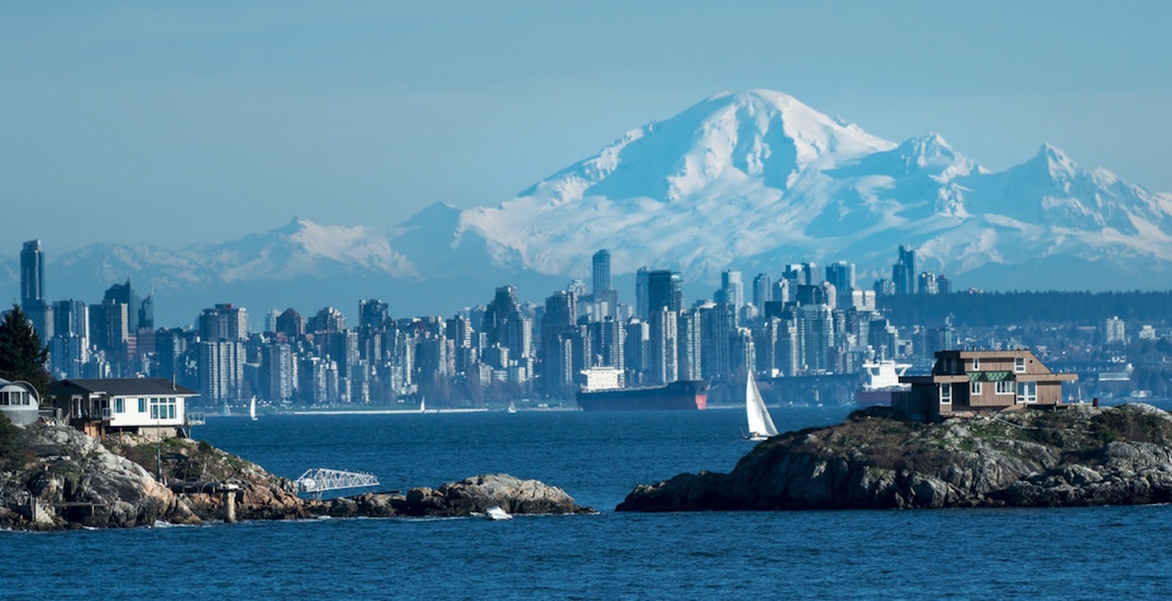
Using a telephoto lens, Mount Baker — located just south of BC’s border with Washington State — certainly appears much closer than it really is.
On a clear day, photographers have to try much harder to capture the ‘perfect shot’ of this volcano from West Vancouver or the Strait of Georgia on BC Ferries, as it certainly does not dominate the downtown Vancouver skyline in the same way that Mount Rainier backdrops Seattle
Mount Baker is still quite close to Metro Vancouver, about 110 km from the City of Vancouver, and even closer to the Fraser Valley — just 23 km from Abbotsford.

Map showing the location of Mount Baker and the distance from urban centres in the Lower Mainland of BC. (US Geological Survey)

Panorama of the Metro Vancouver region, with Mount Baker in the distance on the left and the Lions Gate Bridge and downtown Vancouver on the right. (Shutterstock)

View of Mount Baker from the Sumas Prairie in the Fraser Valley. (Shutterstock)
The close proximity of this 10,781-ft-tall stratovolcano – the youngest in the volcanic field at this part of the world – to one of the largest urban areas of Canada could be problematic. It is active, and this comes with the associated hazards.
However, an eruption of Mount Baker is unlikely to replicate the same destructive force as Mount St. Helens when it erupted in 1980, according to Professor Glyn Williams-Jones, who is a co-director of Simon Fraser University’s Centre for Natural Hazards Research.

Mount Baker photographed using a telephoto lens from a BC Ferries vessel in the Strait of Georgia. (Mark Donovan/Flickr)

Close-up view of Mount Baker and surrounding mountains. (Shutterstock)
He says pyroclastic flows, which is a particle and gas cloud with temperatures of between 200°C and 700°C and rapid speeds of up to 700 km/hr, are unlikely.
The larger concern with Mount Baker is lahars – the Indonesian term for destructive mudflows that have the consistency of wet concrete.
The potential for lahars is significant as Mount Baker has an estimated 1.8 cubic km of glacial ice – more than all of the other volcanoes on the Cascade Volcanic Arc, except Mount Rainier, combined.
Within hours of a volcanic event, lahars and flooding could occur in the Fraser Valley and parts of eastern Metro Vancouver.

Mount Baker during winter. (Shutterstock)
“It is plausible that if there was even a small eruption, a reactivation of the volcano system, a lot of that snow and ice atop the mountain will quickly melt and send mudflows down the valleys all along the flanks of the volcano,” Williams-Jones told Daily Hive Urbanized. “That could impact areas in the Lower Mainland. There are efforts being made to monitor that kind of thing.”
Slow-moving lava flows similar to what has been happening to Lellani Estates on the Big Island of Hawaii in 2018 are unlikely.
Instead, the other major potential impact from Mount Baker is ashfall, which could wreak havoc on flight operations at Vancouver International Airport. This was the case in 2010 when trans-Atlantic flights were significantly disrupted by ash being injected into the jet stream from the eruption of Eyafjallajökull in Iceland.

Mount Eyjafjallajokull erupting in Iceland on May 12 2010. The ash plume ejected into the jet stream caused disruptions to many international flights. (Shutterstock)
“Even a relatively small explosive eruption at Mount Baker with ash over a short distance in the air could lead to delays and cancellations for the airport,” he said.
“You’re dealing with pulverized rock, it should not be confused for a substance like cigarette ash or wood fire ash. It is a combination of the rock of the volcano itself, which is being fragmented and shattered into tiny particles. It’s basically magma, when liquid rock has frozen instantly into volcanic glass.”
Ash stalls plane engines, destroys electrical infrastructure, creates dangerous driving conditions, and severely damages lungs when inhaled. People with respiratory issues will likely have issues and could fill emergency rooms.

Sunrise with Mount Baker and the Lions Gate Bridge. (Shutterstock)
Another issue with ash is when it is mixed with water, it essentially becomes concrete and could threaten the structural integrity of weaker roofs.
“We see a lot of this in Indonesia and the Philippines where simple wood structure buildings would collapse. This is because when you mix that ash with rain, it’s like you just added three or four inches of cement to a roof. It just carpets everything,” Williams-Jones added.
Williams-Jones says the last time Vancouver saw ash scattered on outdoor surfaces was from the Mount St. Helens eruption of 1980. But Metro Vancouver’s general pattern of eastward and southward flowing winds could mitigate some of the ash plume emitted from Mount Baker.

Winds bring ash to Kagoshima, Japan during an eruption of the volcano Sakurajima on June 3, 2010. (Shutterstock)
Mount Baker’s previous eruption was in 1880, and Williams-Jones says it is difficult to predict when it will erupt again.
He points to the example of the April 2015 eruption of Calbuco in Chile when seismometers on the volcano provided just three hours warning prior to the eruption, which scattered ash across nearby cities.
“Sometimes these volcanoes catch you unaware,” he continued. “These systems are complex, and we try to forecast these events, but we need baseline monitoring. If we don’t have that, then we’re kind of blind.”

The male orca known as L95 Nigel surfaces off the shoreline of San Juan Island with Mount Baker in the background. (Shutterstock)
Every now and then, gases are seen rising from Mount Baker’s summit, but Williams-Jones says this is mostly steam from snow and ice sliding into the active crater.
Fortunately, Mount Baker is one of the most monitored and studied volcanoes in the United States due to its accessibility from urban areas and the relatively high level of funding for the US Geological Survey’s volcanology program following the Mount St. Helens eruption.
Two seismometers placed on the volcano by the US Geological Survey create a key early-warning system for an impending eruption, as a swarm of tremors within a short period of time could be a sign that magma is moving upwards.
ADVERTISEMENT
As a reminder of Mount Baker’s potency, the latest earthquake detected inside the volcano at the time of writing is a magnitude 1.1 tremor, striking at a shallow depth of 2.8 km, at 5:01 pm on Tuesday, November 16, 2021.
This is the Mount Baker ashfall forecast simulation by the US Geological Survey based on a major eruption during the weather conditions of the evening of Thursday, May 17, 2018. The location of the ashfall entirely depends on the weather of the day:

Mount Baker ashfall forecast if a major eruption were to happen on the evening of Thursday, May 17, 2018. This forecast takes into account meteorological conditions such as wind direction. (US Geological Survey)

Expected ash fall accumulation from a major Mount Baker eruption on the evening of Thursday, May 17, 2018. (US Geological Survey)
You might also like:
What is Sumas Lake? 100 years ago, Abbotsford had a 134 sq km lake (PHOTOS)
Here's how damaged Abbotsford's highways are after flooding (PHOTOS)
Aerial footage captures extent of flood devastation on Trans Canada Hwy in BC (PHOTOS)


