Friday, November 26, 2021


Pythagoras' revenge: Humans didn't invent mathematics, it's what the world is made of

Pythagoras’ revenge: humans didn’t invent mathematics, it’s what the world is made of
Credit: Geralt / Pixabay

Many people think that mathematics is a human invention. To this way of thinking, mathematics is like a language: it may describe real things in the world, but it doesn't "exist" outside the minds of the people who use it.

But the Pythagorean school of thought in ancient Greece held a different view. Its proponents believed reality is fundamentally mathematical.

More than 2,000 years later, philosophers and physicists are starting to take this idea seriously.

As I argue in a new paper, mathematics is an essential component of nature that gives structure to the physical world.

Honeybees and hexagons

Bees in hives produce hexagonal honeycomb. Why?

According to the "honeycomb conjecture" in mathematics, hexagons are the most efficient shape for tiling the plane. If you want to fully cover a surface using tiles of a uniform shape and size, while keeping the total length of the perimeter to a minimum, hexagons are the shape to use.

Charles Darwin reasoned that bees have evolved to use this shape because it produces the largest cells to store honey for the smallest input of energy to produce wax.

The honeycomb conjecture was first proposed in , but was only proved in 1999 by mathematician Thomas Hales.

Pythagoras’ revenge: humans didn’t invent mathematics, it’s what the world is made of
The hexagonal pattern of honeycomb is the most efficient way to cover a space in identical
 tiles. Credit: Sam Baron, Author provided
Cicadas and prime numbers

Here's another example. There are two subspecies of North American periodical cicadas that live most of their lives in the ground. Then, every 13 or 17 years (depending on the subspecies), the cicadas emerge in great swarms for a period of around two weeks.

Why is it 13 and 17 years? Why not 12 and 14? Or 16 and 18?

One explanation appeals to the fact that 13 and 17 are prime numbers.

Imagine the cicadas have a range of predators that also spend most of their lives in the ground. The cicadas need to come out of the ground when their predators are lying dormant.

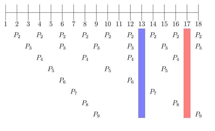
Suppose there are predators with life cycles of two, three, four, five, six, seven, eight and nine years. What is the best way to avoid them all?

Well, compare a 13-year life cycle and a 12-year life cycle. When a cicada with a 12-year life cycle comes out of the ground, the 2-year, 3-year and 4-year predators will also be out of the ground, because two, three and four all divide evenly into 12.

When a cicada with a 13-year life cycle comes out of the ground, none of its predators will be out of the ground, because none of two, three, four, five, six, seven, eight or nine years divides evenly into 13. The same is true for 17.

It seems these cicadas have evolved to exploit basic facts about numbers.

Pythagoras’ revenge: humans didn’t invent mathematics, it’s what the world is made of
Some cicadas have evolved to emerge from the ground at intervals of a prime number of
 years, possibly to avoid predators with life cycles of different lengths. 
Credit: Michael Kropiewnicki / Pixels

Creation or discovery?

Once we start looking, it is easy to find other examples. From the shape of soap films, to gear design in engines, to the location and size of the gaps in the rings of Saturn, mathematics is everywhere.

If mathematics explains so many things we see around us, then it is unlikely that mathematics is something we've created. The alternative is that mathematical facts are discovered: not just by humans, but by insects, soap bubbles, combustion engines and planets.

What did Plato think?

But if we are discovering something, what is it?

The ancient Greek philosopher Plato had an answer. He thought mathematics describes objects that really exist.

For Plato, these objects included numbers and geometric shapes. Today, we might add more complicated mathematical objects such as groups, categories, functions, fields and rings to the list.

Plato also maintained that mathematical objects exist outside of space and time. But such a view only deepens the mystery of how mathematics explains anything.

Explanation involves showing how one thing in the world depends on another. If mathematical objects exist in a realm apart from the world we live in, they don't seem capable of relating to anything physical.
Pythagoras’ revenge: humans didn’t invent mathematics, it’s what the world is made of
P1–P9 represent cycling predators. The number-line represents years. The highlighted 
gaps show how 13 and 17-year cicadas manage to avoid their predators. 
Credit: Sam Baron, Author provided

Enter Pythagoreanism

The ancient Pythagoreans agreed with Plato that mathematics describes a world of objects. But, unlike Plato, they didn't think mathematical objects exist beyond space and time.

Instead, they believed physical reality is made of mathematical objects in the same way matter is made of atoms.

If reality is made of mathematical objects, it's easy to see how mathematics might play a role in explaining the world around us.

In the past decade, two physicists have mounted significant defenses of the Pythagorean position: Swedish-US cosmologist Max Tegmark and Australian physicist-philosopher Jane McDonnell.

Tegmark argues reality just is one big mathematical object. If that seems weird, think about the idea that reality is a simulation. A simulation is a computer program, which is a kind of mathematical .

McDonnell's view is more radical. She thinks reality is made of  and minds. Mathematics is how the Universe, which is conscious, comes to know itself.

I defend a different view: the world has two parts, mathematics and matter. Mathematics gives matter its form, and matter gives mathematics its substance.

Mathematical objects provide a structural framework for the physical world.

Pythagoras’ revenge: humans didn’t invent mathematics, it’s what the world is made of
Pythagorean pie: the world is made of mathematics plus matter. 
Credit: Sam Baron, Author provided

The future of mathematics

It makes sense that Pythagoreanism is being rediscovered in physics.

In the past century physics has become more and more mathematical, turning to seemingly abstract fields of inquiry such as group theory and differential geometry in an effort to explain the physical world.

As the boundary between physics and  blurs, it becomes harder to say which parts of the world are physical and which are mathematical.

But it is strange that Pythagoreanism has been neglected by philosophers for so long.

I believe that is about to change. The time has arrived for a Pythagorean revolution, one that promises to radically alter our understanding of reality.
Studying abstract mathematical equations using tangible surfaces
Provided by The Conversation 

Were the ancient Maya an agricultural cautionary tale? Maybe not, new study suggests

Were the ancient Maya an agricultural cautionary tale? Maybe not, new study suggests
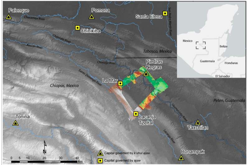
The research team surveyed a small area in the Western Maya Lowlands situated at
 today's border between Mexico and Guatemala, shown in context here. 
Credit: Andrew Scherer/Brown University

Many believe climate change and environmental degradation caused the Maya civilization to fall—but a new survey shows that some Maya kingdoms had sustainable agricultural practices and high food yields for centuries.

For years, experts in climate science and ecology have held up the agricultural practices of the ancient Maya as prime examples of what not to do.

"There's a narrative that depicts the Maya as people who engaged in unchecked agricultural development," said Andrew Scherer, an associate professor of anthropology at Brown University. "The narrative goes: The population grew too large, the agriculture scaled up, and then everything fell apart."

But a new study, authored by Scherer, students at Brown and scholars at other institutions, suggests that that narrative doesn't tell the full story.

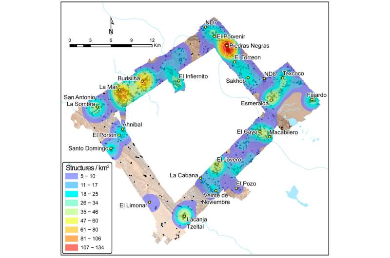
Using drones and lidar, a remote sensing technology, a team led by Scherer and Charles Golden of Brandeis University surveyed a small area in the Western Maya Lowlands situated at today's border between Mexico and Guatemala. Scherer's lidar survey—and, later, boots-on-the-ground surveying—revealed extensive systems of sophisticated irrigation and terracing in and outside the region's towns, but no huge population booms to match. The findings demonstrate that between 350 and 900 A.D., some Maya kingdoms were living comfortably, with sustainable agricultural systems and no demonstrated food insecurity.

"It's exciting to talk about the really large populations that the Maya maintained in some places; to survive for so long with such density was a testament to their technological accomplishments," Scherer said. "But it's important to understand that that narrative doesn't translate across the whole of the Maya region. People weren't always living cheek to jowl. Some areas that had potential for agricultural development were never even occupied."

The research group's findings were published in the journal Remote Sensing.

When Scherer's team embarked on the lidar survey, they weren't necessarily attempting to debunk long-held assumptions about Maya agricultural practices. Rather, their primary motivation was to learn more about the infrastructure of a relatively understudied region. While some parts of the western Maya area are well studied, such as the well-known site of Palenque, others are less understood, owing to the dense tropical canopy that has long hidden ancient communities from view. It wasn't until 2019, in fact, that Scherer and colleagues uncovered the kingdom of Sak T'zi," which archeologists had been trying to find for decades.

Were the ancient Maya an agricultural cautionary tale? Maybe not, new study suggests
Lidar scans of the research area revealed the relative density of structures in Piedras 
Negras, La Mar and Lacanjá Tzeltal, providing hints at these cities' respective populations
 and food needs. Credit: Brown University

The team chose to survey a rectangle of land connecting three Maya kingdoms: Piedras Negras, La Mar and Sak Tz'i," whose political capital was centered on the archeological site of Lacanjá Tzeltal. Despite being roughly 15 miles away from one another as the crow flies, these three urban centers had very different population sizes and governing power, Scherer said.

"Today, the world has hundreds of different nation-states, but they're not really each other's equals in terms of the leverage they have in the geopolitical landscape," Scherer said. "This is what we see in the Maya empire as well."

Scherer explained that all three kingdoms were governed by an ajaw, or a lord—positioning them as equals, in theory. But Piedras Negras, the largest kingdom, was led by a k'uhul ajaw, a "holy lord," a special honorific not claimed by the lords of La Mar and Sak Tz'i." La Mar and Sak Tz'i' weren't exactly equal peers, either: While La Mar was much more populous than the Sak T'zi' capital Lacanjá Tzeltal, the latter was more independent, often switching alliances and never appearing to be subordinate to other kingdoms, suggesting it had greater political autonomy.

The lidar survey showed that despite their differences, these three kingdoms boasted one major similarity: Agriculture that yielded a food surplus.

"What we found in the lidar survey points to strategic thinking on the Maya's part in this area," Scherer said. "We saw evidence of long-term agricultural infrastructure in an area with relatively low population density—suggesting that they didn't create some  late in the game as a last-ditch attempt to increase yields, but rather that they thought a few steps ahead."

In all three kingdoms, the lidar revealed signs of what the researchers call "agricultural intensification"—the modification of land to increase the volume and predictability of crop yields. Agricultural intensification methods in these Maya kingdoms, where the primary crop was maize, included building terraces and creating water management systems with dams and channeled fields. Penetrating through the often-dense jungle, the lidar showed evidence of extensive terracing and expansive irrigation channels across the region, suggesting that these kingdoms were not only prepared for population growth but also likely saw food surpluses every year.

"It suggests that by the late Classic Period, around 600 to 800 A.D., the area's farmers were producing more food than they were consuming," Scherer said. "It's likely that much of the surplus food was sold at urban marketplaces, both as produce and as part of prepared foods like tamales and gruel, and used to pay tribute, a tax of sorts, to local lords."

Scherer said he hopes the study provides scholars with a more nuanced view of the ancient Maya—and perhaps even offers inspiration for members of the modern-day agricultural sector who are looking for sustainable ways to grow food for an ever-growing global population. Today, he said, significant parts of the region are being cleared for cattle ranching and palm oil plantations. But in areas where people still raise corn and other crops, they report that they have three harvests a year—and it's likely that those high yields may be due in part to the channeling and other modifications that the ancient Maya made to the landscape.

"In conversations about contemporary climate or ecological crises, the Maya are often brought up as a cautionary tale: "They screwed up; we don't want to repeat their mistakes,'" Scherer said. "But maybe the Maya were more forward-thinking than we give them credit for. Our survey shows there's a good argument to be made that their agricultural practices were very much sustainable."In Guatemala, archaeologists uncover hidden neighborhood in ancient Maya city

More information: Charles Golden et al, Airborne Lidar Survey, Density-Based Clustering, and Ancient Maya Settlement in the Upper Usumacinta River Region of Mexico and Guatemala, Remote Sensing (2021). DOI: 10.3390/rs13204109

Provided by Brown University 

Skull found on Caribbean island shows evidence of leprosy

Skull found on Caribbean island shows evidence of leprosy
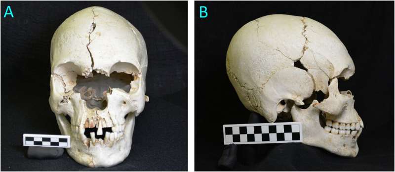
Petite Mustique 1. A, norma frontalis. B, right norma lateralis (All photos by GCN). 
Credit: DOI: 10.1016/j.ijpp.2021.10.004

A skull unearthed on an uninhabited Caribbean island is a rare find: It's one of just a few examples of leprosy identified on a skeleton in the western hemisphere.

And it's the only one that's been directly dated using radiocarbon, by analyzing a fragment of the skull itself rather than estimating an age using nearby artifacts or materials. The bones are from the late 18th or early 19th century, reports a team led by UO archaeologist Scott Fitzpatrick.

Fitzpatrick's team, which also included lead author and skeletal biologist Greg Nelson and former UO honors student Taylor Dodrill, detailed their findings in a paper published online Nov. 13 in the International Journal of Paleopathology.

The specimen was found on Petite Mustique, a rugged uninhabited island. Historical records suggest that the island might have been the site of a leprosarium in the early 1800s, when people with  could be isolated to prevent spread of .

"There are a number of pretty well-known cases in the Caribbean and Pacific where smaller  were used as places to segregate people with leprosy, such as Molokai in Hawaii," said Fitzpatrick, who is also the associate director for research at the Museum of Natural and Cultural History.

But while leprosy has been documented in the Caribbean via written evidence beginning around the mid-17th century, those reports have been incomplete. Archaeologists have found scant skeletal evidence of the disease that could help trace its pattern of spread. This new find adds to that picture.

Leprosy causes dramatic disfigurement of the hands, feet and face, and those changes show up in bones. Nelson determined that the person had leprosy based on the pattern of skeletal deformation in the nose and upper jaw of the skull.

The disease spreads through prolonged close contact with someone who is sick, but "the fact that leprosy can also lead to noticeable disfigurement of the hands, feet and particularly the face made it a very scary disease and likely precipitated moves to isolate people with leprosy," Nelson said.Leprosy confirmed in wild chimpanzees

More information: Greg C. Nelson et al, A probable case of leprosy from colonial period St. Vincent and the Grenadines, Southeastern Caribbean, International Journal of Paleopathology (2021). DOI: 10.1016/j.ijpp.2021.10.004

Provided by University of Oregon 

Genetic changes in Bronze Age Southern Iberia

Genetic changes in Bronze Age Southern Iberia
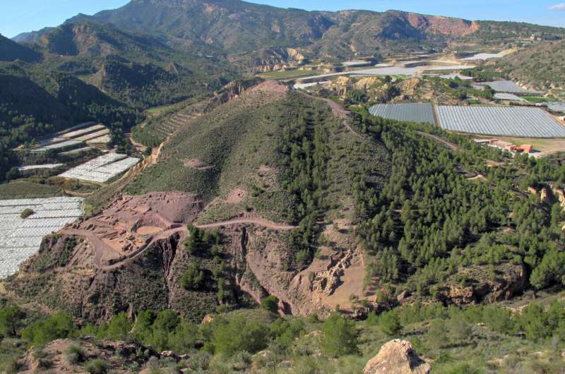
The fortified settlement of La Bastida (Totana, Murcia). This is one of the largest and best 
excavated settlements of El Argar. Credit: ASOME-UAB

The third millennium BCE is a highly dynamic period in the prehistory of Europe and western Asia, characterized by large-scale social and political changes. In the Iberian Peninsula, the Copper Age was in full swing in around 2500 years BCE with substantial demographic growth, attested by a large diversity of settlements and fortifications, monumental funerary structures, as well as ditched mega-sites larger than 100 hectares. For reasons that are still unclear, the latter half of the millennium experienced depopulation and the abandonment of the mega-sites, fortified settlements and necropolis.

In southeastern Iberia, one of the most outstanding archaeological entities of the European Bronze Age emerged around 2200 BCE. Known as the El Argar culture, one of the first state-level societies on the European continent, it was characterized by large, central hilltop settlements, distinct pottery, specialized weapons and bronze, silver and gold artifacts, alongside an intramural burial rite.

A new study led by researchers from the Universitat Autònoma de Barcelona and the Max Planck Institutes for the Science of Human History (Jena) and Evolutionary Anthropology (Leipzig) and published in Science Advances, explores the relation between dynamic shifts at population scale and the major social and political changes of the third and second millennia BCE by analyzing the genomes of 136 ancient Iberians, ranging from 3000 to 1500 BCE.

Genetic turnover and melting pot

Including published genomes from Iberia, the new study encompasses data from nearly 300 ancient individuals and focuses specifically on the Copper to Bronze Age transition around 2200 BCE.

"While we knew that the so-called 'steppe'-related ancestry, which had spread across Europe during the third millennium BCE, eventually reached the northern Iberian Peninsula around 2400 BCE, we were surprised to see that all prehistoric individuals from the El Argar period carried a portion of this ancestry, while the Chalcolithic individuals did not," says Max Planck researcher Wolfgang Haak, senior author and principal investigator of the study.

Genetic changes in Bronze Age Southern Iberia
Female (right) and male (left) individuals of burial 38 of the settlement of La Almoloya
 (Pliego, Murcia). This is one of the richest burials found in an El Argar settlement. 
Credit: ©ASOME-UAB

The genomic data reveals some of the processes underlying this genetic shift. While the bulk of the genome shows that Bronze Age individuals are a mix of local Iberian Chalcolithic ancestry and a smaller part of incoming ancestry from the European mainland, the paternally inherited Y chromosome lineages show a complete turnover, linked to the movement of steppe-related ancestry that is also visible in other parts of Europe.

The rich new data from the El Argar sites also show that these two components do not fully account for the genetic make-up of the early Bronze Age societies. "The causes of this disappearance of the previous diversity of the Y chromosome are still very difficult to explain," says Cristina Rihuete Herrada, UAB researcher and co-author of the study.

"We also found signals of ancestry that we traced to the central and eastern Mediterranean and western Asia. We cannot say exactly whether these influences arrived at the same time as the steppe-related ancestry, but it shows that it formed an integrative part of the rising El Argar societies, attesting to continued contacts to these regions," adds Vanessa Villalba-Mouco, postdoctoral researcher and lead author of the study.

UAB researchers already pointed to possible Mediterranean connections when they discovered in 2013 the monumental fortification of the Argaric settlement of La Bastida, in Murcia, to explain the originality of some architectural elements. "The genetic study argues in favor of this hypothesis: the data show that this unknown Mediterranean connection would have been sustained over time until the end of the period of El Argar, around 1500 BCE," says Rafael Micó, UAB researcher and co-author of the study.

Social implications

"Whether the genetic shift was brought about by migrating groups from North and Central Iberia or by climatic deteriorations that affected the eastern Mediterranean around 2200 BCE is the million-dollar question," says co-principal investigator and senior author Prof Roberto Risch from the Universitat Autònoma de Barcelona. "It would be foolish to think that it can all be explained by a simple, one-factor model. While the temporal coincidence is striking, it is likely that many factors played a role."

Genetic changes in Bronze Age Southern Iberia
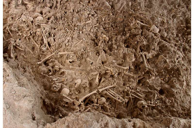
Copper Age collective burial of Camino del Molino (Caravaca de la Cruz, Murcia), where a
 total of ~1300 individuals were buried between 2900-2300 BCE. The image shows the
 last burial layer, dated between 2500-2300 BCE, from which six individuals have been 
analysed. Credit: Universidad de Murcia. Fotografía de Francisco Ramos

One of these factors could be pandemics, such as an early form of the Plague, which has been attested to in other regions of Europe around that time. While not found directly among the tested individuals in southern Iberia, it could be a cause or driver for the movement or disappearance of other groups in the region.

"In any case, we can now conclude that the population movement starting in the eastern European steppe zones around 3000 BCE was not a single migratory event, but required over four centuries to reach the Iberian Peninsula and another 200 years to appear in present-day Murcia and Alicante," adds Risch.

The archaeological record of the El Argar group shows a clear break with previous Chalcolithic traditions. Burial rites, for example, changed from communal to single and double burials within the building complexes. Elite burials also indicate the formation of strong social hierarchies. Testing for biological relatedness, the researchers found that males are on average more closely related to other people at the site, indicating that the group was likely patrilineally structured. Such a social organization could explain the stark reduction of the Y-lineage diversity.

"We observe similar patterns of social organization and increasing stratification also in other parts of Early Bronze Age Europe, in fact broadly around the same time and with similar characteristics of early state-like formations. This suggests a structured restart or resetting following some form of crisis or unstable, highly dynamic times," summarizes Haak.

In the research have participated, among others, these institutions: Adelaide University, Danube Private University, Basel University, Fundación Vasca para la Ciencia, Universidad de Valencia, Cape Town University, Universidad de Alicante, Museo Arqueológico de Alicante, Museo Arqueológico Municipal de Lorca, Universidad de Murcia, Harvard Medical School, Harvard University, Howard Hughes Medical Institute y Universidad de Sevilla.

Central European prehistory was highly dynamic

More information: Vanessa Villalba-Mouco et al, Genomic transformation and social organization during the Copper Age-Bronze Age transition in southern Iberia, Science Advances (2021). DOI: 10.1126/sciadv.abi7038. www.science.org/doi/10.1126/sciadv.abi7038

Journal information: Science Advances 

Provided by Autonomous University of Barcelona 

The world's oldest mercury poisoning revealed in Copper Age Iberia

The world's oldest mercury poisoning revealed in Copper Age Iberia
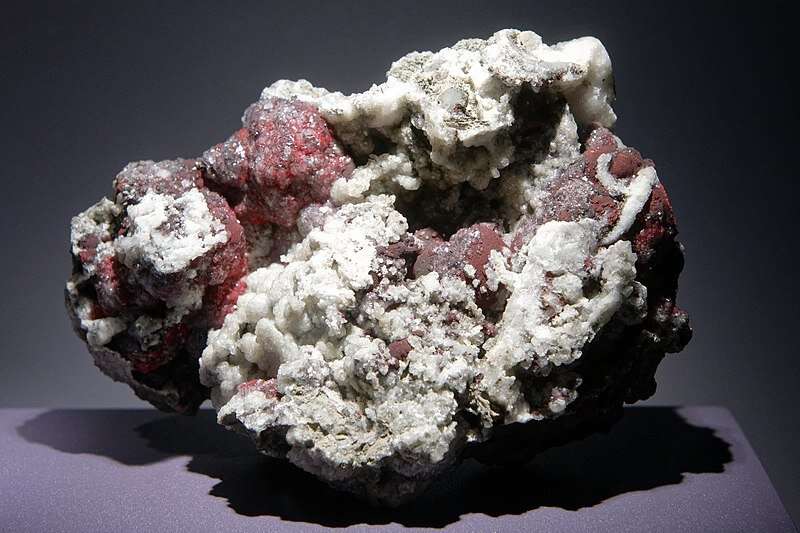
Cinnabar from Mine Siele, Tuscany, Italy. Gallery of Mineralogy and Geology of the 
French National Museum of Natural History in Paris. Credit: Marie-Lan Taÿ Pamart, 
CC-BY 4.0

The World Health Organization (WHO) states that exposure to mercury, a natural element that can be present in the air, water and soil, can cause serious health problems, even in small amounts. Mercury contamination or poisoning can have serious toxic effects on humans, affecting the nervous, digestive, and immune systems, as well as the lungs, kidneys, skin, and eyes. The WHO currently considers mercury to be one of the top ten substances of greatest public health concern.

A recent paper published in the International Journal of Osteoarchaeology and in which researchers from the University of Seville participate, explores the complex relationship between humans and  over time. In this article, titled "The use and abuse of cinnabar in Late Neolithic and Copper Age Iberia," a team of 14 specialists in biology, chemistry,  and archaeology have presented the results of the largest study ever carried out on the presence of mercury in human bone, with a sample of a total of 370 individuals from 50 tombs located in 23  in Spain and Portugal dating from Neolithic, Copper Age, Bronze Age and antiquity, thus encompassing 5,000 years of human history.

The results reveal that the highest levels of mercury exposure occurred at the beginning of the Copper Age, between 2900 and 2600 BC. In this period, the exploitation and use of cinnabar increased considerably for social and cultural reasons. Cinnabar (HgS) is a mercury sulfide mineral that, when pulverized, turns into a powder of a striking and brilliant red color. Historically, this substance has been used to produce pigments in paint, being famous already in antiquity ("Pompeian red") or in modern art (known as "vermilion"). It so happens that the largest cinnabar mine in the world, declared a World Heritage Site by UNESCO, is located in Almadén, in central Spain).

The exploitation of the Almadén cinnabar began in the Neolithic, 7,000 years ago. By the beginning of the Copper Age, around 5000 years ago, cinnabar became a product of great social value, with a character that was both sacred, esoteric and sumptuous. In tombs from this period discovered in southern Portugal and Andalusia, cinnabar powder (often turned into a pigment) was used to paint megalithic chambers, decorate figurines or stelae, and to spread it over the dead. As a result, many people must have accidentally inhaled or consumed it, leading to unsuspected accumulations of mercury in their bodies. Levels of up to 400 parts per million (ppm) have been recorded in the bones of some of these individuals. Taking into account that the WHO currently considers that the normal level of mercury in hair should not be higher than 1 or 2 ppm, the data obtained reveal a high level of intoxication that must have severely affected the health of many of those people. In fact, the levels detected in some subjects are so high that the study authors do not rule out that cinnabar powder was deliberately consumed, by inhalation of vapors, or even ingestion, for the ritual, symbolic and esoteric value that was attributed to it.

The results of this study provide scientific evidence of great value to expand future research on the complex relationship of human beings with mercury, one of the most peculiar mineral substances on our planet, and to learn about its uses and their consequences for human health.Fish consumption still safe despite initial fears over mercury levels

More information: Steven D. Emslie et al, The Use and Abuse of Cinnabar in Late Neolithic and Copper Age Iberia, International Journal of Osteoarchaeology (2021). DOI: 10.1002/oa.3056

Provided by University of Seville 

Easternmost Roman aqueduct discovered in Armenia

Easternmost Roman aqueduct discovered in Armenia
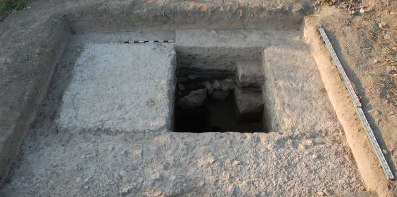
The excavation trench shows a pillar of the unfinished aqueduct. Credit: Artaxata project

Archaeologists from the University of Münster and the National Academy of Sciences of the Republic of Armenia have discovered remains of a Roman arched aqueduct during excavation work on the Hellenistic royal city of Artashat-Artaxata in ancient Armenia. It is the easternmost arched aqueduct in the Roman Empire. Excavation work took place back in 2019, and an evaluation of the find has now been published in the Archäologischer Anzeiger journal.

"The monumental foundations are evidence of an unfinished aqueduct bridge built by the Roman army between 114 and 117 CE," explains author Prof. Achim Lichtenberger from the Institute of Classical Archaeology and Christian Archaeology at the University of Münster. "At that time, Artaxata was destined to become the capital of a Roman province in Armenia." It was during this time that the Roman Empire reached its greatest extent—if only for a short while—because it was under Trajan, who was Emperor of Rome from 98 to 117 CE—that the Romans attempted to incorporate the province of Armenia into the Roman Empire. "The planned, and partially completed, construction of the aqueduct in Artaxata shows just how much effort was made, in a very short space of time, to integrate the infrastructure of the capital of the province into the Empire," says co-author Torben Schreiber from the Institute of Classical Archaeology and Christian Archaeology at the University of Münster. "The aqueduct remained unfinished because after Trajan's death, in 117 CE, his successor Hadrian relinquished the province of Armenia before the aqueduct was completed." The archaeologists therefore see their find as furnishing evidence for the failure of Roman imperialism in Armenia.

Easternmost Roman aqueduct discovered in Armenia
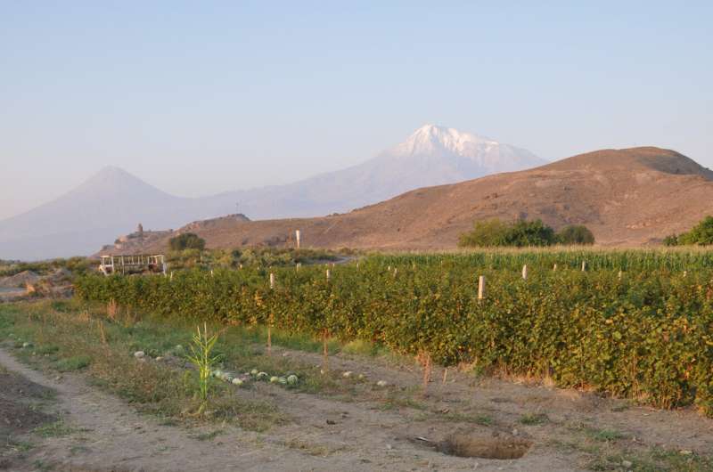
In the background of the excavation area is the hillock in Artaxata on which is located the 
Khor Virap monastery, with Mount Ararat behind it. Credit: Artaxata project

Methods

In their excavation campaign, the team used a multidisciplinary combination of methods from the fields of archaeology, geophysics, geochemistry and archaeoinformatics. The area of the Hellenistic metropolis of Artaxata in the Ararat Plain was first examined geomagnetically. At this stage of their work, the experts surveyed and charted any anomalies. The geomagnetic image showed a conspicuous dotted line, which they analyzed with so-called sondages. The results were documented by the archaeologists three-dimensionally. Additional drillings provided evidence of further unfinished or destroyed pillars of the aqueduct. "We used satellite pictures and infrared images from a drone to visualize the course of the aqueduct's pillars," says co-author Dr. Mkrtich Zardaryan from the Institute of Archaeology and Ethnography at the National Academy of Sciences of the Republic of Armenia. "We reconstructed the planned course of the aqueduct by means of a computer-assisted path analysis between the possible sources of the water and its destination." A scientific analysis of the lime mortar used showed that it was a typical Roman recipe. An analysis of soil samples dated the construction of the  to between 60 and 460 CE, and in the opinion of the researchers this makes the reign of Emperor Trajan the most likely dating for it.

Project: "Artaxata in Armenia—Fieldwork in a Hellenistic Metropolis in the Ararat Plain"

Since 2018 a team of German and Armenian scientists—headed by Achim Lichtenberger (Münster University), Mkrtich Zardaryan (Armenian Academy of Sciences) and Torben Schreiber (Münster University) – have been carrying out research into the Hellenistic metropolis of Artaxata in the Ararat Plain in Armenia. Their aim is to examine both a newly established Hellenistic royal city and the many-faceted cultural imprint between Central Asia, Iran and the Mediterranean region.The Aqueduct of Constantinople: Managing the longest water channel of the ancient world

More information: A. Lichtenberger et al, An Unfinished Roman Aqueduct at Artaxata in Armenia, Archäologischer Anzeiger 2021. doi.org/10.34780/8f82-fyw2

Provided by University of Münster 

Australia's coal country looks to a less sooty future

Australia's conservative government has boasted it will sell coal for as long as anyone is buying
Australia's conservative government has boasted it will sell coal for as long as anyone is
 buying.

Australia's conservative leaders have defied calls for urgent climate action, boasting they will sell coal for as long as anyone is buying. But in the country's carbon heartland, locals are already preparing for life beyond fossil fuels.

Two-hundred-and-thirty years ago, among the verdant outcrops that flank the southeastern coastal town of Newcastle, a band of escaped convicts made the first recorded discovery of  on the Australian continent.

It would begin Australia's long love affair with the sooty fuel that now nets the country tens of billions of dollars a year and has made Newcastle the world's largest coal-exporting port.

Nathan Clements was born and raised in the nearby town of Singleton, which he described as "very much the heartland of coal mining here".

"I don't want to say coal is everything, but it's a lot," he said.

"My older brother worked in a coal mine, my dad worked in a mine and still does to this day. When it was my turn, it was the norm to walk into that industry," said the 26-year-old, who for the last seven years has worked as an electrical fitter fixing mine equipment.

Around Singleton and the broader Hunter region, evidence of the vast scale of the coal industry is obvious.

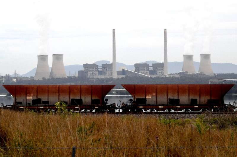
Coal trains rumble through the countryside, each engine dragging a writhing column of rusty wagons from far into the distance.

In Australia's coal heartland, however, locals are already preparing for life beyond fossil fuels
In Australia's coal heartland, however, locals are already preparing for life beyond fossil fuels.

From the air, open cast mines pock the bush with jet-black scars. Off the coast, an armada of vessels waits, ready to load up and return to China, India, Japan or South Korea with mountains of millennia-old rock.

And Australia's government would like to keep it that way.

When dozens of countries, meeting at COP26 talks in Glasgow, recently agreed to phase out coal, Australia baulked.

"We are not closing coal mines and we are not closing coal-fired power stations," said resource minister Keith Pitt, using the opportunity to boast about the quality of Australian coal and 300,000 Australian jobs linked to the sector.

'A change in attitudes'

But unlike the government, workers in Singleton and towns across the Hunter are gradually coming to terms with King Coal's demise.

"I still need to work. I still need a job," said Clements, but "it is inevitable. There is an inevitability to it."

Coal nets Australia billions of dollars a year
Coal nets Australia billions of dollars a year.

For him, there was a slow realisation that he might not be able to follow the career path of his father, who will retire in his coal job next year when Muswellbrook—Australia's oldest open cut coal mine—closes after almost 115 years of operation.

Clements said discussing the industry's future has become markedly less taboo and scepticism more mainstream with catastrophic events of the last few years.

"For a lot of people, I noticed a change in attitudes around the 2019-2020 bushfires," he said, referring to the climate-worsened disaster that tore through much of southeastern Australia.

And despite the government's bravado, the market is voting with its feet.

The very largest mining firms, such as Australia's own BHP and Rio Tinto, are already sprinting for the exits, rapidly offloading coal assets to smaller risk-embracing outfits.

Official figures show the number of people directly employed in the coal industry is more like 44,600—less than half the number of Australians employed by McDonald's.

Some in the coal sector are fearful that well-paying jobs are going to quickly become a thing of the past.

Newcastle in Australia is the world's largest coal-exporting port
Newcastle in Australia is the world's largest coal-exporting port.

No silver bullet

But others are optimistic that their region will succeed despite Canberra's digging in on a seemingly dying industry.

"There's so much innovation going on," said Sam Mella of Beyond Zero Emissions, a think tank working with local industry on diversification.

She pointed to the infrastructure around coal—the port, the rail network, transmission lines as well as universities and research institutes—as a valuable asset for the region.

"We have this fantastic legacy to build on," she said. "I think the Hunter is going to lead the way in the post-carbon economy."

So far, there is no silver bullet—no one technology or project that will save the entire region or replace coal.

But there is hope that out of the plethora of projects, from water filtration technology to megawatt-scale batteries to designing and manufacturing hyper-efficient wind turbines, that something will emerge.

So far, there is no silver bullet—no one technology or project that will save the entire region or replace coal
So far, there is no silver bullet—no one technology or project that will save the entire region
 or replace coal.

The question is whether the transition can come quickly enough for workers like Clements.

"My concern is that when the market finally says 'nah, we're not interested anymore' that we don't have a plan, and a lot of people lose their jobs."

But "I think there is still a chance for the region, I don't think it's a one-way ticket," he said. "There is definitely still a bit of life there."Australia vows to keep mining coal despite climate warning

© 2021 AFP

Syria reservoir dries up for first time

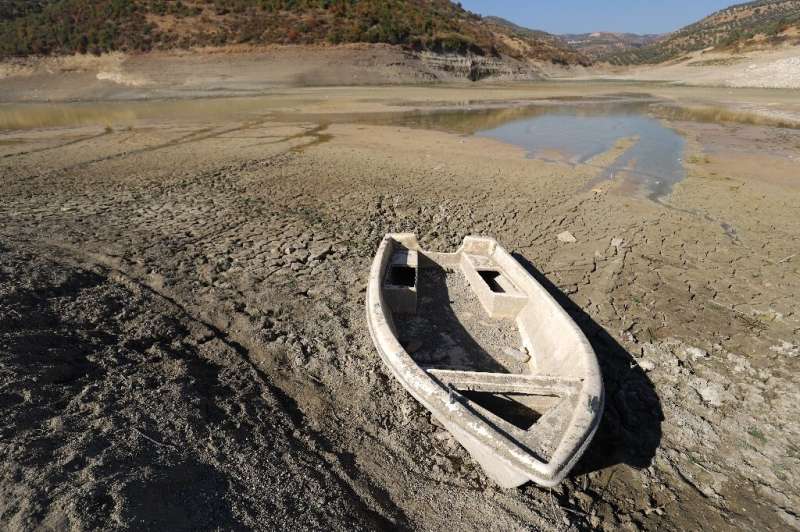
A rowing boat lies grounded on the exposed lake bed of Syria's Duwaysat Dam reservoir after it dried up completely for the first
A rowing boat lies grounded on the exposed lake bed of Syria's Duwaysat Dam reservoir 
after it dried up completely for the first time in its 27-year history.

Low rainfall, structural damage and extraction by struggling farmers have emptied a key reservoir in northwestern Syria, leaving it completely dry for the first time, farmers and officials told AFP.

With man-made climate change increasing the frequency of drought and wildfires worldwide, Syria is experiencing one of its driest and hottest years on record after historically low rainfall last winter.

The reservoir formed by Al-Duwaysat Dam in Idlib province, a key irrigation source for thousands of farmers, has completely dried up for the first time in its 27-year history.

The exposed lake bed is parched to a crisp in many places, a sinister expanse littered with stranded rowing boats, animal skulls and dead trees.

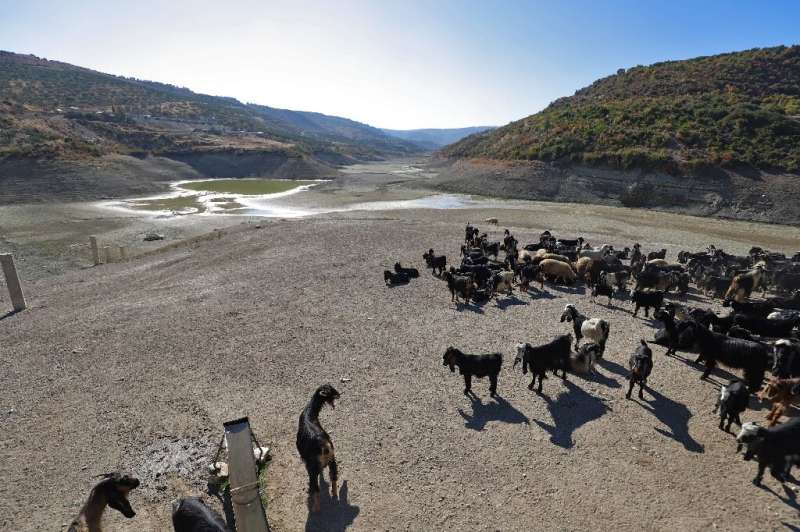
A few shallow pools remain, around which small flocks of sheep graze on new shoots.

According to the World Bank, the reservoir has a capacity of a 3.6 million cubic metres (38.8 million square feet) and is mainly used for irrigation and water supply.

"Because of drought and low rainfall, we can now walk on the floor of the reservoir," its managing engineer Maher al-Hussein said, recalling that it was full to capacity just two years ago.

Low rainfall last winter left the reservoir half-full and all the water was used for irrigation by farmers trying to save their crops, Hussein said.

A shepherd waters his flock from the small pools that are that are all that is left of the reservoir following successive years
A shepherd waters his flock from the small pools that are that are all that is left of the 
reservoir following successive years of low rainfall.

Damage to the main pipeline that feeds water from the reservoir to irrigation networks has led to significant leakages, further reducing the volume that reaches the fields, he added.

"It is the first time the reservoir has dried out since it was built in 1994," Hussein said.

He said around 800 families depended on the reservoir to irrigate 150 hectares (370 acres) of farmland.

"For 10 years we have come to this reservoir," said cattle farmer Abu Joumaa. "If God does not send us good rainfall that could fill the reservoir this year... people won't be able to grow crops they rely on to make a living."

Colorado basin drought sparks water limits at huge US reservoir

© 2021 AFP