Showing posts with label Volcano. Show all posts

Tuesday, October 02, 2007

Red Sea Volcano

Three weeks after the tectonic plates moved in Indonesia they had an impact in Africa.

Jabal al-Tair, meaning bird mountain, is one of several volcanoes at the southern end of the Red Sea between Yemen and Sudan.

The island, two miles wide, has no civilian population, only military installations used for Yemeni naval control. It is not clear how many military personnel were there during the eruption.

Jabal al-Tair's last eruption was in 1883, according to the Washington-based Smithsonian Institute's global volcano programme.

There had been considerable seismic activity around the island ahead of yesterday's eruption, the Yemeni defence ministry said on its website, including an earthquake of magnitude 7.3 on Friday.


Canadian National Defence image shows lava flows and clouds of smoke and ash


The image “http://www.gulf-daily-news.com/source/xxx/196/images/Wpic1.jpg” cannot be displayed, because it contains errors.

http://afp.google.com/media/ALeqM5haOS3Py_m64Cl8fBrsxHu5AI7CiA?size=m


http://afp.google.com/media/ALeqM5gNMmaAHWORHUH_86PAWM7IBGmCSg?size=m

This gives new meaning to Toronto the Good.

A Canadian navy ship rescued a Yemeni soldier Monday following a volcanic eruption on a small island in the Red Sea.

HMCS Toronto was part of a NATO fleet in the area that was called upon by the Yemeni government to help rescue its soldiers after the eruption began Sunday evening.

HMCS Toronto is seen during operations, part of Canada's contribution to Standing NATO Maritime Group 1, an international naval rapid deployment fleet. (Master Cpl. Kevin Paul / Canadian Forces Combat Camera)

Canadian Navy divers in small boats were seen searching the waters surrounding the island late Monday.

A survivor described to Deutsche Presse-Agentur dpa the first moments of the disaster.

"It was horrible. It started with shocks like quakes, and then we heard huge blasts with lava and rocks spewing out and dropping on us," Ahmad Abdullah al-Jalal, who was rescued by the Canadian frigate HMCS Toronto, told dpa aboard the vessel.

Al-Jalal said that he and six fellow soldiers decided to flee the island by trying to swim through "boiling water" surrounding the tiny island.

"Some of them cried 'the sea,' advising that we should jump to the water before it got hotter," he said.

"I saw four of my colleagues dying in the boiling water just behind me," al-Jalal said as he was being comforted by Yemeni Coast Guard officers who boarded the Canadian ship to receive him and the remains of the two soldiers recovered by the Canadian sailors.


Find blog posts, photos, events and more off-site about:
,
, , , ,
, , , , , , ,
, , , , , ,
, , , , , , , , , , , , , ,
, , , , , , , , , , , , , , , , , ,

Saturday, September 15, 2007

Coral


Two interesting stories appeared this week on coral. The fact they are endangered and that they have been discovered off the Canadian East Coast.

Corals Added To IUCN Red List Of Threatened Species For First Time

"There is a common misconception that marine species are not as vulnerable to extinction as land-based species," said Roger McManus, CI's vice president for marine programs. "However, we increasingly realize that marine biodiversity is also faced with serious environmental threat, and that there is an urgent need to determine the worldwide extent of these pressures to guide marine conservation practice."

"Marine ecosystems are vulnerable to threats at all scales -- globally through climate change, regionally from El Niño events, and locally when over-fishing removes key ecosystem building blocks," said Jane Smart, head of the IUCN Species Program. "We need more effective solutions to manage marine resources in a more sustainable way in light of these increasing threats."

Scientists find trio of coral 'hot spots' off Canada's East Coast

Scientists have for the first time discovered a string of coral 'hot spots' in waters off Canada's East Coast and will use the surprising finds to press global fishing interests to steer clear of areas they say are vital marine habitats.

Canadian researchers, in a study to be released Tuesday, said they found heavy concentrations of about 30 species of coral along a stretch of the seabed that extends from the Hudson Strait off Labrador to the Grand Banks off southern Newfoundland.

Their 40-page report says three main sites serve as sanctuaries for a variety of marine animals, but are being damaged by intense fishing.

"We're recommending an immediate fisheries closure in those areas where coral concentrations can be identified within those hot spots," said Bob Rangeley of the World Wildlife Fund, which released the study.

While large scale trawler fishing is a problem for coral reefs so is offshore oil and gas exploration in countries like the Philippines.


Gov’t Selling Protected Seas to TNCs – Environmental Groups

In line with its thrust of attracting foreign investments, the Arroyo government is now opening up the country’s protected seas to oil and gas exploration by transnational corporations.


In our brave new world of genetic modification coral genes have been added to tropical fish.

GlowFish - freshwater zebra fish native to Asia that have been genetically modified to express fluorescent proteins so they glow red, green or yellow. The genes come from a coral and an anemone.

And ancient coral reefs are being studied because of the impact that volcanic global warming had millions of years ago on the extinction of almost all life on earth.


In 1991, scientists reported that the largest known volcanic event in the past 600 million years occurred at the same time as the end-Permian extinction. Magma extruded through coal-rich regions of the Earth's crust and blanketed a region the size of the continental United States with basalt to a depth of up to 6 kilometers. The eruptions that formed the Siberian Traps not only threw ash, debris and toxic gases into the atmosphere but also may have heated the coal and released vast quantities of carbon dioxide and methane into the atmosphere.

Rapid release of these greenhouse gases would have caused the oceans first to become acidic and then to become supersaturated with calcium carbonate. In the July Bulletin, Payne presents evidence that underwater limestone beds around the world eroded at the time of the end-Permian extinction. This finding, coupled with geochemical evidence for changes in the relative abundances of carbon isotopes, strongly suggests an acidic marine environment at the time of the extinction. The rock layers immediately covering this eroded surface include carbonate crystal fans, which indicate oceans supersaturated with calcium carbonate.

More than 90 percent of all marine species disappeared from the Great Bank of Guizhou and other end-Permian fossil formations 250 million years ago. Land plants and animals suffered similar losses. Douglas Erwin, curator of the Paleozoic invertebrates collection at the Smithsonian National Museum of Natural History, has dubbed this event "the greatest biodiversity crisis in the history of life." An unusually long period of time passed before biological diversity began to reappear.

"This end-Permian extinction is beginning to look a whole lot like the world we live in right now," Payne said. "The good news, if there is good news, is that we have not yet released as much carbon into the atmosphere as would be hypothesized for the end-Permian extinction. Whether or not we get there depends largely on future policy decisions and what happens over the next couple of centuries."

Reef communities are a sort of canary in the mineshaft, Payne explained. Today, coral reef health is considered a measure of environmental stability. When stressed by environmental conditions, the algae that inhabit the reef leave, and the reef loses color-and one reason why algae might leave is temperature. For example, when ocean temperatures rise during El Niño years, corals bleach. This type of immediate response to environmental change is hard to track in the geologic record.

The climate change deniers will probably blame El Nino and El Nina for this.

In mid-2007, scientists announced the results of an examination of the geological record of coral reefs in the Caribbean, dating back over 3,000 years.

Using core samples from the coral, these scientists found that – for thousands of years – reefs grew rapidly. But, since about 1980, reef-building has faltered.

Richard Aronson: The kinds of changes that we’ve seen over the last several decades are unprecedented on a scale of at least several thousand years.

That’s Rich Aronson of the Dauphin Island Sea Lab in Alabama. He said that reef cover – the percentage of living coral on a reef – has shrunk from covering about 50 % to 10 % of Caribbean reefs since the late 1970s.

Threats to coral come from water pollution – from destructive fishing with dynamite – from carbon-based greenhouse gases, which can acidify the ocean and stunt coral growth and from warmer ocean waters causing coral bleaching.

Another recent study found a nearly identical trend in the much broader Indo-Pacific region, which contains 75% of the world’s coral reefs.


Canada's Coral Museum on Video.ca

Welcome to Canada's Coral Museum which turned out to be the greatest coldwater coral museum in the entire world. Canada had more coral on our East Coast than 11 Great Barrier Reefs but we destroyed it all in our mindless quest for fishsticks while we blamed seals and handliners for the disaster. Too bad nobody helped and I only run the very sucessful museum for a few months.


See:

Strange Sea Creatures

Climate Catastrophe In Ten Years

They Walk Among Us


Find blog posts, photos, events and more off-site about:
, , , , , , ,
, , , ,
, , , , , ,

Friday, September 14, 2007

Quake!


More tectonic plate activity in the core of the Ring of Fire; Indonesia. Three days of shock and aftershock as the plates move.

Frightened Indonesians suffer new Sumatra quakes


Strong enough that;
East African nations issue tsunami alerts


And the original quake was felt in Thailand

People in tall buildings in Bangkok felt the 8.2 magnitude earthquake that shook southern Sumatra, in Indonesia, almost 2,000 km away, yesterday. Office workers in business areas of Silom, Sathorn and Ratchadaphisek were seen running from highrise buildings when the quake struck shortly after 6pm.
The after shocks hit the Philippines. 5.4 magnitude quake jolts Batanes


Luckily though no Tsunami occurred, Indonesia escapes tsunami again as quake takes toll

The post-2004 warning system did work.


Fortunately, the tidal wave produced by the latest quakes reached a maximum height of just two feet. But unlike 2004, when governments were slow to issue evacuation warnings, officials responded quickly this time.
Unfortunately too well. Tsunami alerts quickly followed Indonesian quake; panic prevailed

Indonesia lifts 7th tsunami warning after 6.9-magnitude earthquake

It just goes to show that along with Bird Flu, Global Warming and the possible impact of an asteroid , we need to be aware of the dangers of the ancient crawl of the earth known as tectonic shift.

Powerful quakes terrorize Indonesia, experts warn of 'big one'
A series of powerful earthquakes has terrorized residents in western Indonesia - including one that triggered a tsunami warning Friday - leaving thousands sleeping on plastic sheets in the hills. Seismologists warn the worst may yet to come.

"No one can say whether it will be in 30 seconds or 30 years," he said. "But what happened the other day, I think is quite possibly a sequence of smaller earthquakes leading up to the bigger one."

An 8.4-magnitude quake that shook Southeast Asia on Wednesday was followed by dozens of strong aftershocks - including one measuring a magnitude of 7.8 and another 7.1 - that killed 13 people, damaged hundreds of houses and spawned a 3-metre-high tsunami.

On Friday, a 6.4-magnitude temblor hit the area again, according to the U.S. Geological Survey, triggering the latest in a string of tsunami warnings that was later lifted.

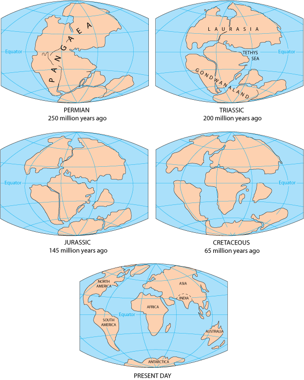
The fault, which runs the length of the west coast of Sumatra about 200-kilometres offshore, is the meeting point of the Eurasian and Pacific tectonic plates, which have been pushing against each other for millions of years. This can cause huge stresses to build up.

"There is a strong indication this foreshadows the big one," said Danny Hillman, an earthquake specialist at the Indonesian Institute of Science. "We all agree there is an 8.5 or stronger earthquake waiting to happen."

The image “http://pubs.usgs.gov/gip/dynamic/graphics/Fig1.gif” cannot be displayed, because it contains errors.

Especially when idiots in the region insist on testing nuclear weapons.
Or creating mud volcanoes from petroleum exploration. Thus adding a man made element to the mix.


Geothermal plants would tap 'Ring of Fire'

The Pacific Northwest, which sits on the volcano-laden "Ring of Fire" bordering the Pacific Ocean, would seem an obvious spot to pursue geothermal power.

For Gordon Bloomquist, it has been obvious for nearly 30 years. He and others have estimated that by capturing the Earth's subterranean heat and converting it into electricity, they could generate enough power for 2 million homes.

But, only now, as the Washington State University geochemist prepares to retire and take his talents to work on geothermal projects for the World Bank in Eastern Europe and Africa, does it look as if this region may be pushed to exploit the hot-rock power lurking beneath our feet.


Speaking of geo-thermal energy and climate warming let's not forget that this is the region that produced Krakatoa.

However, Becker said, a leaky tectonic quilt on average would lead to greater volcanic activity, earthquakes and plate movement. This would affect almost every aspect of Earth's geography, from sea level to erosion to climate.

"There's sort of a chain of things that follows from a good mechanical understanding of how plate tectonics works," he said.


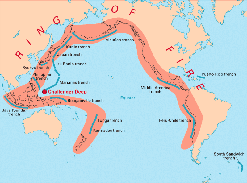
Like the proverbial butterfly effect, what happens in the core of the Ring of Fire affects us too.

'Ring of Fire' asserts power with tremor
Times of India, India - 16 Aug 2007

Peru has become the latest country to feel the renewed heat from the ‘Ring of Fire’ that unleashes earthquakes around the Pacific almost every day.

At least 337 people were killed after the 7.9-magnitude quake rattled the country on Wednesday. The Ring of Fire stretches along the western coast of the Americas through the island nations of the South Pacific and on through Southeast Asia. It is a series of fault lines in the hardened upper layers of the Earth’s crust.

These lines of weakness are the meeting points of huge continental plates that make up the crust and which literally float on the molten rock of the Earth's core.

These plates are in constant motion, clashing into each other or moving away from each other, creating stresses and pressure build-ups at their margins.

This stress is released through volcanic eruptions, when the molten rock is ejected as magma through fissures in the crust, or via earthquakes, when the pressure causes the crust to buckle and shift.


Two days ago reports fluctuated as to whether the quake was 8.4 or 7.9
it all depended on where it was registered.

But that should have set off warning bells that apparently there were overlapping quakes leading to the next two days of so called after-shocks which were more like quakes than shocks.
A massive magnitude 8.4 earthquake hit southern Sumatra's Bengkulu province Wednesday at 6:10 pm local time. It was followed by 51 tremors, including one in western Sumatra's Jambi province Thursday morning that was measured at a magnitude of 7.8. The severe quakes rattled buildings in three countries and triggered tsunami warnings across the Indian and Pacific oceans.

The powerful earthquake of 7.9 magnitude that struck off the coast of Indonesia had its epicentre about 100 km southwest of Bengkulu.

According to R.K. Chadha, scientist with the National Geophysical Research Institute, Hyderabad, the fault plane was in a northwest-southeast direction. The focus (where the plate rupture actually takes place inside the earth) was at a depth of about 30 km from the ocean floor.


http://blog.wired.com/photos/uncategorized/2007/09/12/tsunamiwarning_2.jpg


“The length of the fault plane should not be more than 250 km. Its epicentre is 300-400 km further south of the December 2004 quake,” Dr. Chadha said. The 2004 earthquake caused a rupture 1200 km long and pushed the Burma plate by 15 m for the entire length of the fault.

In 2004, the focus was 10 km, and hence it was a shallow earthquake. Unlike deep quakes, shallow ones cause more damage. A tsunami that results from such quakes can be more powerful and widespread compared to deep-seated earthquakes.

The quake that struck at 6.10 p.m. local time on Wednesday had a magnitude of 7.9-8, while that of the 2004 quake was 9. With magnitude being measured on a logarithmic scale, a magnitude difference of one translates to a quake 10 times more powerful.

Though a tsunami can be generated even by a shallow quake of 6.5 magnitude, maximum tsunami energy will always be focussed in the direction perpendicular to that of the fault plane. With the fault plane of Wednesday’s quake lying in a northwest-southeast direction, the maximum energy dissipation would have been in the same direction.

Unlike in 2004, where the direction of energy dissipation from the fault plane was nearly parallel to the Indian coast, maximum energy dissipation from the current quake would not have been in the direction of the Indian coast but into the open ocean. On the northeast direction, the energy dissipation would have been towards Bengkulu island.

Following the 2004 quake, another earthquake of 8.7 magnitude struck off the coast of Sumatra on March 28, 2005, about 200 km south of the 2004 event. It happened in the same subduction zone. “We call this as loading and unloading of stress,” said Dr. Chadha. “When stress is released at one point, it accumulates at another point. And, we had predicted that another quake would strike further south of the March event.”

The latest quake was in the same subduction zone, and lies further south of the March 2005 event.


SEE:

Earth in Upheaval-Updated


Find blog posts, photos, events and more off-site about:
,
, , , ,
, , , , , , ,
, , , , , ,
, , , , , , , , , , , , , ,
, , , , , , , , , , , , , , , , , ,

Wednesday, July 25, 2007

Serpent Geology

It was. Hundreds of millions of years ago.

Western North America may have once been joined to Australia, a hypothesis that a local mining exploration company is banking on to help it find riches in the Yukon.

The theory is that if Australia and the Yukon were once joined, the two areas would share some geological DNA. So what is happening mineral-wise in Australia may also be happening in the Yukon.

And what's happening in Australia is the Olympic Dam mine, a multi-mineral ore body that includes the world's largest uranium deposit and fourth-largest remaining copper deposit, as well as significant amounts of gold and silver.


Due to plate tectonics the plates under the continents slip and slid over and under and along each other.

Thus producing widely separated rock formations common in many mountain regions, like ophitic rocks and serpentines. And so living in areas where the earth is alive and active, rather than dormant, humans associated the ever present geological striations of the earth with serpents the oldest diety/fetish we have.

To early humans the earth was alive, rock art representations of serpents, as well as the idea of painting with ophitic stone pigments on ophitic stone, showed a reverence for the sacred space that was stone walls, stone outcrops, the serpent image carved out of the serpent forces around us. Which gives new meaning to Snakes On A Plain.


In geologic terms, a plate is a large, rigid slab of solid rock. The word tectonics comes from the Greek root "to build." Putting these two words together, we get the term plate tectonics, which refers to how the Earth's surface is built of plates. The theory of plate tectonics states that the Earth's outermost layer is fragmented into a dozen or more large and small plates that are moving relative to one another as they ride atop hotter, more mobile material. Before the advent of plate tectonics, however, some people already believed that the present-day continents were the fragmented pieces of preexisting larger landmasses ("supercontinents"). The diagrams below show the break-up of the supercontinent Pangaea (meaning "all lands" in Greek), which figured prominently in the theory of continental drift -- the forerunner to the theory of plate
tectonics.


5globes.gif

According to the continental drift theory, the supercontinent Pangaea began to break up about 225-200 million years ago, eventually fragmenting into the continents as we know them today.


Find blog posts, photos, events and more off-site about:
, , , , , , , , , , , , , , , , ,, , , ,
,
, , , ,
, , , , , , ,

Monday, February 05, 2007

Man Made Volcano

As if Indonesia did not have enough environmental problems; 340000 flee deadly floods in Jakarta, now we find out that the mud spewing volcano that erupted last year is a man-made phenomena.


Mud
The Indonesian volcano, known as Lusi, has been spewing steaming mud since May last year, causing 13,000 people to flee their homes (Image: University of Durham)
Drilling for gas most probably caused the eruption of an Indonesian mud volcano, forcing the evacuation of thousands of people, scientists report.

"[The eruption] appears to have been triggered by drilling of over-pressured porous and permeable limestones at depth of around 2830 metres below the surface," says the study, the first published on what caused the eruption.

The study, which appears in the February issue of the journal GSA Today, adds that the volcano has been disgorging 7000-150,000 cubic metres of mud every day since it erupted in May last year.

Such pressures, coupled to the local geology, suggest the flow "will continue for many months and possibly years to come", warn the UK researchers, led by Professor Richard Davies from the University of Durham.

In the coming months, sag-like subsidence several kilometres wide will occur, and around the main vent there is likely to be "more dramatic collapse", forming a crater, the study adds.

An area of at least 10 square kilometres around the volcano will be uninhabitable for years, and over 11,000 people will be permanently displaced, it says.


Add to that the wildfires started by slash and burn operations for palm oil plantations and the continuing disruption and displacement from the 2004 Tsunami and Indonesia is an ongoing environmental disaster.

But do plan to take your holidays there, I hear it is quite nice otherwise.

See

Indonesia

Palm Oil

Borneo


Disasters

Environment

Volcano

Tsunami


Find blog posts, photos, events and more off-site about:
, , , , , , ,