BAN DEEP SEA MINING
Japan Demands Chinese Research Vessel Stop Unauthorized Activity in EEZ
Japan is reporting its first altercation of 2026 with vessels from China operating in the disputed region around the uninhabited islands it calls Senkaku, and China is making claims to as the Diaoyu islands. The Japan Coast Guard reported detecting a research vessel and then said four China Coast Guard vessels also entered the disputed zone. Japan administers the zone.
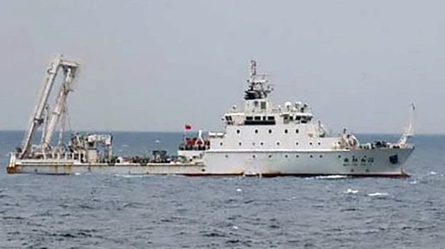
The research vessel Xiang Yang Hong 27 (3,300 gross tons) was detected entering Japan’s EEZ on Tuesday afternoon, March 31. The Coast Guard reported the vessel, which was built in 2019 and is 89 meters (292 feet) in length, was located about 60 to 70 kilometers (37 to 44 miles) north of Uotsuri Island. It was spotted “extending pipe-like equipment from both sides of the ship and wire-like equipment from the stern into the sea.”
The Japan Coast Guard issued a radio challenge to the vessel. It demanded that it cease all activity, asserting the vessel required a permit from Japan to conduct any research in the area. The Coast Guard said it would continue to monitor the movement of the vessel.
The initial report of the research vessel was followed up on April 1 with a statement from the Japan Coast Guard, which said four China Coast Guard vessels had entered its territorial waters, also near Senkaku. It said the incident took place from about 0600 to 0620, and the ships had left the zone one after the other.
The Japan Coast Guard reports the Chinese vessels have been operating for 138 consecutive days around Senkaku. It said the four vessels, Haijing 2303, Haijing 2302, Haijing 2401, and Haijing 2307, were observed with machine guns. They said it was the first time they had observed 2308 sailing in the vicinity of Senkaku.
Tensions with China have increased since Japan’s new prime minister, Sanae Takaichi, talked about Japan’s willingness to defend Taiwan. Reports said it was the first confirmed sighting of a Chinese research vessel in the area since May 2025. However, in August and again in December, Japanese and Chinese coast guard vessels reported encounters and standoffs in the same region around Senkaku. In December, a Japan Coast Guard vessel positioned itself between fishing vessels and a China Coast Guard vessel and ordered the Chinese vessel not to approach. The Japan Coast Guard vessel had stayed with the fishing boats until the Chinese vessels sailed away.
China's Deep Sea Mining Research May Be Cover for Surveillance
[By Elizabeth Claire Alberts and Kara Fox]
A Mongabay and CNN investigation found the eight Chinese state-owned ships that conduct deep-sea mining research in China’s mining areas allocated by the International Seabed Authority (ISA) actually spent little time in these exploration areas, while spending much of their remaining time operating in militarily strategic waters.
Many of these vessels are linked to the Chinese Navy, have regularly called on military-connected ports, encroached on other countries’ coastal exclusive economic zones and turned off their AIS location beacons. While none of this proves the vessels serve military roles, it suggests the ships may serve dual-use purposes, having a strategic military role as well as a scientific one.
With China positioning itself as a leader in deep-sea mining, the U.S. is accelerating its own push to access seabed areas and counter China’s dominance in critical mineral supply chains. The Cook Islands is one hotspot where U.S-China competition is intensifying.
As competition heightens between China and the U.S., critics of the industry warn deep-sea mining could cause irreversible harm to marine ecosystems, raising fears that the environment could be the main casualty in this geopolitical rivalry.
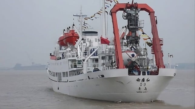
In June 2025, the Xiang Yang Hong 01, a chalky white vessel loaded with oceanographic equipment, cruised the Northwest Pacific until it reached a section of the seafloor rich in polymetallic nodules — potato-shaped rocks that contain valuable metals such as manganese, nickel, cobalt and copper. The ship zigzagged over the site, conducting research in the area miners could eventually exploit through deep-sea mining, a controversial industry that experts warn could irreparably harm marine ecosystems.
Since entering service in 2016, the Xiang Yang Hong 01, which translates as Facing the Red Sun 01, has gone on several deep-sea mining research expeditions in the Northwest Pacific. Yet, over the past five years, the Chinese state-owned ship spent far more time outside designated deep-sea mining exploration areas and logged extensive trips in militarily strategic waters. This vessel has also gone “dark” numerous times over the past five years, possibly disabling its automatic identification system (AIS) while operating in strategically sensitive ocean areas, according to New Zealand-based Starboard Maritime Intelligence.
“These gaps are significant,” Mark Douglas, an analyst for Starboard Maritime who is also in the New Zealand naval reserves, told Mongabay and CNN in an email. He said the Chinese ship “demonstrates a deliberate pattern of operating in sensitive areas, outside the view of traditional tracking systems.”
The result is a pattern that, experts say, shows the ship may be more interested in mining military intelligence than deep-sea minerals.
A spokesperson for China’s Ministry of Foreign Affairs did not address questions about the activities of the Xiang Yang Hong 01 or the potential military uses of its oceanographic research vessels. In a statement to Mongabay and CNN, the ministry said, “Within the framework of the International Seabed Authority (ISA), China conducts activities in deep-sea exploration, scientific research, and environmental protection, assisting a host of developing countries in effectively strengthening their deep-sea capacity building. This is in accordance with the provisions of the United Nations Convention on the Law of the Sea.” It added that China “highly values deep-sea environmental protection.”
Mongabay and CNN tracked eight Chinese research vessels that have undertaken deep-sea mining exploratory missions over the past five years. During that period, the ships spent just around 6% of their total open water time in or near areas reserved by Chinese companies for deep-sea mining exploration, according to an analysis of data from MarineTraffic, a ship tracking provider, and the data platform Deep Sea Mining Watch.

The exploration areas are licensed by the ISA. Although the body has not yet finalized international regulations for deep-sea mining and commercial extraction has yet to begin, China has positioned itself as a global leader, holding five of the 31 exploration contracts issued by the ISA and serving as its largest financial contributor. The ISA told Mongabay and CNN by email that the “amount of contribution by a member State is not relevant to the number of the exploration contracts signed or sponsored by the member State.”
Many of the ships tracked by Mongabay and CNN are tied to state-affiliated entities with links to the Chinese Navy, known as the People’s Liberation Army Navy, and regularly call on military-connected ports. Some have also visited other countries’ exclusive economic zones, possibly to conduct surveillance, often without permission. Others have displayed patterns suggesting attempts to avoid detection, including “going dark” by failing to transmit their mandatory AIS signals that broadcast a vessel’s identity and position, possibly intentionally.
While none of this proves the vessels serve military roles, it suggests the ships may serve dual-use purposes, having a strategic military role as well as a scientific one. This thesis was supported by more than a dozen naval and military experts interviewed for this story. Mongabay and CNN reached out to multiple Chinese agencies and institutions, but none responded to questions about dual-use activities by China’s oceanographic research vessels.
“They want to know what’s going on at the bottom of the sea, where U.S. submarines might go, where their submarines might go, where other submarines might go,” Raymond Powell, a retired U.S. Air Force colonel and executive director of SeaLight, a nonprofit that focuses mainly on China’s maritime military activities, told Mongabay and CNN. “Mapping the seafloor in those places is going to be of intense interest to them.”
These alleged dual-purpose vessel missions appear to align with China’s broader pursuit of “maritime power” — a goal Chinese leader Xi Jinping first articulated in 2012, shortly after taking office, and reiterated over the years. Some analysts say China views the deep seabed, and the exploitation of its minerals, as its next frontier. In response, the U.S. is rushing to mine the deep seabed, with a stated goal of countering China’s dominance in the sector. The U.S. is backing up the move with a $12 billion investment fund to spur mining and boost the nation’s hold on critical minerals.
Alexander Gray, who served in the first administration of U.S. President Donald Trump as a deputy assistant to the president and chief of staff of the White House National Security Council, said the U.S. government has “a very real concern” about the potential dual uses of China’s research vessels. While previous administrations have been worried about these developments, he said the Trump administration is particularly focused on them.

A Brisingid starfish on rock surface with botryoidal manganese nodules. Image by NOAA/OAR/OER, 2016 Deepwater Exploration of the Marianas, Leg 3.
Gray told Mongabay and CNN that the U.S. government is also concerned about China’s attempt to monopolize critical minerals.
“China [is] using critical minerals as a tool of economic coercion against the United States,” Gray said, adding that the U.S. should “diversify supply through deep-sea mining” to generate “resilience” to withstand China’s actions. “That, I think, very much justifies this speeding forward on this development,” he said.
The U.S. Department of State did not respond to questions seeking further detail on how competition with China is influencing the United States’ pursuit of deep-sea mining. China’s Ministry of Foreign Affairs also did not respond directly to questions about U.S.-China competition for deep-sea minerals.
As both China and the U.S. pursue deep-sea mining, critics of the industry, including government officials, scientists and environmentalists, warn the marine environment could be the loser in this race to the bottom of the ocean.
China’s growing influence in the ocean
To examine China’s deep-sea mining activities, Mongabay and CNN, with the support of the Pulitzer Center, tracked eight Chinese vessels that have undertaken deep-sea mining exploratory missions during the five years, from January 2021 to January 2026. These are the only Chinese research ships that have visited China’s ISA-designated mining areas since 2021, the period most relevant to current geopolitical tensions and developments in deep-sea mining.
There are at least 32 additional vessels in China’s oceanographic research fleet that have traveled across the global ocean, from the poles to the tropics, according to the China Maritime Studies Institute, a research center at the U.S. Naval War College in Rhode Island. The experts Mongabay and CNN interviewed for this story say this broader oceanographic fleet not only studies oceanic phenomena but also undertakes missions that serve China’s military and strategic objectives. This research fleet is considered to be the largest in the world, although other countries, such as the U.S., also have sizable research fleets.

Most of the ships in China’s research fleet are owned and operated by state agencies, including the Ministry of Natural Resources. All rely on state funding, which includes initiatives that focus on deep-sea exploration, minerals and Chinese national security.
While China’s research fleet has traversed the world’s oceans, conducting bathymetric surveys to map the seafloor, China has contributed relatively little data to the public. Chinese organizations and research institutions contributed 41 data sets to a public data sharing effort on the world’s seas known as the General Bathymetric Chart of the Oceans (GEBCO), according to Pegah Souri, the head of external relations of Seabed 2030, a collaborative project between GEBCO and The Nippon Foundation. This accounts for roughly 0.7% of the total contributions to the global seabed mapping initiative. China’s Ministry of Foreign Affairs did not respond to questions about its contributions.
The locations analyzed for this story include China’s five areas licensed to three Chinese state-controlled entities: China Minmetals Corporation, Beijing Pioneer Hi-Tech Development Corporation Ltd. and China Ocean Mineral Resources Research and Development Association (COMRA). These five licensed areas give China more ISA contracts than any other member state, covering approximately 225,000 square kilometers (86,900 square miles), roughly three times the size of Ireland.
The analysis also includes a roughly 74,000-km2 (28,500-mi2) reserve area in the Pacific. Beijing Pioneer was required to conduct surveys and submit the resulting data to the ISA in 2018. The following year, in 2019, it gave this reserve area to the ISA to benefit developing nations in the future. But despite the transfer, Chinese vessels have remained active in and around this area, even though it is no longer required to submit data.
Over a five-year period, these eight Chinese ships spent a combined 814 days operating in or near these areas licensed or reserved for exploration by the ISA.
Within these areas, the vessels traveled a combined 102,000 km (63,400 miles) — more than twice the circumference of the Earth. News coverage and corporate documents confirm these ships were conducting deep-sea mining-related research while visiting these ISA areas, including collecting samples of sediment and organisms. COMRA, Beijing Pioneer and China Minmetals did not respond to questions about the scope of their research.
Other countries and companies hold an additional 26 exploration contracts covering a combined 1.2 million km2 (almost 470,000 mi2). There are also 890,000 km2 (nearly 345,000-mi2) that the ISA keeps on reserve for possible future exploitation by developing countries.
In the Clarion-Clipperton Zone (CCZ), a region about as wide as the continental United States, located between Hawaii and Mexico and known to harbor vast quantities of nodules, the ISA established “areas of particular environmental interest,” where no mining can take place. They add up to about 1.9 million km2 (760,000 mi2). Separately, the U.S. has issued an exploration license to defense company Lockheed Martin for a total of 232,000 km2 (90,000 mi2) in the CCZ, using the authority of a 1980 law known as the Deep Seabed Hard Mineral Resources Act (DSHMRA), which established a legal framework for U.S. citizens to pursue deep-sea mining activities in international waters. Over the past year, other companies have announced that they have applied for similar licenses.
Chinese ships sail far to French, Polish and other mining sites
The eight Chinese exploration ships are not going just into areas contracted to Chinese companies — they are also spending time in places that the ISA licensed to non-Chinese companies and governments and reserve areas. This is permitted under international law.
For instance, in December 2023, the Shen Hai Yi Hao — a vessel that was built to carry the Jiaolong, one of China’s biggest manned submersibles — began a journey of more than 25,000 km (15,500 mi) from eastern China to the North Atlantic. The vessel appeared to conduct oceanic exploration along the journey. Some missions stand out: During March and April 2024 it operated around three ISA areas contracted separately to France’s research institute IFREMER, Poland and Russia. In November 2025, the same vessel lingered in a swath that the ISA licensed to South Korea.
Representatives from IFREMER, Poland and South Korea said the research activity is allowed under international law. IFREMER and Poland representatives also confirmed they had been notified ahead of the Shen Hai Yi Hao’s visit. Russia did not respond to a request for comment.
The ISA said it had no information whether the Shen Hai Yi Hao was passing through these areas or if they conducted surveys.
The National Deep Sea Center of China, which owns and operates the Shen Hai Yi Hao, did not respond to questions about this voyage.

Model of Jiaolong submersible at the Five-Year Achievements Exhibition. Image by N509FZ via Wikimedia Commons (CC BY-SA 4.0).
Darshana Baruah, an expert in Indo-Pacific defense and strategy at the International Institute for Strategic Studies (IISS), told Mongabay and CNN that Chinese vessels gather more than scientific data. She said they go to other ISA areas for strategic information.
“The scientific data that you pick up in the underwater domain can be applied across different areas,” Baruah said. “Being present in those waters would give them a far broader understanding of the geopolitics of the region, the logistics of sailing, the logistics of maintaining that presence, if they wish to.”
China has also spent time conducting deep-sea mining research in other waters. For instance, in 2021, China tested a nodule collection system in the East China Sea and South China Sea. In 2025, China also announced plans for constructing a laboratory capable of operating roughly 2,000 meters (6,500 feet) beneath the South China Sea. The research station, due for completion in 2030, will focus on cold-seep ecosystems — critical for understanding energy resources including hydrocarbon and gas hydrate reservoirs — while also reinforcing Chinese reach in one of the world’s strategically contested maritime regions.
While deep-sea mining exploration is ongoing, neither China nor any other nation has begun deep-sea mining on a commercial scale. In the international sphere, this is largely due to the fact that the ISA has yet to adopt regulations that would allow exploitation to proceed in areas beyond national jurisdiction. In addition, nodule processing at a commercial scale is still in its infancy.
U.S. accelerates plans to mine the deep sea
The U.S., meanwhile, is pressing forward with its ambitions to begin undersea mining in international waters.
Representatives from China and other nations, as well as the ISA, have said the U.S. would be violating international law. A spokesperson from China’s Ministry of Foreign Affairs told Mongabay and CNN that “according to international law, the international seabed area and its resources are the common heritage of mankind, and no country may bypass the ISA to independently authorize exploration or development activities.”
“China urges the United States to heed the voices of the international community, to pull back before it is too late, change course, respect the international seabed system, and uphold the overall interests of the international community,” the spokesperson added.
The U.S is not a member of the ISA and has not ratified the U.N. Convention on the Law of the Sea (UNCLOS). It is classified by the ISA as only a nonvoting observer. The U.S. State Department said in a statement to Mongabay and CNN that it is “committed to the responsible development of seabed mineral resources” and that the UNCLOS “framework for deep seabed mining does not apply to non-parties like the United States, carries no weight under customary international law” and claimed it “has become a tool of malicious actors.”
Since Trump returned to the presidency in 2025, the U.S. government has argued that it needs deep-sea minerals for its national security and to counter Chinese mineral dominance.
In April 2025, Trump signed an executive order titled “Unleashing America’s Offshore Critical Minerals and Resources” that calls for accelerating the industry in both domestic and international waters.
On Jan. 21, the U.S. National Oceanic and Atmospheric Administration (NOAA) approved a controversial rule that would expedite licensing and permitting.
The U.S. is pressing forward on other fronts. In its territorial waters, the U.S. Bureau of Ocean Energy Management has advanced efforts to pursue deep-sea mining near American Samoa, the Northern Mariana Islands and off the coasts of the U.S. states of Virginia and Alaska, including the Aleutian Islands, prompting local and environmental opposition. The U.S. also partnered with Japan to test the extraction of deep-sea muds rich in rare earth elements — crucial minerals for weapon systems — around Minamitori Island, which lies in Japan’s EEZ and serves as a military base. China currently dominates the global market share of production and processing of rare earth elements.
Many of these places, especially in the Pacific, carry strategic significance for U.S. military competition with China. Neither the U.S. State Department nor the White House responded to questions about whether pursuing mining in these areas was also about mineral dominance, in addition to seabed resource extraction. China also did not respond to questions regarding this matter.
While some ships in NOAA’s fleet have supported the U.S. Navy and broader national security interests through data sharing and collaborative research, it is unclear whether vessels involved in deep-sea mining track Chinese submarines or perform similar military work. Experts interviewed for this story said they found no evidence that U.S. deep-sea mining ships conduct surveillance missions. The U.S. Navy operates vessels specifically designed for maritime surveillance. Neither NOAA nor the U.S. Navy responded to questions for this story.
‘Inviting environmental disaster’
As plans to mine the ocean floor progress, a growing number of scientists, environmentalists, companies and nations warn that mining could irreparably damage ecosystems that have evolved over millions of years and host an extraordinary kaleidoscope of life forms.
A Chinese-led research project, which utilized China’s deep-sea submersible Fendouzhe in 2021, identified 7,564 species of hadal prokaryotic microorganisms — tiny organisms that play a crucial role in the marine food web by cycling nutrients. Nearly 90% of these species were previously unknown.
Meanwhile, a study published in March 2025 in Nature found that 44 years after a mining test, biodiversity had still not fully recovered.
Another study, published in December 2025 in Nature Ecology & Evolution, estimated that industrial-scale deep-sea mining tests done in 2022 caused a 37% reduction in animal abundance within the directly mined areas of the Pacific’s CCZ.
Critics of deep-sea mining also point out that very little is known about the deep sea and its marine life.
Emily Jeffers, senior attorney at the Arizona-based nonprofit Center for Biological Diversity, said U.S. plans to fast-track the start of deep-sea mining were “inviting an environmental disaster.”
She is not alone worrying about the ecological toll. Environmental attorney Lori Osmundsen, based in Oregon, said she doesn’t have confidence the Trump administration will adhere to environmental laws.
Isaac Kardon, a senior fellow for China studies at the Carnegie Endowment for International Peace, said he believed China has a similar stance.
“China says nice things about the environment, but it’s very obviously committed to pushing forward,” Kardon said. “They’re not going to accept environmental impact reports or whatever that are not supportive of proceeding with drilling.”
Those in favor of deep-sea mining say minerals are desperately needed for a modern society. They argue that certain minerals found on the ocean floor are harder to procure on land, such as nickel and cobalt, and that deep-sea mining would be less destructive to the environment and human rights. They also advocate the many uses of deep-sea minerals — from renewable energy technologies such as electric vehicle batteries to a wide range of military applications.
More than a mineral race?
But the ships followed by Mongabay and CNN appear interested in more than deep-sea mining, according to more than a dozen naval, civil and academic experts.
Mongabay and CNN’s data analysis found the eight vessels only spent 6% of their sea time in ISA-designated deep-sea mining areas. The rest of the time, they were circumnavigating large swaths of the ocean, transiting through politically sensitive areas such as waters near Guam or China’s overlapping claim with Taiwan. The majority of analysts interviewed for this story said they believed these vessels were collecting information that could include military intelligence. The ships may have been gathering information that might be used in warfare, such as locating telecommunications cables that could be severed and gathering information to track another country’s submarines, the analysts said.
Routes, surveys and sound pollution
Another of the eight Chinese research ships apparently mapped areas around Guam and the Mariana Islands.
Between February and May 2024, the Xiang Yang Hong 06 appeared to scan a roughly 44,000-km2 area (17,000 mi2) of the seabed, just west of Guam, a U.S. territory that is home to Andersen Air Force Base, a key base for long-range bombers and a port for U.S. nuclear attack submarines that could be vital to defend Taiwan. The vessel tracks indicated the Chinese ship was moving in what analysts described as a lawnmower pattern, likely surveying the undersea features below.
Michael Jasny, an expert on ocean noise pollution at the New York City-based Natural Resources Defense Council, said that based on the vessel’s movements, the ship was likely conducting a survey using a “lower-frequency multibeam system.”
This technique can cause substantial harm to cetaceans such as whales, he said.
“What concerns me in this case is the potential exposure of large, understudied areas of ocean to disruptive noise,” Jasny told Mongabay and CNN in an email following our interview.
“These ships are probably using very powerful echosounders if they mean to map the seafloor four thousand meters down — systems that are known to silence whales and even cause animals to strand in some circumstances. From the standpoint of ocean life, they may be shooting first and asking questions later, if at all.”
The Ministry of Natural Resources’ North China Sea Bureau, which owns and operates the Xiang Yang Hong 06, did not respond to questions about the ship’s activities, the nature of its work or if they mitigate environmental impacts.
The Xiang Yang Hong 06 eventually reached the Philippine Sea, where it traveled along the east coast of Taiwan, the island nation whose independence is a long-standing source of friction with China. The ship followed a path that other Chinese oceanographic vessels have taken, traveling slowly along the Taiwanese seaboard.
In February 2024, the vessel Da Yang Hao made a similar route up the east coast of Taiwan, tracing parallel lines for five days. Experts suggest the vessel could have been acoustic monitoring, taking the sound profile of the area, which can be helpful for finding submarines. COMRA, which owns the Da Yang Hao, did not respond to a request for comment.
“You just suspect that they’ve got some extra ears listening in for certain things that they’d like to know about,” said Powell of SeaLight.
Chinese vessels by Taiwan
The vessels that Mongabay and CNN analyzed went on many other journeys that seemed to stretch beyond the realm of scientific discovery.
For example, in November 2023, the Xiang Yang Hong 03 spent 48 hours doing survey work over a known transpacific cable, covering around 400 square nautical mi (about 1,400 km2 or 530 mi2), smaller than other surveys the vessel conducted.
The vessel “made a fairly direct line straight to one particular part of the ocean,” where undersea cables had been laid three years prior, Douglas of Starboard said. It continued to do “what looks like to be a very focused little bit of survey work over the course of a couple of days over top of the cable,” before it left the area, he said.
Douglas called the vessel’s movements around the cables “a smoking gun” that it was gathering strategic intelligence.
China’s Third Institute of Oceanography, part of the Ministry of Natural Resources, owns and operates the Xiang Yang Hong 03. It did not respond to a request for comment.
Another incident occurred in May 2023 when the Hai Yang Di Zhi Liu Hao entered Palau’s EEZ without authorization and slowed two knots while passing over Palau’s fiber optic cable — a behavior Palauan officials called “questionable.” The China Geological Survey, which owns the Hai Yang Hi Zhi Liu Hao, didn’t respond to questions about this incident.
China has previously been charged with sabotaging undersea cables. In 2025, Taiwan jailed the Chinese captain of the cargo ship Hong Tai 58 for damaging undersea cables that connect Taiwan’s main island and the Penghu islands in the Taiwan Strait. The captain denied wrongdoing, according to published reports. He admitted that he ordered his crew to drop anchor, which damaged the cables, but that he was merely negligent in his duties as captain.
A spokesperson for China’s Taiwan Affairs Office said earlier this year that damage to undersea cables is not unusual, describing such incidents as “common maritime accidents.”
China’s oceanographic vessels have also appeared to go on strategic missions in Russian waters.
In August 2024, the vessel Ke Xue — a deep-sea mining vessel that completed its last mission to an ISA-designated area in 2018 — entered the Bering Sea and lingered. Ryan D. Martinson of the U.S. Naval War College’s China Maritime Studies Institute wrote in a report that the vessel appeared to be collecting data, installing moored instruments or even deploying submersibles.
The Ke Xue also cruised by Alaska’s Aleutian Islands, within the U.S. EEZ, three times before returning to Qingdao. A spokesperson for the U.S. State Department told Mongabay and CNN that it “did not receive an application from China for this vessel to conduct marine scientific research” near the Aleutian Islands in August 2024. China’s Institute of Oceanology, which owns and operates the Ke Xue, did not respond to Mongabay and CNN’s request for comment.
Xiang Yang Hong 01 made a similar journey, entering the Bering Sea in August 2024 and operating for several days inside Russia’s EEZ. During this visit, the Xiang Yang Hong 01 went into Avacha Bay, a key hub for Russia’s Pacific Fleet and submarine forces — an action Martinson called “rare” and “unprecedented” and suggestive of Russia-China maritime cooperation.
The Russian government did not respond to a request for comment on either of these instances. The Ministry of Natural Resources’ First Institute of Oceanography, which owns and operates the Xiang Yang Hong 01, also did not respond to questions.
U.S.-China competition in the Cook Islands
While experts interviewed for this story suggested that China’s deep-sea mining vessels may be engaged in broader strategic and potentially military missions, there is little evidence that deep-sea mining sites themselves have become places of strategic friction.
But there is one place where geopolitical deep-sea mining competition does appear to be playing out: the Cook Islands.
The Cook Islands are a small but strategically important archipelago that occupies a key position in the central Pacific, along major seafaring and data transmission routes. Its territorial waters also contain 6.7 billion tons of cobalt-rich polymetallic nodules, according to the Cook Islands Seabed Mineral Authority (SBMA), the regulator of the nation’s seabed mineral sector. The country is considering allowing miners to exploit its seabed, despite pushback from environmentalists.
Deep-sea mining exploration is already taking place in the Cook Islands. In 2022, the SBMA issued three deep-sea mining exploration licenses to three different companies, including some with U.S. ties.
Then China made its move. In February 2025, China signed four agreements with the Cook Islands, including a memorandum of understanding on deep-sea mining research.
This resulted in a quarrel with Aotearoa New Zealand, a close ally of the United States. The Cook Islands has a close relationship with New Zealand, including getting foreign aid, yet New Zealand eventually halted funding to the Cook Islands over the China deals.
In the months that followed, the U.S. responded to China’s move. On July 31, the U.S. Federal Bureau of Investigation announced it opened a new office in Wellington, New Zealand, to expand its reach in the Pacific and counter Chinese influence in the region. Barely a week later, on Aug. 5, the U.S. and the Cook Islands issued a joint statement of cooperation on the seabed mineral sector. Then, in October, a NOAA-funded vessel, the E/V Nautilus, traveled to the Cook Islands to conduct a 21-day deep-sea research expedition, which included a mineral survey of the EEZ that month.

In November, the Da Yang Hao, an oceanographic ship linked to Chinese naval interests, also traveled to the Cook Islands to conduct deep-sea research.
Baruah of IISS said she believes these developments underscore the geopolitics surrounding the Cook Islands’ desire to pursue deep-sea mining.
“Cook Islands is quite strategically located, as are most of the islands in the South Pacific,” Baruah said. “Countries are more and more conscious and concerned about a dual-purpose, dual-use of leveraging non-military initiatives for intelligence gathering or domain awareness or research purposes.”
The U.S. State Department, the Cook Islands Seabed Minerals Authority and China’s Ministry of Foreign Affairs did not respond to requests for comment on these incidents.
For some on the Cook Islands, the moves by the United States and China have raised alarms.
“We are concerned that the Cook Islands is becoming a melting pot between two major states facing off against each other by equipping themselves with deep-ocean minerals that could be used to support their military defense,” Alanna Matamaru Smith, director of the Te Ipukarea Society, told Mongabay and CNN.
“These states don’t care about us or the long-term environmental impacts they may leave behind,” Smith added. “They only care about protecting themselves.”
Elizabeth Claire Alberts is a senior staff writer for Mongabay and was a 2024-25 fellow with the Pulitzer Center’s Ocean Reporting Network. Find her on Blueskyand LinkedIn.
Kara Fox is a senior reporter at CNN International and a guest contributor to the Pulitzer Center.
Yong Xiong, Lou Robinson and Joyce Jiang of CNN contributed to the reportinzg of this story. Kuang Keng Kuek Ser and Fernanda Buffa of the Pulitzer Center also contributed to the reporting of the story.
This article was produced in partnership with CNN with support from the Pulitzer Center’s Ocean Reporting Network, where Elizabeth Claire Alberts was a fellow. It appears courtesy of Mongabay and can be found in its original form here.
Top image: Boloomo / CC BY SA 3.0
The opinions expressed herein are the author's and not necessarily those of The Maritime Executive.