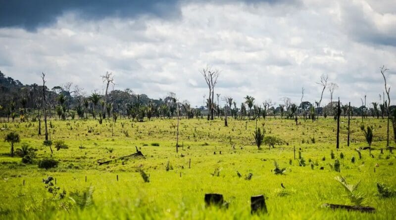
Deforestation in Brazil. Photo Credit: MARCELO CAMARGO/AGÊNCIA BRASIL
August 12, 2026
ABr
By Fabiola Sinimbu
ABr
By Fabiola Sinimbu
Key Takeaways
Native vegetation cover in Brazil has fallen from 79 percent of the territory in 1985 to 65 percent in 2025, with forests losing the largest absolute area (65 million hectares) and savanna ecosystems suffering the greatest proportional loss (30 percent).
During the most intense El Niño events of the past four decades, most Brazilian biomes experienced rainfall deficits (especially the Amazon), while agricultural areas often faced the strongest impacts; the Pampa, by contrast, saw excess rainfall.
Agriculture and livestock farming expanded from 18 percent to 32 percent of Brazil’s territory, driving the bulk of native vegetation loss—particularly in the Amazon and Cerrado—while 25 of 27 states recorded net declines in native cover.
Over the past 41 years, native vegetation has been reduced to cover 65 percent of Brazil’s territory, according to Collection 11 of MapBiomas’ annual land cover and land use maps, released this Wednesday (Aug. 12).


Over the course of these four decades, areas where forests remained intact were less affected by the El Niño phenomenon – the warming of the equatorial Pacific Ocean’s surface that causes extreme weather events in South America.
The new collection presents the results of mapping Brazil’s territory from 1985 to 2025, based on 33 land-cover classes, including biomes, human activities, vegetation types, and water surfaces.
In this edition, the data were cross-referenced with data from the MapBiomas Atmosfera platform, which monitors the country’s climate and air quality. The researchers paid particular attention to extreme weather events, such as droughts and storms, during the September–November period in El Niño Years – 1997/98, 2015/16, and 2023/24.
In their analysis, the researchers observed that, during the years when the phenomenon was most intense, most Brazilian biomes were affected by droughts and below-average rainfall.The exceptions were the Pampa biome and part of the Atlantic Forest, where precipitation increased.
Impact on biomes
The Amazon was the biome most affected by the rainfall deficit across the three El Niño events. During the most recent one, which occurred in 2023/2024, the most intense effects were recorded in agricultural areas. These regions, where humans have converted formerly forested land to other uses, experienced a 178-millimeter reduction in precipitation compared with the historical average.
The Pantanal was severely affected by the most recent El Niño event, making 2024 the driest year on record for the biome. In the Cerrado and the northern portion of the Atlantic Forest, the drought grew more intense with each successive El Niño event. Areas of native vegetation were the most affected in these biomes.
Agricultural areas were also the most affected in the Pampa by the extreme weather events associated with El Niño. However, unlike the Amazon, this biome was impacted by excessive rainfall, especially during the last two El Niño events analyzed.
Vegetation
In 1985, native vegetation covered 79 percent of Brazil’s territory, but by 2025, that percentage had fallen to 65 percent. Over those 41 years, forest ecosystems lost more area to human activity than any other type of vegetation, totaling 65 million hectares. They were followed by savanna ecosystems, which lost 46 million hectares, and wetlands, which lost 6.3 million hectares.
“Although the loss was greater in forests, proportionally, the greatest loss was in savanna ecosystems, which lost 30 percent of their total area during this period,” said Tasso Azevedo, general coordinator of MapBiomas.
Throughout the period studied, 557 million hectares of mapped land maintained the same land-cover or land-use class. Of this total, the majority – 335 million hectares – consisted of standing forests.
Human activities
Agriculture and livestock farming are the land-use category that occupies the largest area in Brazil. By 2025, they accounted for 32 percent of Brazilian territory, compared with 18 percent in 1985.
Pastureland increased by 61.6 million hectares over the study period, while cropland expanded by 48 million hectares.
These activities displaced native vegetation across Brazil’s six biomes to varying degrees. The Amazon and the Cerrado experienced the greatest losses, with reductions of 53.9 million and 51.7 million hectares, respectively.
The Caatinga, Atlantic Forest, Pampa, and Pantanal lost 10.1, 4.9, 4, and 1.9 million hectares, respectively.
“The Atlantic Forest lost less because it had already experienced previous losses and also because, over the past 20 years, it has stabilized and, in some places, the area of native vegetation – especially forests – has actually increased,” Azevedo explained.
Proportionally, however, the Cerrado and the Pampa showed the largest reductions, with losses of 34 percent and 32 percent, respectively.
States and the Federal District
When broken down by state, the new dataset shows that, between 1985 and 2025, 25 of Brazil’s 27 states saw a reduction in the proportion of native vegetation within their territories. Rio de Janeiro was the only state to recover 1 percent of its native vegetation cover.
Over these 41 years, the states that lost the most native vegetation relative to their total land area were Rondônia, where native vegetation cover declined from 92 percent to 59 percent from 1985 to 2025; Maranhão, where it fell from 91 percent to 61 percent; and Mato Grosso and Tocantins, where it declined from 90 percent to 61 percent.
New findings
Marshlands – wetland areas influenced by brackish water – were mapped for the first time in the MapBiomas study. In 2025, 6,900 hectares of these areas were mapped in the Pampa biome alone.
The main vegetation found in salt marshes is herbaceous, consisting of grasses and reeds adapted to saline conditions, as these ecosystems occur along the banks of estuaries and receive both freshwater from rivers or lagoons and seawater.
The sites included in the study are located in the estuarine zones of the Tramandaí-Armazém, Lagoa do Peixe, and Lagoa dos Patos lagoons, as well as at the mouth of the Arroio Chuí, all in the state of Rio Grande do Sul.
About ABr
Agência Brasil (ABr) is the national public news agency, run by the Brazilian government. It is a part of the public media corporation Empresa Brasil de Comunicação (EBC), created in 2007 to unite two government media enterprises Radiobrás and TVE (Televisão Educativa).
View all posts by ABr →

No comments:
Post a Comment