Megan Devlin
Nov 10 2021,

@parkboard/twitter
A larger-than-normal king tide has been flooding ocean-facing pathways around Vancouver this week. The latest place to become submerged is the Jericho Pier.
The Vancouver Park Board tweeted Tuesday that they’ve closed the pier for repairs after the tide rose above its wooden planks.
“We will post an update once it has safely reopened,” the Park Board said.
Video captured Tuesday morning shows a kayaker paddling very close to the area that’s normally dry land.
“You could dock a boat here,” resident Linds Rosso said in a video she took of the phenomenon.
You might also like:
Vancouver wants your photos of the king tides to predict the city's shoreline
27 majestic photos of King Tides in Metro Vancouver
King tides are extremely high tides that happen twice a year when the sun and the moon’s gravitational forces reinforce each other.
Daily Hive has reached out to the Park Board for more information on king tide damage this year but has not yet heard back.
Megan Devlin
Nov 9 2021

@lindsrosso/Instagram
Sections of the seawall surrounding Vancouver’s Yaletown and Kitsilano neighbourhoods were submerged Tuesday morning, much to the surprise of locals who enjoy walking along the waterfront path.
Sections of the seawall in David Lam Park were under several inches of water, leaving a wire fence meant to protect pedestrians sticking out of False Creek.
“You could dock a boat here,” Linds Rosso said in a video posted to Instagram, where a kayaker paddles next to the underwater path.
“Wow, I’ve never seen that,” Rosso said. “I walk here every morning.”
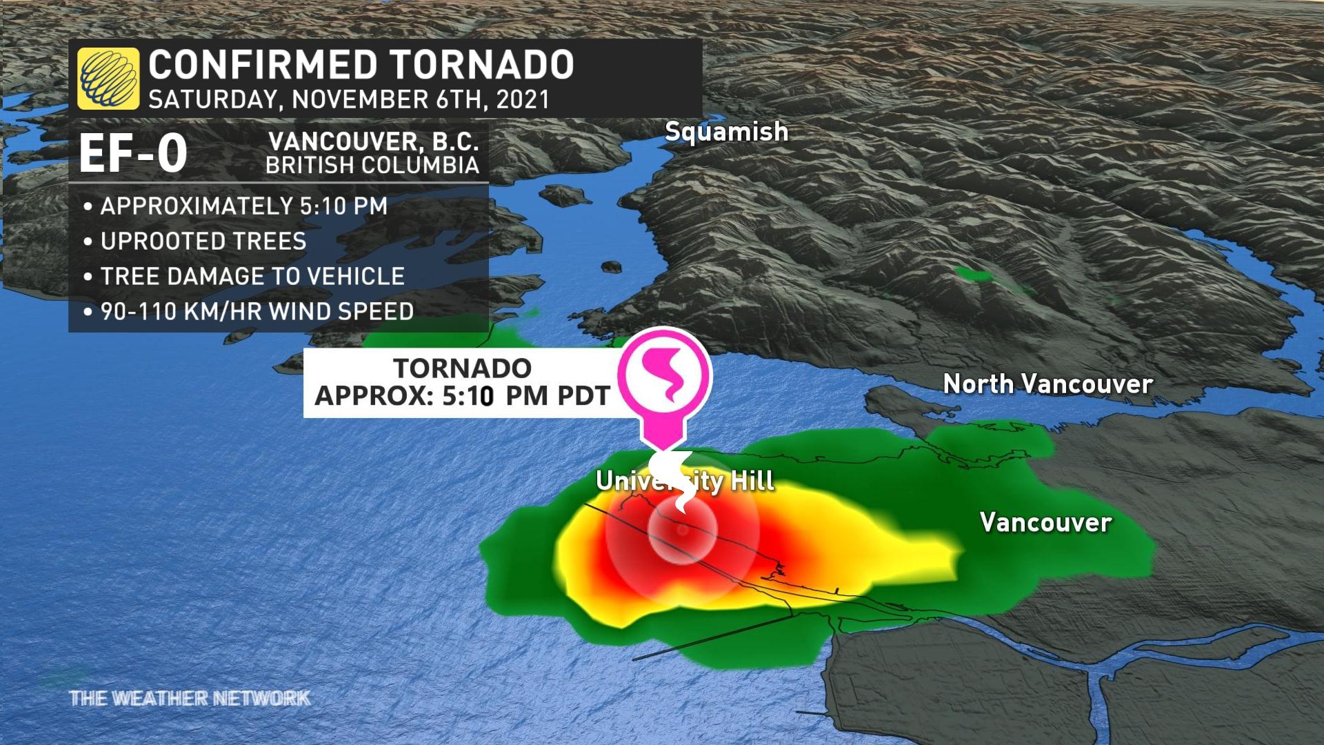
How Vancouver, B.C, pulled off the tornado upset of the century
Monday, November 8th 2021, 9:43 pm - If there's ever a tornado season in the Pacific Northwest, it's the fall where water temperatures are still relatively warm
A November tornado is extremely rare in Canada.
So it probably comes as a bit of a shock that it happened, but in the City of Vancouver? That's next-level rare, but I'll show you it certainly wasn't that far-fetched -- particularly with all of the convective ingredients available.
RELATED: 'Ultra-rare' November tornado hits Vancouver, B.C., damage reported
If there's ever a tornado season in the Pacific Northwest, it's the fall where water temperatures are still relatively warm. Add record-breaking Siberian air into the mix, and it's a recipe for an atmospheric mistake of epic proportions.
If you sampled the observations around 4 p.m. local time on Nov. 6, 2021 at Vancouver International Airport, the hour before tornado touchdown, you'd see a temperature reading of just 6°C. A temperature that doesn't support instability, although the dew point was 5°C.
That's important because the low-level environment was nearly saturated. If you'd raise a parcel of air, the packet of air would quickly condense and form clouds at the lifting condensation level; and that was just 500 metres or so over the surface of the Salish Sea.
Speaking of the water, this is where the low-level instability is enhanced -- in part because of the relatively warmer water temperatures. Buoys measured the water temperature at 10°C, which increased storm available energy.
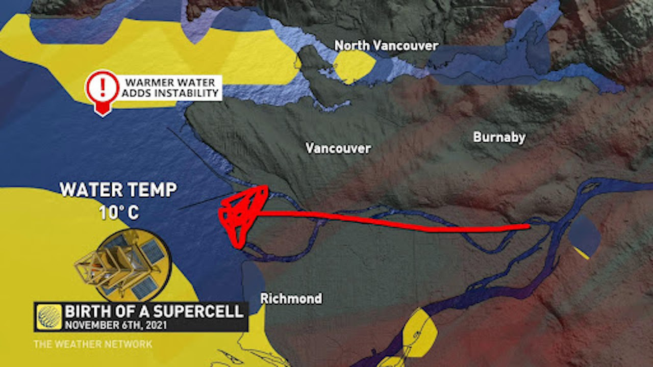
The final ingredient at the surface was a seemingly innocuous easterly wind. Models indicated a southerly wind would dominate the day, but that environment changed as an easterly wind blossomed. It increased the amount of directional shear, wind direction morphing with height, increasing the threat for rotating thunderstorms.
Still, even with these parameters in place, there wouldn't have been a tornado. We need to look up, way up, where the atmosphere was brewing something extreme.
A record-cold air mass engulfed much of the South Coast and the Pacific Northwest. At about 6 km aloft, the temperatures were below -30°C. It encourages parcels of air to continue to rise, but not necessarily rotate. That's where the pivotal trough comes into play, swinging in at the opportune time: Late afternoon.
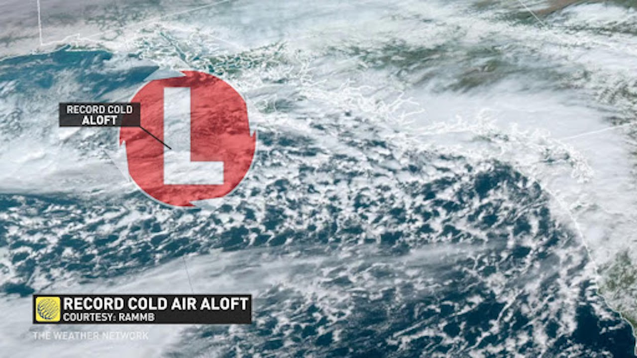
The winds associated with the trough were around 45 knots out of the southwest -- maximizing the amount of storm rotation in the atmosphere. Computer models underestimated this parameter.
The pockets of energy and lift in the trough were able to initiate convection.
SPIN WITHIN SPIN
The main low was well north of Vancouver Island. We'll call this the parent low, but a more insidious low was nestled in the Strait of Georgia, called a mesoscale low.
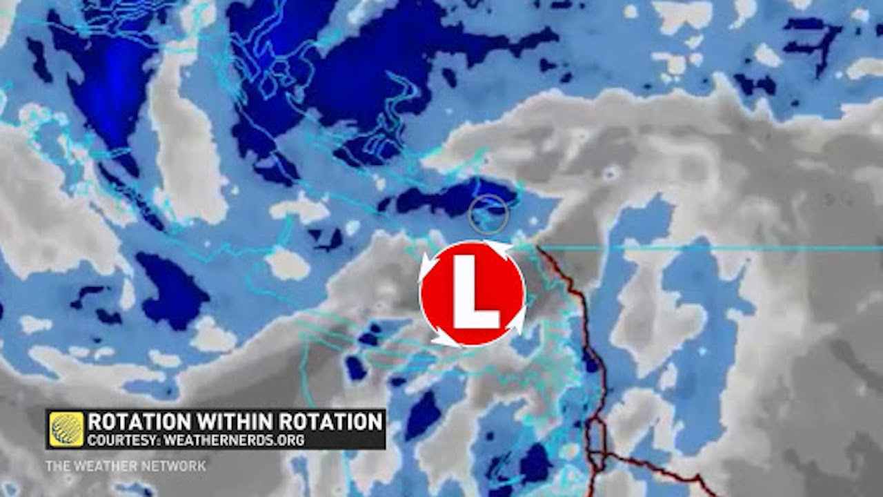
These lows are relatively common for the Georgia Strait and develop, in part, because of the topography in the area. There's evidence that the mountains and terrain can aid in storm rotation, as well. Air flows over mountainous terrain, leaving a pressure void at the surface; consequently, this enhances the available spin for a given storm.
It won't be the last tornado for the Lower Mainland, but it's a much more rare beast compared to the non-supercell waterspouts that can typically dance over the waters of the Georgia Strait.
Thumbnail courtesy of Shane Sidsworth/Submitted.
No comments:
Post a Comment