Record ocean heat, intensifying El Nino conditions and worsening extremes are raising the prospect that 2026 could become the hottest year ever measured.
Issued on: 08/08/2026 - RFI

Wildfires are burning across Europe and North America, successive heatwaves have baked major cities and the world’s oceans are warmer than ever recorded at this point in the year.
Yet despite the exceptional conditions, 2026 is not currently the planet's hottest year on record. So far, it ranks third behind 2024 and 2025.
That could change before December.
Scientists say the combination of accelerating human-driven climate change and an unusually powerful El Nino could push 2026 past 2024 – or at least bring it very close. Even if it falls short, experts predict that 2027 will likely to set a new global temperature record, potentially by a significant margin.
“The world is now on fire again with climate change in a way that’s increasingly difficult to ignore,” said Zeke Hausfather, a climate scientist at US-based research group Berkeley Earth. “It’s going to keep getting worse.”
Hausfather estimates there is now a 35 percent chance that 2026 will become the hottest year recorded, up from just 7 percent in March.
Early warning from oceans
One of the strongest indicators is the extraordinary warmth of the world’s oceans, which cover more than 70 percent of the planet.
Daily global sea surface temperatures matched 2024 levels in May and have remained at record highs on almost every day since June. Around 82 percent of the world’s ocean surface has experienced marine heatwave conditions this year, according to the European Union’s Copernicus Climate Change Service.
Changes in sea temperatures often take several weeks to appear in global atmospheric readings, says former senior Nasa climate scientist James Hansen, whose warnings about global warming stretch back four decades. He believes the trend indicates that this year will narrowly overtake 2024.

A powerful El Nino could make that even more likely. The natural phenomenon warms parts of the equatorial Pacific, raising average global temperatures and disrupting weather patterns around the world.
Forecasts suggest the developing El Nino could become the strongest ever measured.
El Nino releases heat that has built up in the oceans. But greenhouse gases have ensured there is now much more heat available to release, with the seas absorbing about 90 percent of the excess warmth trapped by emissions.
Scientists stress, however, that El Nino cannot explain the wildfires and extreme temperatures already seen this summer, as its strongest effects are not expected until later in the year.
“The driver of the record warmth is climate change in the background,” said Zachary Labe, a climate scientist at Climate Central, a science and communications nonprofit. El Nino, he added, would contribute only around one or two tenths of a degree on top of the longer-term warming trend.
Europe has been among the regions most visibly affected this year.
The continent experienced what Copernicus described as an exceptional heatwave in May, followed by another in June, two more in July, and further extreme temperatures across France and Spain in early August.
“What is very unusual for Europe for this particular year is the frequency and extent of the heatwaves,” said Samantha Burgess, Copernicus’s global strategic lead.
In Europe, repeated periods of intense heat can be particularly dangerous because many homes and cities were not designed for prolonged high temperatures. This year's heatwaves have been especially noticeable at night, said Burgess, which disrupts sleep and increases health risks.

Extreme heat has also struck North and South America and India, while wildfires have burned across several regions.
For Princeton University climate scientist Michael Oppenheimer, this summer’s fires and heatwaves represent what experts have been warning the world faces.
“These are vivid pictures of not just the future, which is what we used to say, but on the whole of what climate change is doing,” he said.
“There’s no question that climate change has increased the risk of wildfires. There’s no question that the climate change increased the probability of really hot, nasty, even unprecedented summers around the world.”
(with AP)
Panama Canal Cuts Draft for Largest Ships as El Niño Intensifies
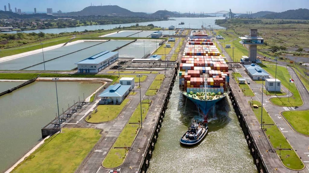
The Panama Canal Authority reported that it is lowering the maximum draft for the largest vessels transiting the canal as it works to stay ahead of the intensifying El Niño weather pattern. The move comes as both the US’s National Oceanic and Atmospheric Administration (NOAA) and the World Meteorological Organization have each warned that the current weather pattern is expected to intensify to record levels.
The latest round of restrictions at the Panama Canal is focused on the Neopanamax locks, which are the newer locks created to handle the largest vessels. As such, it will impact containerships as well as the laden LNG carriers and tankers. During the 2023-2024 drought and water restrictions, the authority also imposed restrictions at the locks, which forced many of these vessels to limit their cargoes, or in the case of containerships, they transshipped portions of the load across the isthmus by train.
Effective on August 26, the Panama Canal Authority is lowering the maximum draft for the Neopanamax locks to 48 feet (14.63 meters). A further adjustment is planned for September 3, lowering the maximum draft to 47.5 feet (14.48 meters).
“The measure is based on current water levels and projected conditions for the upcoming weeks in Gatun Lake,” said the authority. It said it is part of its ongoing water management and operational strategy and benefits from the lessons learned during the 2023-2024 period.
NOAA reported in June that the phenomenon was beginning to form. Forecasters predicted a 63 percent chance of sea surface temperatures exceeding 2.0 degrees C in the Niño-monitored region of the Pacific, which they said would be considered a “very strong” El Niño. NOAA reiterated its forecasts on August 6 for the North Atlantic hurricane season, with the only good news that the strong El Niño is likely to result in a 75 percent chance of below-normal hurricane activity, NOAA forecasters predicted.
However, it is also likely to cause significantly lower rainfall in areas, including the Caribbean and Latin America. The Panama Canal Authority reports that currently the water level in Gatun Lake, which supplies the canal, is at just over 84 feet, down nearly a foot since July. Its forecast further expects the lake to fall to approximately 83 feet by September.
Gatun Lake’s lowest five-year average water level was just under 84 feet in May. However, in 2023, during the last significant drought, starting in June and through until October, the lake was measured at just over 79 feet as the authority imposed limits on the number of vessels and their drafts.
The canal authority confirmed that the new steps are the fourth and fifth draft adjustments this year, after it lowered the levels for the Neopanamax locks to 49 feet and then 48.5 feet in July. During the 2023-2024 drought, the levels were cut as low as 43.5 feet.
Critically, it emphasizes that currently, it has not changed the number of daily transits. However, as of late July, it suspended the auction for close-in transit slots. In 2023, the canal cut the number of slots to as low as 22 transits per day from the normal of up to 38 a day.
The concern is that the canal is already seeing increased traffic as U.S. energy exports to Asia rose in response to the closure of the Strait of Hormuz. At the same time, U.S. imports have remained strong. Currently, the canal’s online dashboard shows a total of 70 booked vessels and 35 non-booked vessels waiting for transit, and the average waiting time is increasing. The average is now over six days in both directions, with Neopanamax vessels waiting between two and 11 days. There are currently 15 booked Neopanamax vessels waiting for transit and another 11 without reservations.

No comments:
Post a Comment