
Photo Credit: Gadfium, Wikipedia Commons
June 2, 2026
By Indo-Pacific Defense Forum
China’s posture in the Indo-Pacific includes the deployment of research vessels under civilian guise but designed for military exploitation. Increasingly, these vessels collect marine data in the region’s disputed waters. Although Beijing calls the survey trips scientific research, the excursions often mask intelligence gathering of military value — particularly near the United States territory of Guam, the Philippines and self-governed Taiwan.
Understanding this dual-use phenomenon is crucial for anticipating operational challenges, advising policy, and supporting deterrence and resilience for the U.S. and its Allies and Partners. This is true especially for those along the so-called first island chain, a string of major Pacific archipelagos that runs from Japan south through Taiwan, the Philippines and on to Borneo, forming a strategic barrier off China’s mainland. China, however, also increasingly collects extensive data farther from its shores, stretching from the Indian Ocean to the South Pacific.
“In truth, all maritime data collection is dual use — it could have useful oceanographic, climate, scientific uses; but it can also have military uses. I’m overall suspicious about China’s intent in the region,” Bruce Jones, a senior fellow at the Washington, D.C.-based Brookings Institution, told FORUM. He is studying China’s ocean research effort.
China operates one of the world’s largest fleets of civilian oceanographic research vessels, analysts say. The Center for Strategic and International Studies (CSIS) reported in 2024 that “of the 64 active vessels, over 80% have demonstrated suspect behavior or possess organizational links suggesting their involvement in advancing Beijing’s geopolitical agenda,” indicating dual-use capabilities at scale.
The strategic opaqueness of China’s research ship operations challenges monitoring, complicates defensive postures and advances excessive maritime claims, analysts say. The vessels frequently operate in contested waters, gathering data on bathymetry (water depth), seafloor structure and oceanographic conditions — information that the People’s Liberation Army (PLA) can leverage for submarine operations, amphibious planning, and mine and antisurface warfare.
In November 2025, for instance, China deployed three dual-use research vessels in the Indian Ocean. India’s maritime surveillance agencies monitored the ships, which included the Shi Yan 6, Shen Hai Yi Hao and Lan Hai 201. “Such deployments typically prompt diplomatic caution and potential denial of port calls at Indian facilities, as seen in earlier instances involving similar Chinese missions,” Indian Defence News reported. The Indian Coast Guard and Navy reported the constant presence of Chinese research vessels in recent years near India’s waters.
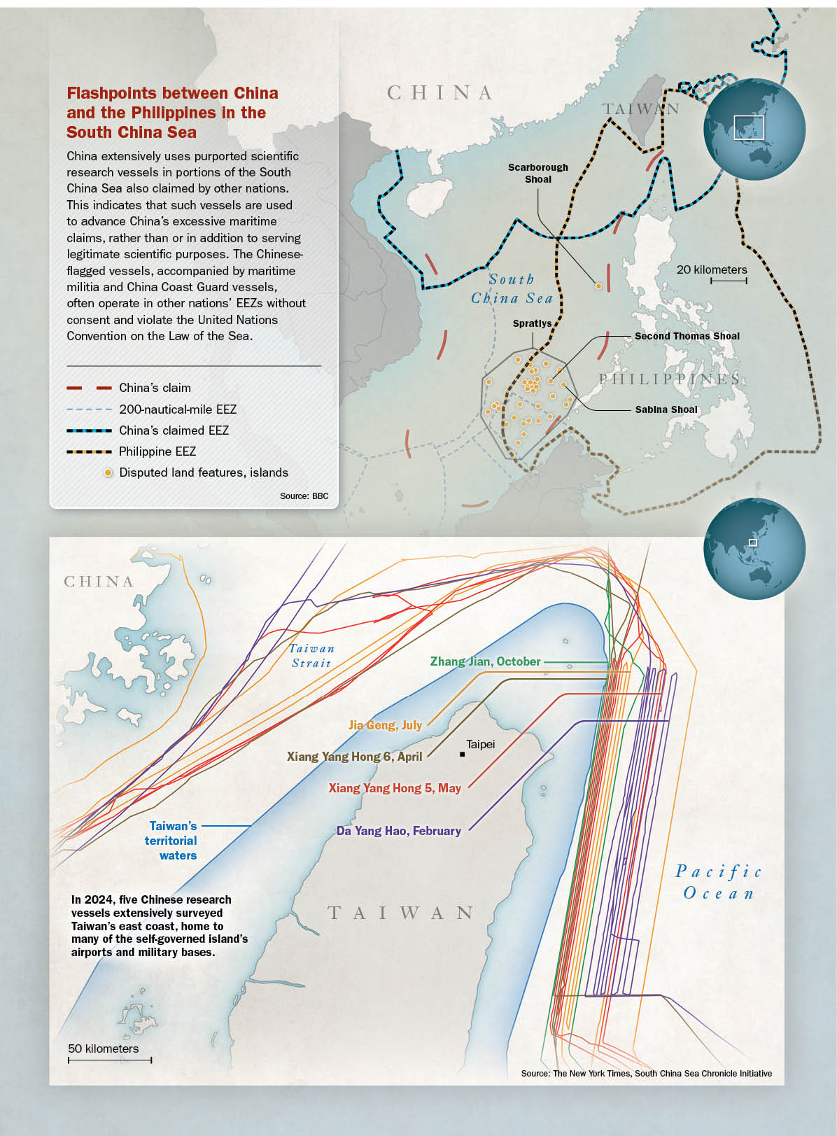
The Haiyang Dizhi 8, as another example, conducted oil and gas surveys off Vietnam’s coast for four months without authorization, highlighting how the vessels can penetrate contested maritime zones under the cover of scientific legitimacy, according to the CSIS’s Asia Maritime Transparency Initiative. The Xiang Yang Hong 6 also exemplifies China’s dual purposes. The vessel and five others made 25 passes in parallel lines off Taiwan’s east coast in 2024, conducting systematic seabed surveys, according to Starboard Maritime Intelligence data cited by The New York Times newspaper in July 2025.
“It’s hard for us to view this situation as normal,” Kuan Bi-ling, the minister of Taiwan’s Ocean Affairs Council, told The New York Times.
The same ships have been active around Guam — home to vital U.S. military installations — collecting data relevant to submarine operations. “It appears that China is trying to collect bathymetric data on that part of the ocean without appearing like it is conducting a bathymetric survey,” Ryan D. Martinson, an assistant professor and expert on Chinese research ships at the U.S. Naval War College, told the newspaper.
Such activities are emblematic of China’s gray-zone tactics, coercive state actions that fall short of open warfare. China views such activity as “a natural extension of how countries exercise power [to] pressure countries to act according to Beijing’s interests [and] without triggering backlash or conflict,” according to a 2022 Rand Corp. report, “A New Framework for Understanding and Countering China’s Gray Zone Tactics.”
Similarly, a June 2023 article published by the SeaLight research initiative noted that “China’s deployment of research and survey vessels in contested waters is a key component of its maritime gray-zone strategy. These vessels, often presented as civilian or scientific, are frequently state-owned or operated by entities with close military ties.” For example, the Chinese Academy of Sciences and China’s Natural Resources Ministry operate research vessels and have PLA cooperation agreements, CSIS reported. The U.S.-based SeaLight uses commercially available technology to expose maritime gray-zone activities.
China has increased marine data collection throughout key Indo-Pacific waters, sometimes disregarding international law that requires coastal state consent for research inside that nation’s exclusive economic zone (EEZ), the U.S. Indo-Pacific Command (USINDOPACOM) reported in July 2025. This pattern reflects a wider lawfare campaign designed to normalize excessive maritime claims while undermining the sovereign rights of coastal states, the report said.
“There are both legal and illegal and aggressive/nonaggressive ways to enter other countries’ EEZs. China is doing a lot of all of the above,” Jones said. “Their behavior is aggressive because it’s aggressive, not because it is/isn’t a violation of the law of the sea.”
South China Sea Surveillance
China’s survey vessels, operating within the EEZs of nations such as the Philippines, obtain maritime domain awareness in contested areas. They reinforce Beijing’s ability to map and exploit the seabed, with implications for mining, anti-submarine warfare and undersea infrastructure monitoring, among other ventures.
Moreover, these activities are part of a convergence of maritime coercion. China’s gray-zone campaigns often establish localized “advantages [for China] that can be sustained over time without precipitating acute crisis,” Isaac Kardon, a senior fellow at the Carnegie Endowment’s Asia Program, testified in June 2024 before the U.S. Congress.
This sustained presence in waters near the Philippines, Taiwan and other areas seeks to normalize China’s maritime coercion and erode the strategic threshold for escalation. “If you look at China’s coast guard and its maritime militia over the last three years — you would see a dramatic increase in the number of ships and the depth of the penetration,” SeaLight Director Ray Powell told The Wall Street Journal newspaper in March 2025. “It’s taken on the character of a maritime occupation.”
For example, China’s ships have made multiple incursions at the contested Sabina Shoal within Manila’s EEZ. In April 2024, the Philippines raised its flag at the shoal to assert sovereignty, prompting China’s deployment of a massive 12,000-ton Coast Guard vessel. Such events typify the pattern: China’s civilian or paramilitary-type vessels enter other nations’ claimed waters to consolidate their presence, gather environmental or hydrographic data, or prepare a pretext for sustained operations.
In May 2025, the Philippines deployed a Coast Guard vessel and aircraft to track a Chinese research ship operating illegally in its EEZ. Manila declared China’s activity a sovereignty violation. The incident reflects China’s strategy of ignoring its obligations as a signatory to the United Nations Convention on the Law of the Sea while pressing its arbitrary and excessive claims.
By pairing scientific vessels with China Coast Guard and maritime militia escorts, Beijing multiplies the coercive effect. The actions show the PLA’s growing use of undersea terrain data to support operations that threaten a free, secure and prosperous Indo-Pacific, analysts say.
China’s alarming gray-zone maritime strategy leverages civilian, paramilitary and military assets, including research and fishing vessels, to exert control over contested zones. This multilayered coercion erodes norms and reinforces China’s maritime claims incrementally. Such operations allow the Chinese Communist Party (CCP) to coerce “while avoiding a conventional military response from the United States and its allies,” notes the November 2024 Rand Corp. report “Understanding and Countering China’s Maritime Gray Zone Operations.” The report recommends enhanced presence, transparency initiatives and allied coordination as deterrent measures.
Masked Intent Near Taiwan
The Taiwan Strait and its eastern approaches are at the heart of China’s coercion campaign. China’s parallel survey patterns east of Taiwan suggest mapping for submarine deployment or interdiction zones. Equally concerning are China’s surveys near Guam — a hub for U.S. power projection in the Western Pacific. Chinese research vessels resumed operations east of Guam as recently as June 2025, according to data cited by The New York Times.
Taiwan’s military intelligence noted a dramatic uptick in China’s maritime and aerial activity across the Indo-Pacific in 2024: nearly 12,000 flights and more than 86,000 missions at sea — military exercises that totaled an estimated $21 billion in operational costs and a nearly 40% increase over 2023 spending, the Reuters news service reported.
Such overt actions distract from less-visible activities such as marine data collection, which accumulates military advantage without risking immediate escalation. The extent of the drills underscores the potential scale and normalization of PLA maritime activities — an environment in which research ships can mix, gather environmental and electromagnetic data, and facilitate PLA submarine or amphibious operations near Taiwan under technical pretexts. “They are trying to normalize their military power projection and intimidation around the first island chain,” a Taiwan military official told Reuters.
Legal Double Standards
China’s marine data collection is a tool for “preparing the battlespace,” particularly when survey tracks are along likely submarine routes or amphibious approach corridors, according to USINDOPACOM. China is moving toward a more conventional approach, indicating a rising threshold of risk tolerance, including in the Pacific, The Heritage Foundation reported in September 2024. Further, PLA modernization is sharpening strategic pressures, making encounters — including those involving ostensibly benign vessels — more fraught and dangerous, according to a May 2024 report by the U.S.-based National Bureau of Asian Research.
China’s rapid expansion and deployment of its research and survey fleet, and the systematic surveys it conducts near Guam, the Philippines and Taiwan, are not merely to advance science. They signal and enable coercion and are part of a strategy to collect data of military utility, normalize excessive claims and undermine the sovereign rights of Indo-Pacific states. Vessels such as the Xiang Yang Hong 6 embody this duality — flying the flag of science but sailing as military scouts. Their data collection should be understood for what it is, analysts say: a gray-zone operation, reinforced by lawfare, to ready the battlespace for potential conflict.
Strengthening Countermeasures
To ensure a free, secure and prosperous Indo-Pacific, the U.S. and its Allies and Partners must remain vigilant about China’s maritime activities — exposing Beijing’s duplicity and countering its attempts to redraw the physical and legal maps that define the maritime domain.
Regional resilience requires recognition of this threat and promotion of cooperative mechanisms to challenge China’s opaqueness and normalization of dual-use maritime activity, defense experts say.
“The U.S. is the most important oceanographic power in the world — but China is catching up and several of our Allies and Partners have very important capacity, skills, local knowledge and geography,” said Jones, the Brookings senior fellow. Countermeasures should integrate intelligence, law enforcement and economic tracking mechanisms, according to Benjamin Jensen, director of CSIS’s Futures Lab, and his colleagues. In commentary published on the CSIS website, they recommended interagency campaigns to counter China’s gray-zone incursions. A joint interagency task force or similar entity could integrate mechanisms to identify CCP influence channels in real time, they wrote.
“The goal isn’t just to shut down documented incursions — it’s to shape the environment so that China loses its ability to leverage migration, illicit finance, and cyber operations as tools of competition,” the CSIS team wrote. That means “deploying targeted counterintelligence and economic measures across the Pacific. It means leveraging the [U.S.] Department of the Treasury’s tools to disrupt illicit Chinese financial networks. It means expanding the use of contracted intelligence, surveillance, and reconnaissance assets to avoid straining existing military collection capabilities. And it means crafting an influence campaign to expose and undermine CCP operations in the information space before they gain traction.”
They cited Jade Spear, an interagency initiative that targeted illegal, unreported and unregulated fishing by China’s fleet. The operation coordinated 15 U.S. agencies to target labor violations and human trafficking, impose sanctions, revoke visas and licenses, inspect vessels, and investigate fishing companies. “Jade Spear [reimagined] the spectrum of engagement with the CCP — it’s not just about use of kinetic action, but the entire arsenal of U.S. bureaucracy can be called to action,” they wrote.
“The private sector plays a critical role —
financial institutions, tech companies and media platforms must be mobilized to prevent CCP actors from exploiting digital spaces and economic systems.”
The U.S. and its Allies and Partners require a sustained, proactive approach to prevent China from exploiting gaps in governance, security and perception management, they concluded. “The real shift must come from embracing competition as a continuous condition, not a crisis-driven response. … It’s not just about blocking Chinese influence — it’s about making the Indo-Pacific a space where U.S. alliances, institutions, and economic frameworks make CCP subversion infeasible.”
China is Mapping the Region’s Seabed for Geopolitical, Military Advantage
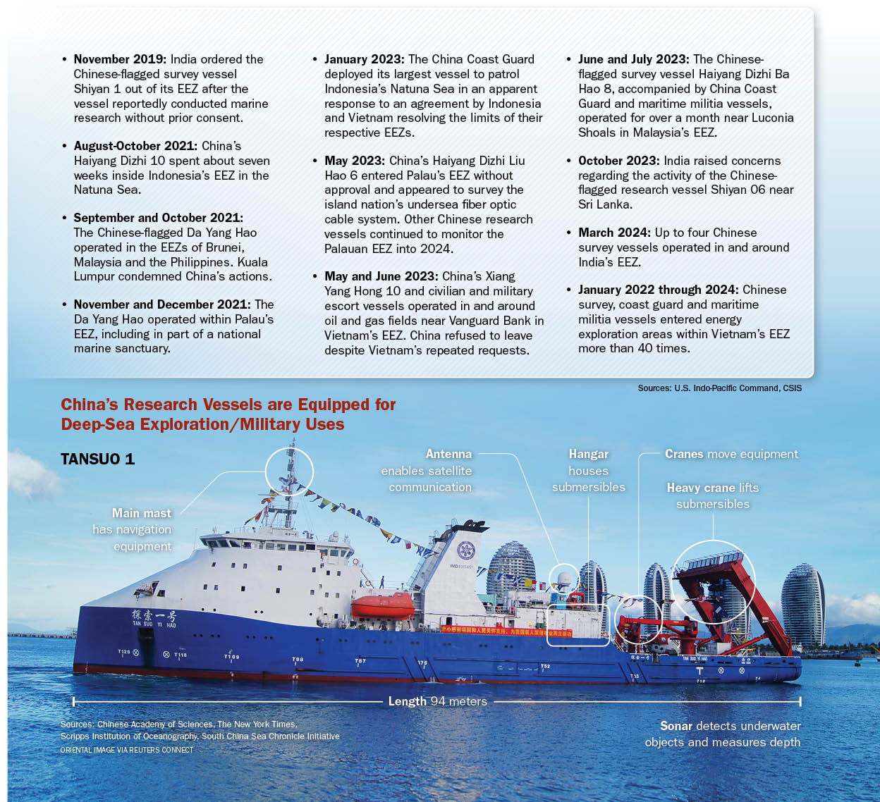
Chinese-flagged survey vessels are collecting marine data on an unprecedented scale. Between 2020 and 2024, 64 vessels engaged in hundreds of thousands of hours of operations worldwide, with more than 80% exhibiting dual-use behavior or ties to China’s geopolitical agenda, according to the Center for Strategic and International Studies (CSIS), a U.S.-based think tank.
China also has deployed research vessels to strengthen its presence in geopolitical hotspots. Commercial and scientific research ships, such as those operated by the state-owned China Oilfield Services Ltd., have helped the Chinese Communist Party assert its illegal claims of sovereignty over large swaths of the South China Sea and obstruct coastal states from finding and extracting natural resources, a study by CSIS found.
Chinese ships have conducted survey operations within the exclusive economic zones (EEZ) of other countries without prior approval, which is prohibited under international law. This also constitutes a double standard given China heavily restricts foreign activities in its EEZ.
China appears to use marine data to bolster its excessive claims and prevent other states from exercising their sovereign rights.
Deterrence Measures
To counter China’s maritime gray-zone activities, Allies and Partners should focus on:Transparency: Enhance intelligence sharing and public transparency on research ship movements, flagging dual-use indicators.
Policy coordination: Support interagency initiatives that combine maritime enforcement, sanctions, licensing and public-private cooperation.
Capacity building: Strengthen regional domain awareness via cooperative deployments, hydrographic surveys and shared sensor networks.
Legal frameworks: Clarify norms regarding scientific vessel activity in nations’ EEZs and clearly define boundaries for data collection.
Strategic messaging: Identify China’s dual-use research vessel surveys as part of its coercive strategy.
June 2, 2026
By Indo-Pacific Defense Forum
China’s posture in the Indo-Pacific includes the deployment of research vessels under civilian guise but designed for military exploitation. Increasingly, these vessels collect marine data in the region’s disputed waters. Although Beijing calls the survey trips scientific research, the excursions often mask intelligence gathering of military value — particularly near the United States territory of Guam, the Philippines and self-governed Taiwan.
Understanding this dual-use phenomenon is crucial for anticipating operational challenges, advising policy, and supporting deterrence and resilience for the U.S. and its Allies and Partners. This is true especially for those along the so-called first island chain, a string of major Pacific archipelagos that runs from Japan south through Taiwan, the Philippines and on to Borneo, forming a strategic barrier off China’s mainland. China, however, also increasingly collects extensive data farther from its shores, stretching from the Indian Ocean to the South Pacific.
“In truth, all maritime data collection is dual use — it could have useful oceanographic, climate, scientific uses; but it can also have military uses. I’m overall suspicious about China’s intent in the region,” Bruce Jones, a senior fellow at the Washington, D.C.-based Brookings Institution, told FORUM. He is studying China’s ocean research effort.
China operates one of the world’s largest fleets of civilian oceanographic research vessels, analysts say. The Center for Strategic and International Studies (CSIS) reported in 2024 that “of the 64 active vessels, over 80% have demonstrated suspect behavior or possess organizational links suggesting their involvement in advancing Beijing’s geopolitical agenda,” indicating dual-use capabilities at scale.
The strategic opaqueness of China’s research ship operations challenges monitoring, complicates defensive postures and advances excessive maritime claims, analysts say. The vessels frequently operate in contested waters, gathering data on bathymetry (water depth), seafloor structure and oceanographic conditions — information that the People’s Liberation Army (PLA) can leverage for submarine operations, amphibious planning, and mine and antisurface warfare.
In November 2025, for instance, China deployed three dual-use research vessels in the Indian Ocean. India’s maritime surveillance agencies monitored the ships, which included the Shi Yan 6, Shen Hai Yi Hao and Lan Hai 201. “Such deployments typically prompt diplomatic caution and potential denial of port calls at Indian facilities, as seen in earlier instances involving similar Chinese missions,” Indian Defence News reported. The Indian Coast Guard and Navy reported the constant presence of Chinese research vessels in recent years near India’s waters.
The Haiyang Dizhi 8, as another example, conducted oil and gas surveys off Vietnam’s coast for four months without authorization, highlighting how the vessels can penetrate contested maritime zones under the cover of scientific legitimacy, according to the CSIS’s Asia Maritime Transparency Initiative. The Xiang Yang Hong 6 also exemplifies China’s dual purposes. The vessel and five others made 25 passes in parallel lines off Taiwan’s east coast in 2024, conducting systematic seabed surveys, according to Starboard Maritime Intelligence data cited by The New York Times newspaper in July 2025.
“It’s hard for us to view this situation as normal,” Kuan Bi-ling, the minister of Taiwan’s Ocean Affairs Council, told The New York Times.
The same ships have been active around Guam — home to vital U.S. military installations — collecting data relevant to submarine operations. “It appears that China is trying to collect bathymetric data on that part of the ocean without appearing like it is conducting a bathymetric survey,” Ryan D. Martinson, an assistant professor and expert on Chinese research ships at the U.S. Naval War College, told the newspaper.
Such activities are emblematic of China’s gray-zone tactics, coercive state actions that fall short of open warfare. China views such activity as “a natural extension of how countries exercise power [to] pressure countries to act according to Beijing’s interests [and] without triggering backlash or conflict,” according to a 2022 Rand Corp. report, “A New Framework for Understanding and Countering China’s Gray Zone Tactics.”
Similarly, a June 2023 article published by the SeaLight research initiative noted that “China’s deployment of research and survey vessels in contested waters is a key component of its maritime gray-zone strategy. These vessels, often presented as civilian or scientific, are frequently state-owned or operated by entities with close military ties.” For example, the Chinese Academy of Sciences and China’s Natural Resources Ministry operate research vessels and have PLA cooperation agreements, CSIS reported. The U.S.-based SeaLight uses commercially available technology to expose maritime gray-zone activities.
China has increased marine data collection throughout key Indo-Pacific waters, sometimes disregarding international law that requires coastal state consent for research inside that nation’s exclusive economic zone (EEZ), the U.S. Indo-Pacific Command (USINDOPACOM) reported in July 2025. This pattern reflects a wider lawfare campaign designed to normalize excessive maritime claims while undermining the sovereign rights of coastal states, the report said.
“There are both legal and illegal and aggressive/nonaggressive ways to enter other countries’ EEZs. China is doing a lot of all of the above,” Jones said. “Their behavior is aggressive because it’s aggressive, not because it is/isn’t a violation of the law of the sea.”
South China Sea Surveillance
China’s survey vessels, operating within the EEZs of nations such as the Philippines, obtain maritime domain awareness in contested areas. They reinforce Beijing’s ability to map and exploit the seabed, with implications for mining, anti-submarine warfare and undersea infrastructure monitoring, among other ventures.
Moreover, these activities are part of a convergence of maritime coercion. China’s gray-zone campaigns often establish localized “advantages [for China] that can be sustained over time without precipitating acute crisis,” Isaac Kardon, a senior fellow at the Carnegie Endowment’s Asia Program, testified in June 2024 before the U.S. Congress.
This sustained presence in waters near the Philippines, Taiwan and other areas seeks to normalize China’s maritime coercion and erode the strategic threshold for escalation. “If you look at China’s coast guard and its maritime militia over the last three years — you would see a dramatic increase in the number of ships and the depth of the penetration,” SeaLight Director Ray Powell told The Wall Street Journal newspaper in March 2025. “It’s taken on the character of a maritime occupation.”
For example, China’s ships have made multiple incursions at the contested Sabina Shoal within Manila’s EEZ. In April 2024, the Philippines raised its flag at the shoal to assert sovereignty, prompting China’s deployment of a massive 12,000-ton Coast Guard vessel. Such events typify the pattern: China’s civilian or paramilitary-type vessels enter other nations’ claimed waters to consolidate their presence, gather environmental or hydrographic data, or prepare a pretext for sustained operations.
In May 2025, the Philippines deployed a Coast Guard vessel and aircraft to track a Chinese research ship operating illegally in its EEZ. Manila declared China’s activity a sovereignty violation. The incident reflects China’s strategy of ignoring its obligations as a signatory to the United Nations Convention on the Law of the Sea while pressing its arbitrary and excessive claims.
By pairing scientific vessels with China Coast Guard and maritime militia escorts, Beijing multiplies the coercive effect. The actions show the PLA’s growing use of undersea terrain data to support operations that threaten a free, secure and prosperous Indo-Pacific, analysts say.
China’s alarming gray-zone maritime strategy leverages civilian, paramilitary and military assets, including research and fishing vessels, to exert control over contested zones. This multilayered coercion erodes norms and reinforces China’s maritime claims incrementally. Such operations allow the Chinese Communist Party (CCP) to coerce “while avoiding a conventional military response from the United States and its allies,” notes the November 2024 Rand Corp. report “Understanding and Countering China’s Maritime Gray Zone Operations.” The report recommends enhanced presence, transparency initiatives and allied coordination as deterrent measures.
Masked Intent Near Taiwan
The Taiwan Strait and its eastern approaches are at the heart of China’s coercion campaign. China’s parallel survey patterns east of Taiwan suggest mapping for submarine deployment or interdiction zones. Equally concerning are China’s surveys near Guam — a hub for U.S. power projection in the Western Pacific. Chinese research vessels resumed operations east of Guam as recently as June 2025, according to data cited by The New York Times.
Taiwan’s military intelligence noted a dramatic uptick in China’s maritime and aerial activity across the Indo-Pacific in 2024: nearly 12,000 flights and more than 86,000 missions at sea — military exercises that totaled an estimated $21 billion in operational costs and a nearly 40% increase over 2023 spending, the Reuters news service reported.
Such overt actions distract from less-visible activities such as marine data collection, which accumulates military advantage without risking immediate escalation. The extent of the drills underscores the potential scale and normalization of PLA maritime activities — an environment in which research ships can mix, gather environmental and electromagnetic data, and facilitate PLA submarine or amphibious operations near Taiwan under technical pretexts. “They are trying to normalize their military power projection and intimidation around the first island chain,” a Taiwan military official told Reuters.
Legal Double Standards
China’s marine data collection is a tool for “preparing the battlespace,” particularly when survey tracks are along likely submarine routes or amphibious approach corridors, according to USINDOPACOM. China is moving toward a more conventional approach, indicating a rising threshold of risk tolerance, including in the Pacific, The Heritage Foundation reported in September 2024. Further, PLA modernization is sharpening strategic pressures, making encounters — including those involving ostensibly benign vessels — more fraught and dangerous, according to a May 2024 report by the U.S.-based National Bureau of Asian Research.
China’s rapid expansion and deployment of its research and survey fleet, and the systematic surveys it conducts near Guam, the Philippines and Taiwan, are not merely to advance science. They signal and enable coercion and are part of a strategy to collect data of military utility, normalize excessive claims and undermine the sovereign rights of Indo-Pacific states. Vessels such as the Xiang Yang Hong 6 embody this duality — flying the flag of science but sailing as military scouts. Their data collection should be understood for what it is, analysts say: a gray-zone operation, reinforced by lawfare, to ready the battlespace for potential conflict.
Strengthening Countermeasures
To ensure a free, secure and prosperous Indo-Pacific, the U.S. and its Allies and Partners must remain vigilant about China’s maritime activities — exposing Beijing’s duplicity and countering its attempts to redraw the physical and legal maps that define the maritime domain.
Regional resilience requires recognition of this threat and promotion of cooperative mechanisms to challenge China’s opaqueness and normalization of dual-use maritime activity, defense experts say.
“The U.S. is the most important oceanographic power in the world — but China is catching up and several of our Allies and Partners have very important capacity, skills, local knowledge and geography,” said Jones, the Brookings senior fellow. Countermeasures should integrate intelligence, law enforcement and economic tracking mechanisms, according to Benjamin Jensen, director of CSIS’s Futures Lab, and his colleagues. In commentary published on the CSIS website, they recommended interagency campaigns to counter China’s gray-zone incursions. A joint interagency task force or similar entity could integrate mechanisms to identify CCP influence channels in real time, they wrote.
“The goal isn’t just to shut down documented incursions — it’s to shape the environment so that China loses its ability to leverage migration, illicit finance, and cyber operations as tools of competition,” the CSIS team wrote. That means “deploying targeted counterintelligence and economic measures across the Pacific. It means leveraging the [U.S.] Department of the Treasury’s tools to disrupt illicit Chinese financial networks. It means expanding the use of contracted intelligence, surveillance, and reconnaissance assets to avoid straining existing military collection capabilities. And it means crafting an influence campaign to expose and undermine CCP operations in the information space before they gain traction.”
They cited Jade Spear, an interagency initiative that targeted illegal, unreported and unregulated fishing by China’s fleet. The operation coordinated 15 U.S. agencies to target labor violations and human trafficking, impose sanctions, revoke visas and licenses, inspect vessels, and investigate fishing companies. “Jade Spear [reimagined] the spectrum of engagement with the CCP — it’s not just about use of kinetic action, but the entire arsenal of U.S. bureaucracy can be called to action,” they wrote.
“The private sector plays a critical role —
financial institutions, tech companies and media platforms must be mobilized to prevent CCP actors from exploiting digital spaces and economic systems.”
The U.S. and its Allies and Partners require a sustained, proactive approach to prevent China from exploiting gaps in governance, security and perception management, they concluded. “The real shift must come from embracing competition as a continuous condition, not a crisis-driven response. … It’s not just about blocking Chinese influence — it’s about making the Indo-Pacific a space where U.S. alliances, institutions, and economic frameworks make CCP subversion infeasible.”
China is Mapping the Region’s Seabed for Geopolitical, Military Advantage
Chinese-flagged survey vessels are collecting marine data on an unprecedented scale. Between 2020 and 2024, 64 vessels engaged in hundreds of thousands of hours of operations worldwide, with more than 80% exhibiting dual-use behavior or ties to China’s geopolitical agenda, according to the Center for Strategic and International Studies (CSIS), a U.S.-based think tank.
China also has deployed research vessels to strengthen its presence in geopolitical hotspots. Commercial and scientific research ships, such as those operated by the state-owned China Oilfield Services Ltd., have helped the Chinese Communist Party assert its illegal claims of sovereignty over large swaths of the South China Sea and obstruct coastal states from finding and extracting natural resources, a study by CSIS found.
Chinese ships have conducted survey operations within the exclusive economic zones (EEZ) of other countries without prior approval, which is prohibited under international law. This also constitutes a double standard given China heavily restricts foreign activities in its EEZ.
China appears to use marine data to bolster its excessive claims and prevent other states from exercising their sovereign rights.
Concealed Mission
China’s dual-use research fleet offers strategic advantages for potential military operations:Environmental intelligence: Hydrographic and oceanographic data supports planning for submarine routing, mine deployment, undersea sensor placement and amphibious landing.
Sensor development: Data on sound propagation and currents aid in passive acoustic detection and sensor optimization.
Access creep: Regular presence of civilian vessels normalizes operations inside a nation’s exclusive economic zone (EEZ), making detection and interdiction politically complex.
Infrastructure placement: Data can support undersea infrastructure such as communication cables, sensors and uncrewed vehicles.
Deterrence Measures
To counter China’s maritime gray-zone activities, Allies and Partners should focus on:Transparency: Enhance intelligence sharing and public transparency on research ship movements, flagging dual-use indicators.
Policy coordination: Support interagency initiatives that combine maritime enforcement, sanctions, licensing and public-private cooperation.
Capacity building: Strengthen regional domain awareness via cooperative deployments, hydrographic surveys and shared sensor networks.
Legal frameworks: Clarify norms regarding scientific vessel activity in nations’ EEZs and clearly define boundaries for data collection.
Strategic messaging: Identify China’s dual-use research vessel surveys as part of its coercive strategy.
Sources: Center for Strategic and International Studies, Daniel K. Inouye Asia-Pacific Center for Security Studies, Heritage Foundation, Rand Corp.
This article was published by Indo-Pacific Defense FORUM
No comments:
Post a Comment