Hurricane Beryl Turns Towards Texas Coast

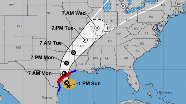
Hurricane Beryl strengthened to hurricane force for a second time before making its third landfall in Texas. The storm's predicted track has shifted to the north since last week, and it is now expected to arrive on Texas' central coast early Monday.
Beryl was the earliest-formed Category 5 hurricane on record when it first picked up speed on July 1, and it was just the second storm ever to reach this intensity before August. As it gained strength and passed through the southeastern Caribbean, it killed at least three in Grenada, one in St. Vincent and the Grenadines, and two in Venezuela. Grenada's outlying island of Carriacou was particularly hard-hit. It then brushed past the southern coast of Jamaica and lost steam before making landfall a second time in the Yucatan as a tropical storm. It arrived near the resort city of Tulum, but its wind speed had dropped to just 55 knots and it did little damage. The storm crossed over the Yucatan without causing any fatalities, and it moved seaward again over the southern Gulf of Mexico.
As Beryl reached the Gulf, the initial forecast called for a third landfall somewhere south of the Rio Grande in northeastern Mexico. However, over the weekend its track shifted to the north, and it began to curve up towards the central Texas coast.
On Sunday, as Beryl advanced towards Texas at about nine knots, the National Hurricane Center forecast life-threatening storm surge and rip currents from Padre Island National Seashore to Sabine Pass, along with damaging hurricane-force winds of about 75 knots. It advised residents to rush any preparations to completion.
The head of the Texas Division of Emergency Management advised residents to be especially cautious about the hazards of inland flooding, which "tends to be more of a killer of our citizens than the actual storm surge." As Beryl heads inland and weakens to a post-tropical storm, it is expected to bring heavy rains and the risk of flash flooding as far north as Missouri.
So far, most residents and tourists appear to be preparing to ride out the storm, Lt. Gov. Dan Patrick of Texas told media on Sunday. Outbound road traffic on freeways away from the impact zone was still light as of Sunday afternoon - even though NHC warned that "rapid intensification is still a distinct possibility."
No comments:
Post a Comment