Friday, July 23, 2021

ECOCIDE, AIR POLLUTION
Dixie Fire now California’s largest wildfire of the season

Blaze grew to 142,940 acres Friday after surpassing the Beckwourth Complex

Smoke rises from the Dixie Fire burning along Highway 70 in Plumas National Forest, Calif., on Friday, July 16, 2021. (AP Photo/Noah Berger)
  jason.green@bayareanewsgroup.com | Bay Area News Group

PUBLISHED:  July 23, 2021 

Ten days after it broke out in remote Butte County, the Dixie Fire is now California’s largest wildfire of the season — and the fight to contain it is only expected to get more difficult.

As of Friday morning, the fire had scorched 142,940 acres — up nearly 30,000 acres overnight — and was about 18% contained, according to the California Department of Forestry and Fire Protection. To the east, the Beckwourth Complex, the state’s previous leader, had charred 105,670 acres but was 98% contained.

The Dixie Fire has exploded across extremely dry, rugged terrain, torching treetops and running up steep hills out of reach of firefighting equipment. Through the weekend, more than 4,000 firefighters will face face hot temperatures and grueling hikes through thickly blanketed forests.

“You look at some of these places, and you’re looking straight across at trees, and they’re not far from you — but in between you and those trees might be a thousand feet down and a thousand feet back up,” said Rick Carhart, a public information officer with Cal Fire Butte County. “Imagine trying to work in those conditions and get tools and equipment into those places.”

The fire ignited July 14 about 10 miles northeast of Paradise. It remained more or less stable for several days – burning away from the footprint of the 2018 Camp Fire – before its spread accelerated over the weekend.

Crews’ top priority is to stop flames from reaching populated communities, including homes along the shore of the popular vacation destination Lake Almanor to the north, Jonesville and the High Lakes Area to the west, isolated pockets of homes along the Highway 70 corridor, and those near Buck’s Lake to the southeast, Carhart said.

Towns like Paradise and Concow have remained out of harm’s way as the fire burns northward. In that region and near Butt Valley reservoir, crews have partially relied on old bulldozer lines from past blazes such as the Camp Fire and the 2012 Chips Fire.

“We don’t want the fire moving toward the communities, but it does move into terrain that we can better defend,” Carhart said.

Still, drastically improving containment numbers will likely prove elusive through at least early next week: Fire-friendly weather conditions show no sign of letting up yet, Cal Fire incident meteorologist Julia Ruthford lamented in a briefing Thursday evening.


Relative humidity has remained in the low teens, and temperatures were forecast to soar into the 90s across the region this weekend, according to the National Weather Service.

“Unfortunately, that critical pattern is going to continue and actually worsen over the next couple of days,” said Ruthford. A ridge of high pressure is expected to build over the area, resulting in “significant warming” and even drier conditions, she added.

“I really wish I had better news to tell you,” she said.

The vegetation fueling the fire is meanwhile unusually dry for this time of the year, said Chris Waters, a deputy incident commander with California Incident Management Team One. Ground fuels — in particular large, deadened vegetation known as 1,000-hour fuels — are “already at critical levels and fully available to burn unimpeded,” he said.

“We are at conditions that we wouldn’t be seeing usually until we get to late September or early October, which is late in the year, and right now we are in mid-July,” Waters said.

Crews are also contending with long-range spot fires and new starts. Embers are traveling up the smoke column and sometimes falling up to five miles ahead of the main fire, something Waters said he hadn’t previously seen in his 20 years on the job. Late Thursday, a fresh blaze known as the Fly Fire broke out just north of Keddie in Butterfly Valley, quickly torching about 1,650 acres across Highway 70.

The Plumas County Sheriff’s Office has expanded mandatory evacuation orders to include Greenville, Crescent Mills, Round Valley Reservoir, Dixie Canyon and Indian Falls. A full list of current evacuation orders and warnings is available here.

Eight structures have been destroyed by the fire, and hundreds more are threatened.

The Dixie Fire is the latest to rock the state amid a historic drought that experts fear could make this year one of the West Coast’s worst fire seasons yet. To the north, the massive Bootleg Fire on the Oregon border has burned more than 400,000 acres and was about 40% contained as of Friday.
RELATED ARTICLES
Dixie Fire grows by 29,034 acres; now 142,940
Map: Tamarack Fire perimeter and evacuations; Highway 395 closed
For the Love of Pets: Fire safety and preparation
Map: Dixie Fire perimeter and evacuations; now biggest wildfire of season
As wildfire smoke spreads, who’s at risk?

Carthart could not estimate how much longer crews may be battling the Dixie Fire, but urged those in the region to heed evacuation warnings and to be extra cautious about starting new fires given how fast fuels are burning.

“Because this fire is so dynamic, we’re still noses to the ground, just working as hard as we can,” Carhart said.
PETITE IMPERIALIST PROVOCATION
UN council rejects reopening of Cyprus ghost town of Varosha

Turkish President Erdogan's calls for a two-state island were rebuffed by the UN's top body


Turkish Cypriot leader Ersin Tatar and Turkish President Recep Tayyip Erdogan wave as they take part in a parade in the northern part of Cyprus's divided capital Nicosia. AFP


James Reinl
Jul 23, 2021

The UN Security Council on Friday condemned Turkey’s call for a two-state solution for Cyprus and moves by Turkish Cypriots to reopen an abandoned resort on the divided Mediterranean island.

The 15-nation council rejected efforts by Turkish Cypriots, backed by Turkish President Recep Tayyip Erdogan, to revert a sliver of the Varosha ghost town to civilian control, paving the way for resettlement.

“The Security Council condemns the announcement in Cyprus by Turkish and Turkish Cypriot leaders on … the further reopening of a part of the fenced-off area of Varosha,” members said in an agreed-upon text.

“The Security Council expresses its deep regret regarding these unilateral actions that run contrary to its previous resolutions and statements.”

Council members also urged all sides to work towards a “just settlement” to the decades-old dispute “based on a bicommunal, bizonal federation with political equality” between Greek and Turkish Cypriots.

The island was divided into a breakaway Turkish Cypriot north and an internationally recognised Greek Cypriot south in 1974 after Turkey’s invasion, which was prompted by a pro-Athens coup.

The country, now an EU member dominated by Greek Cypriots, and the UN both seek a federation of two regional administrations united as one nation of about 900,000 people.


A child swims behind a Turkish Army sign in the fenced-off area of Varosha in Famagusta, Northern Cyprus. Turkish President Recep Tayyip Erdogan is expected to visit the abandoned beach resort of Varosha. (IAKOVOS HATZISTAVROU/AFP)


On a visit to the north of divided Nicosia on Tuesday, Mr Erdogan said half a century of UN efforts had failed and called for “two peoples and two states with equal status”.

Turkish Cypriot leader Ersin Tatar, an ally of Mr Erdogan, announced the same day new steps in opening up the deserted Varosha area.

Under Mr Tatar’s plan, a 3.5-square kilometre sliver of Varosha and its abandoned tower blocks would revert from military to civilian control.

The moves triggered an angry reaction from the Greek Cypriot government and a chorus of disapproval from western powers, led by the US, which called the move “unacceptable”.

Varosha is a suburb of Famagusta, a city that was Cyprus’s tourism centre before 1974, with pristine beaches and modern hotels.


After Varosha’s 15,000 Greek Cypriot residents fled before advancing Turkish troops, the area was fenced off until last year, when Turkish and Turkish Cypriot authorities announced its reopening.

The area's former residents denounced the latest move as an effort to take advantage of their desperation over the area’s future and pressure them into selling their properties.

UN-mediated talks aimed at reuniting Cyprus ended in failure, with the last push for a peace deal, in July 2017, ending in acrimony.

UN Secretary General Antonio Guterres held informal talks with Greek and Turkish Cypriot leaders in Geneva in April, which made little headway on the island’s future. Still, the UN chief said he would “not give up”.

CRIMINAL CAPITALI$M

David Cameron and Greensill: Probe labelled ‘whitewash’ after saying lobbying system largely ‘worked well’

Review finds Lex Greensill enjoyed ‘extraordinary privileged’ access while the former prime minister ‘understated’ his role with financier’s firm – but did not break rules

A Government-commissioned probe into the Greensill scandal has found that the lobbying system largely “worked well”, prompting accusations of a “whitewash”.

The long-awaited 141-page report by Nigel Boardman was commissioned by Boris Johnson amid a lobbying controversy which had former prime minister David Cameron at its heart.

The inquiry was launched in April after it emerged that Mr Cameron intensively and privately lobbied ministers to attempt to try to secure access to an emergency coronavirus loan scheme for Greensill Capital, where he took up a role in 2018.

The lobbying came after years of financier Lex Greensill enjoying what Mr Boardman described as “extraordinarily privileged” access to the Government after first taking up roles in Whitehall in 2012.

Mr Cameron was criticised in the report for “understating” his post-Government role with Greensill Capital while unsuccessfully lobbying ministers including Chancellor Rishi Sunak and then-Health Secretary Matt Hancock to get business for the supply chain finance company.

The late Cabinet Secretary Lord Heywood was also criticised for bringing his old Morgan Stanley colleague Mr Greensill into Whitehall and then failing to consider the potential conflict of interest as the financier built up his supply chain finance firm while using his Government role as a “marketing platform”.

But ultimately Mr Cameron was cleared of breaking any rules or laws, while serving ministers were praised for not allowing themselves to be unduly influenced by the firm’s lobbying, which deployed the likes of the former PM and ex-senior officials.

The report, released on Thursday, said concerns that the rules around lobbying allow the exploitation of loopholes, lack transparency and give a “privileged few” a “disproportionate level of access” were somewhat justified.

But ultimately, the system “worked well” in the case of the Greensill affair, the report said.

“Those lobbying government on behalf of Greensill Capital at times used strong methods,” Mr Boardman wrote.

“However, it is worth noting that, while there are improvements to be made, the current system and those operating within it worked well.”

By the time Greensill Capital was declared insolvent earlier this year, it was only providing finance for the Government through a pharmacy early-pay scheme and through offering an app for early-wage payments to some NHS trusts, the report said.

“This low take-up of supply chain finance by government attests to the fact that ministers and civil servants made the proper analysis of the products being offered to them and did not allow their judgment to be influenced under the pressure being applied by Greensill Capital,” it added.

Labour deputy leader Angela Rayner said the report was “was set up as a classic Boris Johnson cover-up and whitewash to protect the Government”

She pointed out that Mr Boardman is an appointed Government non-executive director “whose firm worked with the Treasury on corporate financing and had previously campaigned against lobbying reforms”.

She added: “The Greensill scandal proves beyond all doubt that the rules that are supposed to regulate lobbying are completely unfit for purpose and require radical and immediate overhaul.”

In a statement, Mr Cameron said he was “pleased” that the report confirmed that he broke no rules and that he was not responsible for bringing Mr Greensill into the Government.

On Tuesday, a separate report by MPs on the Commons Treasury committee found Mr Cameron had abused his position as former PM when he lobbied ministers over Greensill, but that he did not break any rules.

Electric Vehicles Much More Eco-Friendly Than Traditional Automobiles, Says New Report

By IANS
-Jul 21, 2021

As India and other countries go bullish on embracing electric vehicles (EVs), a new report on Wednesday aimed to settle the debate that EVs are not much cleaner that tradition internal combustion vehicles, saying that even for cars registered today, battery electric vehicles (BEVs) have by far the lowest life-cycle GHG (greenhouse gas) emissions.

A white paper, released by the International Council on Clean Transportation (ICCT), a non-profit body, revealed that emissions over the lifetime of average medium-size BEVs registered today are already lower than comparable gasoline cars by 66-69 per cent in Europe, 60-68 per cent in the United States, 37-45 per cent in China, and 19-34 per cent in India.

“EVEN FOR INDIA AND CHINA, WHICH ARE STILL HEAVILY RELIANT ON COAL POWER, THE LIFE-CYCLE BENEFITS OF BEVS ARE PRESENT TODAY,” SAID PETER MOCK, ICCT’S MANAGING DIRECTOR FOR EUROPE.

Additionally, as the electricity mix continues to decarbonise, the life-cycle emissions gap between BEVs and gasoline vehicles increases substantially when considering medium-size cars projected to be registered in 2030, the report noted.

The report looked at the life-cycle greenhouse gas (GHG) emissions from passenger cars, including SUVs, and drew sharp and meticulous distinctions between the climate impacts of battery and fuel cell electric vehicles on one hand and combustion vehicles on the other.

Only battery electric vehicles (BEVs) and fuel cell electric vehicles (FCEVs) powered by renewable electricity can achieve the kind of deep reductions in GHG emissions from transportation that comport with the Paris Agreement’s goal of keeping global warming well below 2-degree Celsius, it found.

“One important result of the analysis is to show that life-cycle emissions trends are similar in all four regions, despite the differences among them in vehicle mix, grid mix, and so on. Already for cars registered today, BEVs have better relative GHG emissions performance everywhere than conventional vehicles,” said ICCT Deputy Director Rachel Muncrief.

The analysis was performed separately and in depth for the European Union, the US, China and India, and captured the differences among those markets, which together account for about 70 per cent of new car sales worldwide.

In addition to its global scope, the study is comprehensive in considering all relevant powertrain types, including plug-in hybrid electric vehicles (PHEVs), and an array of fuel types, including biofuels, electrofuels, hydrogen and electricity.

For the study, the lifecycle GHG emissions of cars registered in 2021 were compared to those of cars expected to be registered in 2030.

“Our aim with this study was to capture the elements that policymakers in these major markets need to fairly and critically evaluate different technology pathways for passenger cars,” said ICCT researcher Georg Bieker, the study’s author.

“We know we need transformational change to avoid the worst impacts of climate change, and the results show that certain technologies are going to be capable of delivering deep decarbonisation and others are clearly not,” Bieker added.
ASK TRUMP.ORG FOR IT
Man Who Spent $30 Million On Trump's Mexico Wall Is Looking For Buyers

Anish Vij
Published  23 July 2021


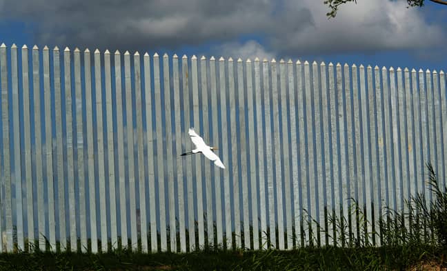
A man who spent $30 million (£22 million) on building Donald Trump's wall is looking to sell.

As reported by Bloomberg, Tommy Fisher, 51, was the man responsible for constructing a three-mile barrier made up of 15,000 18-foot-tall steel bollards layered out across the Mexico/US border along the Rio Grande river near Mission, Texas.

In 2019, the 51-year-old's North Dakota company, Fisher Industries, received $6.9 million (£5 million) to build a half-mile of the wall from We Build the Wall (WBTW), the organisation that was responsible for sourcing funds for construction

.
Tommy Fisher's border wall runs along the Rio Grande river near Mission, Texas. Credit: Eric Gay/AP/Shutterstock

The crowd sourcing company was founded by former US veteran Brian Kolfage and co-led by former White House strategist Steve Bannon.


Later on that same year, Fisher started to add another section to the wall and received an extra $1.5 million from Kolfage and Bannon.

However, Fisher was forced to part ways with the pair, who were later indicted for wire fraud, having being accused of diverting $1.3 million (£945k) of the donations for the border wall for their own personal use.

Both men pleaded not guilty. Bannon received a pardon from Trump in his final days as President, while Kolfage is set to appear in court in November.

For Fisher, costs for building the wall shot up to $30 million (£22 million) - 20 times more than original estimates

.
The wall cost a staggering $30 million. Credit: Eric Gay/AP/Shutterstock

Last year, the National Butterfly Center, a non-profit conservation organisation, sued WBTW and Fisher Industries, with environmentalists and the opposition were protesting against the construction as they believed that it was being built too close to the river and could lead to worse flooding.

The increase in value and change in presidency has left the infamous wall looking like a tough sell.

After winning the election, US President Joe Biden halted the building of Trump's wall, despite reports of the President considering restarting work on the wall in April.

Credit: PA
Last month, Biden returned $2.2 billion (£16 million) to the military forces that were allocated to building the barrier.


Initially, Fisher was really excited about the project and told Fox News: "I was like, 'This would be really fun. This would be a project that would be remembered, like the Hoover Dam."

He was hoping that his project would be the 'Lamborghini' of walls and someone would come in to buy it - and ideally pay him to extend it, with Fisher looking to charge $20 million per mile.

He told Bloomberg: "I just think they gotta take the stigma out of the wall as a racist kind of thing?

"It's a border, it's a barrier, that's all it means.

"Can you imagine if this was 50 to 100 miles, and this was a bike path you could use? Even if the Border Patrol was over here, minding their own business?"

Featured Image Credit: Fox News
For 60 Years, Indigenous Alaskans Have Hosted Their Own Olympics

Athletes at the World Eskimo-Indian Olympics in Fairbanks test their mettle in events like the blanket toss, knuckle hop and ear pull

SIMILAR SUMMER GAMES ARE PRACTICED IN THE YUKON, NWT, ARCTIC, NUNAVUIT, LABRABOR AND GREENLAND

The blanket toss is one of the many events that occur during the annual World Eskimo Indian Olympics in Fairbanks, Alaska.
SMITHSONIANMAG.COM
JULY 21, 2021

Every summer, Fairbanks, Alaska, plays host to one of the most important cultural events for Alaska Natives, the World Eskimo-Indian Olympics. Since 1961, the four-day event has been drawing athletes with Native heritage from the farthest reaches of the state and internationally to compete in a wide range of competitions, all linked to survival skills and cultural practices that have been deeply rooted within their communities for generations.

This year’s event is particularly salient considering last year’s was canceled due to the Covid-19 pandemic, marking the first time in the WEIO’s 60-year run that it had been called off. While WEIO’s history is relatively short in relation to the histories of the state’s many Alaska Native communities, which include but are not limited to the Inuit, Inupiat, Yupik and Athabascan (also spelled Athabaskan), that rich tapestry of different cultures is what led to the WEIO’s founding in the first place.

In 1961, two commercial airline pilots, Bill English and Tom Richards, Sr., who flew for the now-defunct Wien Air Alaska, were flying back and forth to some of the state’s outlying communities. During these visits, they watched Alaska Natives perform dances and other physical activities, such as the blanket toss, an event where 30 or more people hold a blanket made of hides and toss one person in the air. The goal is to remain balanced and land on one's feet. (The event stems from the Iñupiaq, an indigenous group from northern Alaska, who would use a blanket to toss a hunter in the air as a way to see over the horizon during hunts.)

“They [English and Richards] had a true appreciation for what they were witnessing and knew that these activities were something that people in the rest of the state should see for themselves to get a better understanding of the value of traditions happening outside Alaska's big cities,” says Gina Kalloch, chairwoman of the WEIO board who is Koyukon Athabascan.

That summer, the city of Fairbanks, with the support of the Fairbanks Chamber of Commerce and Wien Air Alaska, hosted the first WEIO, then simply known as the World Eskimo Olympics. A. E. “Bud” Hagberg and Frank Whaley, two employees of the airline, are credited as being the founders of WEIO. The airline even offered to fly athletes from their villages to the city to compete in a variety of events, many of them showcasing living traditions in Native culture. All told, four Eskimo dance groups, two Indian dance groups, and competitors in the high kick, blanket toss and seal skinning participated. A Miss Eskimo Olympics Queen contest also took place at the inaugural games.

An athlete competes in the two foot high kick competition at the WEIO. 
(Flickr user Fairbanks Mike)

Fast forward to today and thousands of spectators watch hundreds of athletes compete in nearly two dozen athletic events, all traditional games that long predate the WEIO. The knuckle hop tests competitors' endurance as they "hop" forward in a push-up position with only their knuckles and toes touching the floor. The four-man carry tests athletes' strength and ability to carry heavy loads for prolonged periods of time, much like hauling animal meat home after a successful hunt. And finally, the Indian stick pull mimics the skills needed to grab a fish out of the water, but in this case, two competitors try to pry a greased one-foot-long dowel out of the other's hand. The WEIO website describes the infamous ear pull as “a game of stamina” that involves two people with a piece of sinew looped behind each of their ears competing in a game of tug-of-war; they pull as hard as they can with the objective of ripping the sinew off their opponent’s ear. (Watch this video at your own risk.)

“The ear pull is specifically designed to be a competition to withstand pain,” Kalloch says. “The pain mimics what it’s like to experience frostbite and teaches people to learn to deal with pain. I did it once and I’ll never do it again, however my daughter won a gold medal in it.”

The infamous ear pull competition tests contestants' ability to overcome pain. (WEIO/Facebook)

Kalloch, however, is a gold medalist in the Alaskan high kick, an event that involves an athlete on the ground balancing on one hand while stretching a leg to kick a suspended object hanging in the air, such as a ball. She’s participated in a number of strength events too, like the Eskimo stick pull where two athletes sit on the ground while gripping their hands around a stick and pulling, with the objective of toppling the opponent over. The latter event tests skills similar to those needed to pull a seal from a hole in the ice during a winter hunt whereas the former is a common pastime among the Iñupiaq during the cold days of winter.


Kalloch says two of the most popular events at the Olympics are the one-foot high kick and the two-foot high kick, which require athletes to jump and kick at a suspended object while landing on their feet. The origin of these two events, which are different events from the Alaskan high kick, can be traced back to a form of communication that was used by residents of coastal fishing communities before the advent of walkie talkies and cell phones.

“In Alaska’s northern regions, it’s really flat and you can see for miles,” she says. “During hunts, one of the hunters would use different types of kicks to send signals back to the village to say whether someone was hurt or if they had a successful hunt and needed more people to assist in bringing back [the kill]. This form of communication would let them say anything you would want to communicate over the phone or by telegraph.”

Music and dance performances are an integral part of the WEIO. (WEIO/Facebook)

Amber Applebee, who is also Athabascan, has been competing in strength events like the Eskimo stick pull, arm pull (where two seated athletes loop arms at the elbow and try to pull their opponent upwards) and the greased pole walk (a game of balance where opponents walk barefoot across a greased log) at the WEIO for years. She’s also served as a coach for more than two decades, often competing against athletes whom she’s trained. Because the events aren’t divided by age group, it’s not uncommon for teenagers and young adults to go head-to-head (or ear to ear) with someone their senior. The only division the WEIO employs is gender. Athletes must be at least 12 years old to compete.

POWOW

“It’s a tradition amongst [Alaska Natives] to teach,” Applebee says. “Kids often grow up through this program and see their parents and grandparents competing. We look forward to attending the WEIO because we get to see relatives that we don’t often see. It’s like a big family reunion.”


Applebee, who has three children of her own, all of whom are medalists, says that camaraderie is a key part of the games, and that it’s not uncommon for competitors to cheer on their rivals.

“When my daughter was 13 and competing for the first time [at the WEIO] we also happened to be up against each other in the Indian stick pull,” Applebee says. “She kicked my butt and got gold; I got silver.”

Today, more than a decade later, her daughter is a judge.

“It’s really important for me to pass these traditions down from one generation to the next,” she says. “I want my children to know who we are and what our people did, and the WEIO is the best way to do that.”

While the WEIO is one of the largest organizations in Alaska nurturing these Native traditions for future generations, they're not alone. NYO Games Alaska offers its own lineup of games specifically geared toward athletes in their youth as a way to get them involved in cultural traditions from an early age. In addition, both agencies offer Alaska Natives the opportunity to continue practicing the traditions of their ancestors, which is especially important for those living in urban areas where they're less likely to come in contact with aspects of their heritage on a regular basis.

“[The WEIO] becomes more important year after year, since so many of our people have lost a connection to our land and our languages," Kalloch says. "Life changes cause people to move to the city to get jobs. In a way it’s progress, but with Native people, there’s always a loss attached to it. The Olympics give people the chance to connect with generations before them and the opportunity to do what their ancestors have done. We feel a strong need to hold on to what we can, which is what makes us who we are.”
COLONIALIST LOST WORLDISM
When Claims of ‘Discoveries’ in the Amazon Ring False

When news broke worldwide of an incredible find in Colombia, local experts and guides say their knowledge was ignored and the region was misrepresented

All members of the community interviewed for this story say the indigenous groups of the region have always known about the murals and recognize them as part of their cultural heritage. (DIANA SANCHEZ/AFP via Getty Images)

By Santiago Flórez
SMITHSONIANMAG.COM
JULY 22, 2021

In the Colombian Amazon rainforest tucked in towering table-top mountains known as Tepuis, thousands of pictographs can be found in large-scale murals. The paintings are located in Guaviare, a southeastern region of Colombia where the Amazon rainforest meets the plains of Colombia and Venezuela. Two locations there have confirmed rock paintings in this area: the Serranía de La Lindosa and Chiribiquete National Park. Together, they comprise the biggest collection of rock paintings in the Americas, and they have extraordinary archeological and cultural value.

About a year ago, in April 2020, a group of Colombian and English researchers led by Gaspar Moscote-Rios of the National University of Colombia published an article in the peer-reviewed journal Quaternary International, presenting the results of their archaeological research in Serranía de La Lindosa, a rock formation located 40 minutes from the city of San José de Guaviare. The team collected human and animal remains, charred seeds, and ochre fragments, the material used in the paintings. Using carbon-14 dating on some of the seeds, they were able to determine that the site was first settled between 11,800 and 12,600 years ago. Some of the pictographs located near their excavation site may even show depictions of extinct megafauna, the researchers hypothesized.


But later that year, the British television show “Jungle Mystery: Lost Kingdoms of the Amazon,” featured the Quaternary International paper and one of its authors as source material, yet asserted falsely that the rock paintings were a new discovery. In an article from the Guardian about the show, paleoanthropologist Ella Al-Shamah, who hosts the show, claimed, “The new site is so new, they haven’t even given it a name yet.”


Tucked in towering table-top mountains known as Tepuis, thousands of pictographs can be found in large-scale murals. (GUILLERMO LEGARIA/AFP via Getty Images)

International media, including, admittedly, Smithsonian magazine, repeated the reporting from the Guardian, and many news outlets didn’t mention Colombian research, ignored decades of studies on the subject, and misrepresented the local community.

Colombian archeologists, anthropologists and locals were outraged.

“It’s a big lie. Of course, the site has a name, Cerro Azul,” says Don José Noe, who owns the land where the murals are located. Per Noe, Cerro Azul is the name of a rock formation, archeological site and one of the murals located in the Serrania De La Lindosa. The team excavated at sites called Limoncillos and Cerro Montoya as well, all located within the Serrania de La Lindosa. “Locals have been visiting the murals for more than 60 years. I saw all the murals for the first time when I bought this terrain, 25 years ago,” Noe says. (All interviews were conducted in Spanish and translated by the author.)


“It makes me feel like we are still living in colonial times. The show and the articles in the media failed to recognize the existence of our community,” says Franf Garzón, director for Competitivity and Development for the city of San José del Guaviare. “For decades this community has been taking care of these murals.”
Ancient art covers a cliff face in Chiribiquete National Park, San Jose del Guaviare, Colombia. (Antoine Boureau/Getty )

All members of the community interviewed for this story say the indigenous groups of the region have always known about the murals and recognize them as part of their cultural heritage. Chiribiquete—the name of the national park where the largest and oldest paintings can be found—means “hills where it is drawn” in Karijona, an indigenous group who speak a language that is part of the Cariban linguistic family. Karijona is on the verge of disappearing; according to the Colombian government, fewer than 400 people speak it.

The rock paintings at Serrania de La Lindosa have been studied for decades in Colombia. The most laughable description may be written by the Italian-Venezuelan cartographer Agustin Codazzi, who received reports and dismissed them as scribbles made by bored Spanish soldiers during the conquest, around 1530 to 1545.

In 1943, ethnobotanist Richard Evans Schultes was likely the first scientist to write about the murals and their significance for the indigenous communities. Schultes was very clear in his diaries that he didn’t discover the paintings, instead he credits his indigenous guide, a young Karijona individual. He was so impressed with the region that he called it “God’s workshop.”

The first photographic evidence of the murals in la Serrania de La Lindosa was taken by French explorer and writer Alain Gheebrant in 1949. Since the 1960s, at least a dozen expeditions have been organized by different academic or governmental institutions.

For study co-author Jeison Lenis Chaparro-Cárdenas, the team’s results related to the ancient seeds were overlooked, despite having exciting implications. Using carbon dating the team was able to confirm the human presence and transformation of the Amazon rainforest landscape for thousands of years.

“The disinformation in the media obscured the results of our research. We were able to confirm human presence in the region 12,000 years ago,” says Chaparro-Cárdenas, an archaeologist at Universidad Nacional de Colombia in Bogotá.

But human presence in the region for thousands of years does not mean the paintings are just as old, says Fernando Urbina, a retired researcher at Universidad Nacional de Colombia in Bogotá who was not involved in the paper.
The rocks are covered in ochre-colored shapes, patterns, handprints, as well as animals and humans. (Photo by Juancho Torres/Anadolu Agency via Getty Images)

Media headlines in December 2020 emphasized the depictions of extinct megafauna, such as giant sloths, mammoths and extinct horses, in the murals, which would have roamed the region thousands of years ago. However, the interpretations of the paintings are still being debated, and alternate analyses were not included in most press coverage. Urbina has studied the murals in Guaviare since the 1970s. He suggests the paintings depict tension and violence between the indigenous community and Spanish colonizers.

“I believe those are the horses of the Spanish conquistadores… Many murals depict ceremonies, dances, and myths,” Urbina says. “Some also might show the terror inflicted by the Europeans. In some murals, there are images of dogs attacking or eating humans.” (Dogs arrived in the region with Spanish colonizers.)

To support his theory, Urbina cites a letter by German explorer Phillip Von Hutten, who travelled the region 500 years ago. In the letter, dated October 20, 1535, Von Hutten to his father:

“On [July] 23rd [Pedro de] Cárdenas brought 30 indians that he found with the sword and among other things of the dead christian [a reference to Antonio Ceballlos Sabala, a conquistador who had disappeared days prior searching for slaves within the natives]. Some of them had witnessed his death. Then the governor ordered that they should be torn apart by the dogs, and then distributed the survivors among the christians.”

Biologist and explorer Patricio Von Hilderbrand, who is now the scientific director at the nonprofit Fundación Puerto Rastrojo, lived in Chiribiquete National Park for ten years and explored the region extensively. He has observed several murals and also disagrees with the megafauna theory. Instead, Von Hilderbrand says the drawings show animals native to the rainforest.

“The animals that are depicted are the animals you can see in this region,” Von Hilderbrand says. For example, he thinks an image described as a giant sloth in the article really shows a capybara, an interpretation shared with Urbina.
The interpretations of the paintings are still being debated, and alternate analyses were not included in most press coverage when the research paper was published. (Photo by Juancho Torres/Anadolu Agency via Getty Images)

The debate is an important process in the scientific process. After all, these are theories that need more evidence to be confirmed. Chaparro-Cárdenas has spoken with Urbina since his team’s study was published. “Thanks to the discussions with professor Urbina we can conclude that the pictographs are showing horses,” Chaparro-Cárdenas explains. “Now we need to do more research to figure out if they are extinct horses or the horses of the conquistadores.”

In La Serrania de La Lindosa, indigenous groups were decimated by the rubber bonanza and later displaced by drug-related violence, but in Chiribiquete and Nukak Nature Reserve, there are reports of uncontacted tribes that are still painting in the Tepuis. During his studies in the region, Urbina interviewed an indigenous individual that was recruited as a child by FARC, who when escaping the guerrilla saw an indigenous group speaking an unknown language and painting a gigantic deer in a tepui in Chiribiquete. Chaparro-Cárdenas, says a Karijona shaman told him, “those paintings are a book about our history, a story that is still being told.”

Attitudes and tensions between scientists and locals have changed since Schultes visited the region. Anthropologist Luis Cayón wrote in his 2013 book Pienso, luego creo. La teoría makuna del mundo:


“For many natives, Doctor Schulte was the first white men they ever saw… he was remembered as respectful man, he joined them in their ceremonies, didn’t laughed of their food, and didn’t chased women, a clear contrast to many of his contemporaries.”

Rock art photographed at el Raudal del guayabero in Guaviare, Colombia, on March 25, 2021. (Juancho Torres/Anadolu Agency via Getty Images)


Although he never gave much credit to his collaborators, they still remember him fondly, and some like Oscar Romualdo Román Jitdutjaaño (Enokakuiodo), became well-known experts of the flora of the rainforest.

Today, the community in La Lindosa has become apprehensive of scientists that “come, collect, and study to never return or share their results with us,” states Garzón. “How much credit have local guides received for taking scientists or the British television show crew to the murals?”

“Everyone is invested in the preservation of the murals and the conservation of the biodiversity of Guaviare, we want and need researchers that are willing to share their results, help our youth to learn their expertise… after all we are the guardians of this territory," Garzón added.

Julián Niño, local explorer and tour guide, hopes the spotlight of the murals can bring “new prospects for environmental conservation and tourism in Guaviare, with new opportunities that will benefit the entire community.” Niño, like many other local guides, has assisted the work of many national and international scientists, often taking them to the sites they study, without any credit or recognition.


“People that come here to do research can involve the community more, empower us, teach us how to do research,” Niño says. “We want to participate in the exploration of our culture and our territory.”
Traces of Submerged Roman Road Found Beneath Venetian Lagoon

New research suggests the Italian city was settled earlier than previously believed
The road appears to have run along a sandy ridge between the northern and southern ends of the lagoon. (Rendering by Antonio Calandriello and Giuseppe D'Acunto / Photo by Fantina Madricardo)

By Livia Gershon
SMITHSONIANMAG.COM

Researchers in Italy have found the remains of a Roman road and dock at the bottom of a Venetian lagoon.

“We believe that what we found is a part of a road that connected the southern and the northern part of the Venice lagoon,” Fantina Madricardo, a geophysicist at the ISMAR-Marine Science Institute in Venice, tells the Art Newspaper’s Garry Shaw.

The pathway would have allowed people to travel to and from the ancient Roman city of Altinum, located at the north end of the lagoon.

As Madricardo and her colleagues write in the journal Scientific Reports, their findings suggest the area that became the lagoon was home to extensive Roman settlements long before the founding of Venice in the fifth century C.E. At the time, far more of what is now underwater would have been dry land.

“The Venice lagoon formed from the main sea-level rise after the last glaciation, so it's a long-term process,” Madricardo tells Live Science’s Tom Metcalfe. “We know that since Roman times—about 2,000 years—that the sea level there rose” up to eight feet.

Per Krista Charles of New Scientist, archaeologist Ernesto Canal first suggested that ancient artificial structures stood beneath the canal’s waters back in the 1980s. His idea sparked vigorous debate among researchers, but technology at the time didn’t allow for much exploration.

“The area is very difficult to investigate by divers because there are strong currents and the water in the Venice lagoon is very turbid,” Madricardo tells New Scientist.

When the road was built, sea levels were much lower, leaving the area that's now Venice drier than it is today. (szeke via Flickr under CC BY-NC-SA 2.0)

For the study, the researchers used a multibeam sonar device mounted on a boat to create 3-D images of the landscape on the lagoon floor. As the Guardian’s Angela Giuffrida reports, scuba divers in the 1980s had found what appeared to be paving stones in the lagoon. The new research was able to confirm that they were large, flattened stones similar to basoli used in the system of roads that ran throughout the Roman Empire. These rocks were placed down systematically along a sandy ridge that would have then been above water.

The team also found 12 structures, some as much as 9 feet high and 170 feet long, by the presumed route of the road, as well as what appear to have been docks. The researchers investigated them with the help of a team of divers from the local police force.

According to Haaretz’s Ariel David, historians have previously suggested that large-scale settlement of the Venice area only began in the fifth century, when refugees from the declining Western Roman Empire fled there to escape invasions.

“Venice was thought to have been built in a deserted place without any previous traces of human presence,” Madricardo tells Haaretz. “… Altinum was the main urban site in the region but now we believe that there were already multiple settlements in the lagoon that were connected to it and coexisted with it, so the migration to this area was a more gradual process that started earlier.”

Today, a changing climate is once again altering the landscape of the Venice area. In June, Italy’s National Environment Protection System issued a report warning of the “continual and irreversible” rise in sea levels that threatens the low-lying city. Last year, a set of controversial, inflatable floodgates saved Venice from a 4.6-foot tide that could have overwhelmed half the city, as Giuffrida reported for the Guardian at the time.
GREAT JOB! FOX NEWS BOLDLY CLAIMS RUSSIAN JET FLIES AT TWICE THE SPEED OF LIGHT.

SPOILERS: FOX WAS WRONG.


DRAGISA BRAUNOVIC / FUTURISM

Screw Your Physics

If you watch Fox News‘ morning talk show “Fox and Friends,” you may have heard some unsettling news about Russia’s military prowess.

Apparently, Russia has learned to violate the singular, most unbreakable law of physics, the speed limit of the universe that allows every other law of science to fall into place, all in the name of building a fast jet plane.

That’s right — “Fox and Friends” told its audience of 1.2 million that Russia developed a jet that “…can fly at a speed of almost twice the speed of light” in a clip that was shared on Twitter by Ron Filipowski, a former Florida state commissioner who resigned over the police raid of data analyst and COVID whistleblower Rebekah Jones’ home.


One-Way Trip

Needless to say, what the “Fox and Friends” host said is incorrect. And impossible. Like actually, physically, math-doesn’t-work-that-way impossible.

Propelling an object to the speed of light requires an infinite amount of energy. A jet traveling at that speed would immediately crumble into dust from the intense wind resistance, killing its pilot as all their blood pools, unable to circulate.

It would also be wildly impractical as a military tool, since one second of travel time would bring the pilot’s unrecognizable corpse way beyond the Moon.
Okay, Okay

To be fair, this is almost certainly a gaffe on the part of Fox News. Just moments before, the same host refers to the jet as “hypersonic,” which means “faster than sound.” But to be fair to Fox News‘ audience, that’s still a colossal screw-up.

One of the first rules of science journalism is to gut-check your data. That means making sure that you’re not saying “billion” when you mean “million” — and making sure you don’t imply that a Russian aircraft would punch a hole in the fabric of spacetime when you mean to say “it goes pretty fast.”

Yeesh!
RUSSIA’S SPACE STATION MODULE LAUNCH WAS FILLED WITH DRAMA
WAS THERE EVER ANYTHING WRONG WITH ITS MAIN ENGINES?


ROSCOSMOS


From Russia With Love

Despite confirming it would eventually abandon the International Space Station, Russia’s federal space agency Roscosmos had one last contribution to make.

Russia’s brand new space station module called Nauka successfully launched into space on Wednesday — but there was a change of plans once it entered space.

Unconfirmed reports emerged of a main engine failure cutting the module’s efforts to raise its orbit short. It’s an unfortunate bit of a drama for a space lab that was meant to launch in 2007, as Gizmodo points out, but had to be delayed due to technical problems at the time.
Raising Orbit

Fortunately, Roscosmos later announced on Twitter that the “test activation of the propulsion system of the module Nauka and the orbit formation impulse were worked out normally.”

As is characteristic of the space agency, the messaging around the incident was rather vague. It’s still unclear if Nauka’s main engines were ever ignited — or if there was an issue with them to begin with.

The agency released orbital parameters of two correction maneuvers, showing how its orbit was adjusted. “Thus, the telemetry confirmed the module propulsion unit operability,” the update read.

Harvard Center for Astrophysics astronomer Jonathan McDowell noted early Friday morning that Nauka’s orbital data shows that it is “still in the post-maneuver orbit, no additional orbit changes yet.”

Goodbye Pirs

The setback has forced Roscosmos to delay the departure of Russia’s outgoing Pirs module from the ISS, a 20-year-old segment that is scheduled to be de-orbited. The segment was meant to be replaced with the Nauka module. A pair of cosmonauts spent hours during a spacewalk in early June to set up the dismemberment of the module from the ISS.

Roscosmos has now delayed Pirs’ departure until Saturday so engineers have more time to figure out what to do with the Nauka module.

It’s an unfortunate kerfuffle — and arguably the last thing the space agency needs in its plans to establish its own space station.

READ MORE: Russia Averts Possible Disaster as New Space Station Module Finally Reaches Proper Orbit [Gizmodo]

More on Roscosmos: Russia Wants to Send a Nuclear-Powered “Space Tug” to Jupiter