A volcano has erupted in Iceland about 1.8 miles from a town that was evacuated weeks ago in preparation for the event.
By AP via Scripps News
Posted: 7:25 p.m. EST Dec 18, 2023
A volcanic eruption started Monday night on Iceland's Reykjanes Peninsula, turning the sky orange and prompting the civil defense to be put on high alert.
The eruption appears to have occurred about 1.8 miles from the town of Grindavík, the Icelandic Meteorological Office said. Webcam video from the scene appears to show magma, or semi-molten rock, spewing along the ridge of a hill.
In November, police evacuated the town or Grindavik after strong seismic activity in the area damaged homes and raised fears of an imminent eruption.
A coast guard helicopter will attempt to confirm the exact location — and size — of the eruption.
Grindavik, a fishing town of 3,400, sits on the Reykjanes Peninsula, about 31 miles southwest of the capital, Reykjavik and not far from Keflavik Airport, Iceland's main facility for international flights. The nearby Blue Lagoon geothermal resort, one of Iceland's top tourist attractions, has been shut at least until the end of November because of the volcano danger.
By David Keyton The Associated Press
Monday, December 18, 2023
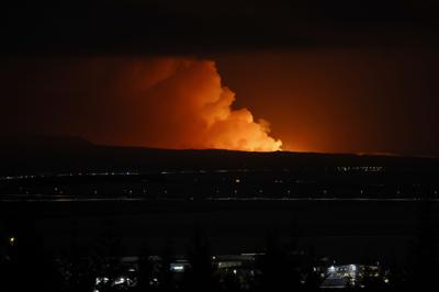
The night sky is illuminated caused by the eruption of a volcano on the Reykjanes peninsula of south-west Iceland seen from the capital city of Reykjavik, Monday Dec. 18, 2023.
STOCKHOLM (AP) — A volcanic eruption started Monday night on Iceland's Reykjanes Peninsula, turning the sky orange and prompting the country’s civil defense to be on high alert.
The eruption appears to have occurred about four kilometers (2.4 miles) from the town of Grindavik, the Icelandic Meteorological Office said. Grainy webcam video showed the moment of the eruption as a flash of light illuminating the sky at 22:17 local time. As the eruption spread, magma, or semi-molten rock, could be seen spewing along the ridge of a hill.
“The magma flow seems to be at least a hundred cubic meters per second, maybe more. So this would be considered a big eruption in this area at least,” Vidir Reynisson, head of Iceland’s Civil Protection and Emergency Management told the Icelandic public broadcaster, RUV.
In November, police evacuated the town or Grindavik after strong seismic activity in the area damaged homes and raised fears of an imminent eruption.
Iceland's Meteorological Office said in a statement early Tuesday that the latest measurements show “the magma is moving to the southwest and the eruption may continue in the direction of Grindavik.”
The size of the eruption and the speed of the lava flow is “many times more than in previous eruptions on the Reykjanes Peninsula in recent years,” the statement said.
Iceland sits above a volcanic hot spot in the North Atlantic and averages an eruption every four to five years. The most disruptive in recent times was the 2010 eruption of the Eyjafjallajokull volcano, which spewed huge clouds of ash into the atmosphere and grounded flights across Europe for days because of fears ash could damage airplane engines.
Scientists say a new eruption would likely produce lava but not an ash cloud.
Iceland’s foreign minister, Bjarne Benediktsson said on X, formerly known as Twitter, that there are “no disruptions to flights to and from Iceland and international flight corridors remain open.”
A coast guard helicopter will attempt to confirm the exact location — and size — of the eruption, and will also measure gas emissions.
Grindavik, a fishing town of 3,400, sits on the Reykjanes Peninsula, about 50 kilometers (31 miles) southwest of the capital, Reykjavik and not far from Keflavik Airport, Iceland’s main facility for international flights.
Published December 18, 2023

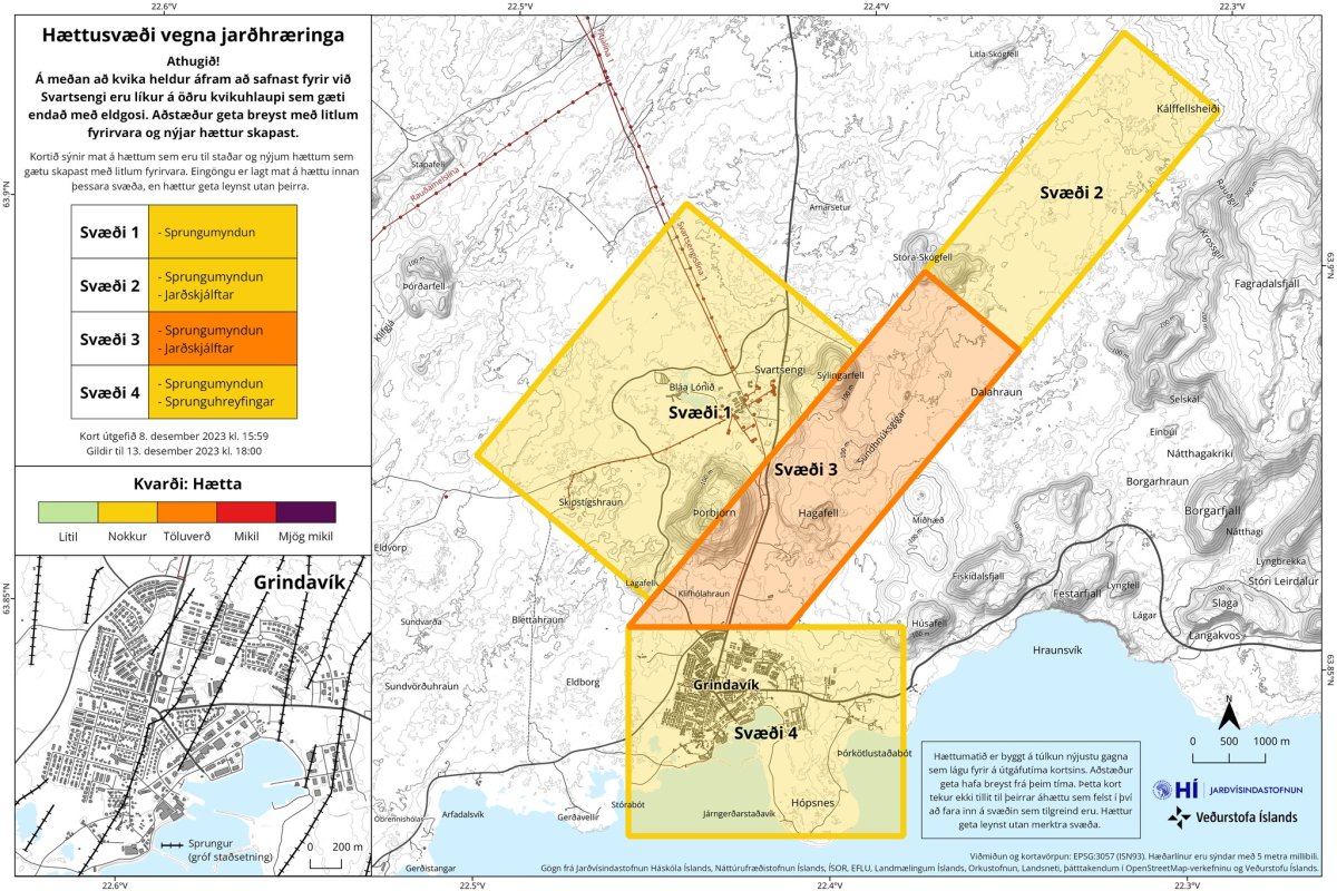
An eruption began on the Reykjanes peninsula around 21:00, in the area between Sýlingarfell and Hagafell, just north of the town of Grindavík and east of the Blue Lagoon and Svartsengi Power Plant. The fissure is estimated to be over 3 km long along Sundhnúkagígar crater row.
The start of the eruption was captured on the live webcam of the national broadcaster RÚV:
The live stream can be viewed here:
The glow from the eruption is visible from central Reykjavík.

Worst possible location
The Department of Civil Protection and Emergency Management has declared an Emergency/Distress Phase in response to the start of the eruption.
Volcanologist TT previously told the Grapevine the location along Sundhnúkagígar was the worst possible place for an eruption to begin to the likelihood of infrastructure being affected should lave breach the surface there.
Kristín Jónsdóttir, a volcano specialist with the met office told the national broadcaster shortly after the eruption began that the rate of lava flow is 100 to 200 cubic metres per second, which is significantly larger than the eruptions at Fagradalsfjall in 2021, 2022 and July 2023.
Kristín said it was difficult to predict how long the eruption would last. However, she thought it likely that given its initial size, it would last a few months rather than weeks.
The crater row at Sundhnúkargígar was created by an eruption 2,350 years ago.
Stay away, keep your drones grounded
Reykjanesbraut, the road running along the northern edge of the Reykjanes peninsula toward the international airport in Keflavík is closed in part due to a traffic jam. The area is closed. You will not be able to access the volcano site. Stay home to allow the authorities to monitor the situation and maintain a safe perimeter.
The no-fly zone that was established over a large swath of the area over the Blue Lagoon and GRindavík remains in effect. Isavia has provided the following coordinates within which it is forbidden to fly drones:
635621N0222218W
635440N0221323W
634902N0223533W
634641N0222232W
Under Observation
The Icelandic Meteorological Office has been monitor the area closely since seismic activity increased in late October. The activity came to a head on Nov. 10, when the met office identified a magma intrusion that had spread approximately 15 km from Sundhnúkagígar and running southwest under Grindavík and out beneath the sea floor. The 3.700 residents were evacuated at that time, but have been permitted in recent weeks to return to town between business hours.
The popular Blue Lagoon tourist attraction just reopened to the public in Dec. 17 after more than a month-long closure due to the alert phase in effect in the region. The local police chief said earlier today that signs were pointing toward residents being permitted to return home to Grindavík as well.
Read that news from just hours before the eruption began.
The Blue Lagoon has closed for business once again.
No comments:
Post a Comment