Denver to face temperature plunge from 99 to 32 in one day
September snow, cold to plunge across Rockies early this week
SEPT. 6, 2020

Los Angeles County sets record for highest temperature
Sunday's heatwave has politicians and power utilities calling on residents to conserve energy as tens of thousands lost power. Photo courtesy of Los Angeles Department of Water and Power/Twitter
Sept. 6 (UPI) -- The National Weather Service said Los Angeles County experienced its highest official temperature ever recorded on Sunday.
The federal agency said Woodland Hills registered a temperature of 121 degrees Fahrenheit just before 1:30 p.m. Sunday, topping the previous 119-degree record set on July 22, 2006.
"This broke the all-time record high temperature for the station," the NWS said in a 1: 32 p.m. statement. "This is also the highest temperature ever observed at an official recording station in Los Angeles County or in the Los Angeles County Warning Area, which includes San Luis Obispo County, Santa Barbara County, Ventura County and Los Angeles County."
Weather stations in Paso Robles, Santa Maria, Santa Barbara, Camarillo, Down Town Los Angeles, Long Beach, Burbank, Lancaster and Palmdale all registered high-temperature records on Sunday, the NWS said in a 6:18 p.m. update, adding that several of the records had stood since 1955.
RELATED National Guard says California on pace for record wildfire season
The heat spike caused the California Independent System Operator to issue an energy conservation warning that was to be in effect until 9 p.m.
"It's time, California," it said on Twitter. "Let's do this together."
Los Angeles Mayor Eric Garcetti said the heatwave was causing power outages throughout the city and crews would be working to restore the power as soon as possible.
"Time to turn off major appliances, set the thermostat to 78 degrees (or use a fan instead), turn off excess lights and unplug any appliances you're not using," the mayor tweeted. "We need every Californian to help conserve energy. Please do your part."
More than 60,000 homes were without power as of 8 p.m. PDT, according to poweroutage.us.
The Los Angeles Department of Water and Power estimated power would be restored between 24 to 36 hours from the start of the outage
Sunday's record occurred nearly a month after California's Death Valley registered what may have been Earth's hottest temperature ever recorded at 130 degrees on Aug. 16.
Denver to face temperature plunge from 99 to 32 in one day
By Chaffin Mitchell, Accuweather.com
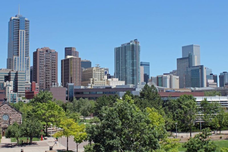
Forecasters are predicting a high of 99 degrees Fahrenheit in Denver on Sunday afternoon, followed by a low of 34 degrees on Monday night. Photo by mrminibike/pixabay
Sept. 6 (UPI) -- Residents in Denver are set to experience summer and winterlike temperatures within the span of just 24 hours.
Forecasters are predicting a high of 99 degrees Fahrenheit in Denver on Sunday afternoon, followed by a low of 34 degrees on Monday night, which could be a record-setting temperature drop.
"This would be the earliest in recorded history that a swing of this magnitude occurs," AccuWeather Meteorologist Jake Sojda said. Sojda said this is due to a powerful storm system and large dip in the jet stream that will direct a shot of Arctic air into the Plains and central Rockies from Monday through Tuesday.
"The flat terrain of the High Plains allows strong, gusty northerly winds to push the fresh Arctic air southward along the Front Range very quickly and efficiently. The air doesn't have time to moderate leading to a very sharp change in temperature," Sojda said.
While Sojda says a 50- to 60-degree temperature change in one day is not particularly uncommon in Denver, and has happened many times in the city since weather data recording began in Denver in 1872, usually a surge of Arctic air like this happens in the winter months. This will likely be the most significant push of cold air between November and February.
"The previous record was from Sept. 19, 2010, when the temperature fell from 96 to 41 in one day, a 55-degree drop. The next earliest was Oct. 9, 2019, another 55-degree drop when when the temperature went from a high of 83 to a low of 28," Sojda said.
The all-time record for the largest one-day temperature change occurred on Jan. 25th, 1872, when Denver fell from a high of 46 to a low of -20, a 66-degree change, Sojda reports.
"With a forecast high in the low to mid-90s on Monday, and then a low in the low to mid-30s Monday night, this event could fall in the top five all-time for one-day changes, but will likely fall a little short of the all-time record," Sojda said.
Still, for it technically being summer, this is going to be a historic event
RELATED September snow, cold to plunge across Rockies early this week
"There was also a two-day temperature change of 76 degrees on Dec. 14, 2008, when Denver went from a high 58 to a low -18," Sojda said.
Severe thunderstorms are not expected to be triggered from this, according to Sojda, but strong and locally damaging wind gusts as well as heavy snow in higher elevations will be a problem.
"Because of the heat leading up to this, in cities like Denver, the ground and especially paved surfaces will still have a lot of heat content. This is going to make it difficult for snow to accumulate and snow totals will almost certainly be much lower than if it were mid-winter. Still, elevated surfaces can still cool very rapidly and turn icy. This could make bridges and overpasses icy, even if snow isn't piling up on the ground around them," Sojda said.
Higher elevations, above 6,000 to 7,000 feet, will get colder, and the heat still contained in the ground may be eliminated more efficiently, Sojda said, which allows for more accumulation and even some slushy and icy roads.
"The drastic change in temperature can also have a big effect on infrastructure. Railroads, in particular, are susceptible as the rail lines can warp and buckle both with the extreme heat but also the extreme change," Sojda said.
According to AccuWeather Lead Storm Warning Meteorologist Brian Knopick, the rails expand in the high heat, and sometimes measures need to be taken to allow for this expansion without damage occurring to the rails. But, then when the temperatures rapidly drops 40 or 50 degrees or more, the rail contracts again and can leave gaps at the seams.
If these become large enough, they can damage the wheels of a train and even cause it to derail.
upi.com/7035992
September snow, cold to plunge across Rockies early this week
By
Courtney Spamer, Accuweather
(0)

Sept. 6 (UPI) -- A drastic temperature swing and a dose of early season snow will have residents from Montana to New Mexico wondering what month it is by Tuesday.
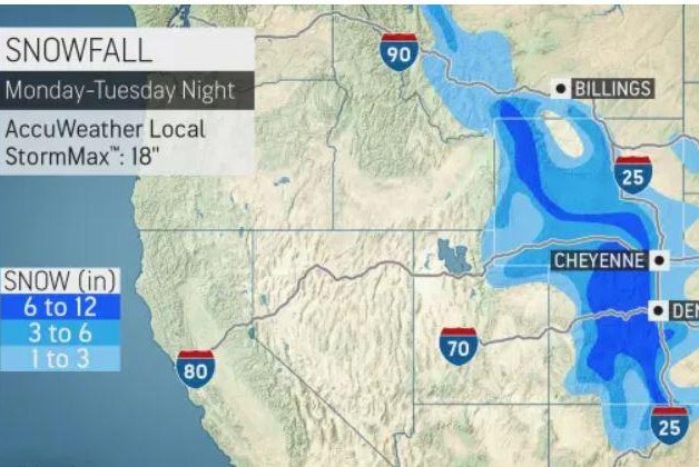
A storm is forecast to bring a mixture of rain and snow across the Intermountain West and the Plains Monday through Tuesday night, spreading precipitation from northern Montana to Texas.
Snow is forecast to begin falling in the northern Rockies of Montana and Wyoming on Monday, before extending southward through northeastern Utah, Colorado, and northern New Mexico into midweek.
Ski resorts in Montana have had a few snow showers already this year. Big Sky Resort in southwestern Montana got a few flakes on the last day of meteorological summer, Aug. 31.
"Snow is common for the northern Rockies in the month of September, but the earliest measurable snow accumulation on record for a place like Denver is Sept. 3," said AccuWeather Meteorologist Nicole LoBiondo.
With snow set to arrive in the greater Denver area early Tuesday, that's less than a week after the earliest snowfall on record.
A significant snowfall is in store above 7,000 feet, on average, from western Montana to Wyoming and Colorado. It is in this area that 6-12 inches of snow is forecast and an AccuWeather Local StormMax™ of 18 inches is possible.
With elevations of 5,000 to 7,000 feet from Montana to northern New Mexico, a few inches of snow can fall, especially on non-paved surfaces. But, overall, snowfall levels will tend to be lower across the northern part of the Rockies, amounting to more snow.
Elevations below 5,000 feet are forecast to see a few flakes, which at times are likely to be mixed in with rain. Perhaps enough snow could fall for a dusting of snow on non-paved surfaces, but any accumulations will likely be slushy.
Roadways are likely to initially be wet given the magnitude of the heat ahead of the storm. As the cold air arrives with the storm and the ground begins to cool, however, roads and sidewalks could turn slick early on Tuesday. Pedestrians and motorists alike should be aware of the risk for slippery travel.
The weight of the snowfall on fully leafed trees could cause limbs and branches to break. In addition to damage to trees, fallen limbs could also lead to more widespread power outages.
In addition to the snow, this storm will usher in a temperature swing of as much as 65 degrees Fahrenheit in less than 48 hours.
A dip in the jet stream will allow cold air from Canada to rush southward and bring record-challenging low temperatures in cities like Billings, Mont., Cheyenne, Wyo., and Denver.
After Denver set an all-time record high for September of 101 on Saturday, a strong cold front of the will help cold air to infiltrate the Colorado capital, bringing temperatures into the 30s Monday night.
No comments:
Post a Comment