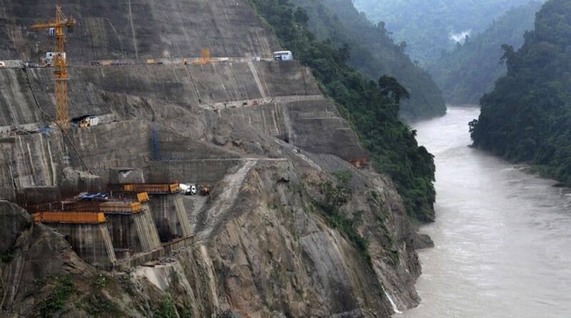
Location of India's Upper Siang Multipurpose Project
July 26, 2026
By P. K. Balachandran
Key Takeaways:
Geostrategic Framing vs. Practical Limits: India is increasingly presenting the 11,200 MW Upper Siang dam as a safeguard against China’s upstream Yarlung Tsangpo project, yet the reservoir’s defensive value depends on uncertain timing, levels, and operators’ ability to respond to events originating outside India’s borders, while construction itself would take about a decade and leave temporary works vulnerable.
High Ecological, Seismic and Climate Risks: The project sits in a densely forested, biodiverse, and highly seismic Himalayan zone (highest risk classification); it risks large-scale inundation of forests and habitats, disruption of river ecosystems, and amplified dangers from glacial lake outburst floods and extreme weather, as illustrated by the 2023 Teesta III dam collapse in Sikkim.
Local Opposition and Call for Pause: Adi communities and traditional bodies strongly oppose the dam due to displacement of villages, loss of ancestral lands and cultural identity; the article urges an independent cumulative basin-wide assessment and genuine prior consent before any further progress.
India’s proposed Upper Siang Multipurpose Project is no longer being discussed merely as a hydropower project. It is increasingly being framed as a geostrategic safeguard.
The roughly 11,200-megawatt project in Arunachal Pradesh is expected to generate electricity, moderate floods and store water on the Siang—the principal Indian channel of the Brahmaputra. But its strategic purpose is increasingly difficult to separate from China’s construction of a much larger hydropower project upstream on the Yarlung Tsangpo in Tibet. Indian officials argue that a massive reservoir on the Siang could protect the country against either the diversion of water during the dry season or a sudden release during periods of high flow.
That concern should not be dismissed entirely. China’s upstream plans are of legitimate consequence to India, Bangladesh and every community dependent on the Brahmaputra basin. Beijing’s assurances that its project will not harm downstream countries cannot simply be taken at face value. But neither should New Delhi’s.
The question is not whether India has reason to worry about what China is building upstream. As a matter of precaution, it has to. The question is whether constructing another Himalayan mega-dam, in one of the most ecologically fragile and seismically active regions in the world, is an intelligent answer to that risk.
So far, the Upper Siang project remains at the preparatory and survey stage. Full construction has not begun. Yet the political language surrounding it increasingly suggests that the conclusion has already been reached and that environmental studies, village consultations and pre-feasibility surveys are merely obstacles to be cleared afterward. That is where the problem begins.
A project of this scale cannot be justified simply because it has been given the label of national security. The larger the strategic claim, the greater the need for scrutiny. Instead, geostrategy risks becoming a device through which every objection—from displacement to seismic danger—is treated as secondary to an emergency defined in New Delhi.
India’s own strategic reasoning also contains an uncomfortable weakness. The proposed reservoir is expected to store as much as 14 billion cubic metres of water and remain partly empty so that it can absorb an unexpected upstream surge. But the usefulness of that defence depends on reservoir levels, the timing and volume of any release, the condition of the dam and the ability of operators to anticipate an event originating beyond India’s border.
It would also take around a decade to construct the project after work formally begins. During that period, temporary structures and unfinished works could themselves remain exposed to an upstream flood, landslide-generated surge or sudden release. A defence mechanism that becomes particularly vulnerable while it is being built cannot be treated as a simple strategic solution.
The project’s ecological cost is no less troubling. The Siang basin covers more than 15,000 square kilometres, over 82 per cent of which is covered by forest. It forms part of the wider Dihang–Dibang and Siang landscape, recognised for its dense forests, rare species and exceptional biological diversity. A storage project of this size would not affect only the location where concrete is poured. Reservoir formation and altered flow would inundate forests, separate habitats, disrupt fish migration, aquatic food chains and the seasonal rhythms upon which farming communities depend.
The geological risk is harder to dismiss and cannot be overstated. Arunachal Pradesh lies within India’s highest traditional seismic-risk classification. The eastern Himalayas are not an old and settled geological formation. They remain tectonically active, heavily fractured and vulnerable to earthquakes, landslides and slope failure. The magnitude-8.6 Assam–Tibet earthquake of 1950 triggered extensive landslides, ground fractures and river blockages across the region.
This does not mean that Upper Siang will inevitably cause an earthquake. It means that placing one of India’s largest dams in such terrain demands far more than a routine environmental clearance.
The geological hazard would be further accentuated by climate change and it should not be viewed as a peripheral threat. Glacial retreat, extreme rainfall and glacial lake outburst floods are increasing the danger of sudden surges carrying water, rock and sediment. The collapse of the Teesta III dam during the 2023 glacial lake outburst flood in Sikkim should have ended the belief that Himalayan hydropower structures can be assessed using historical averages alone. That disaster demonstrated how quickly an extreme event can overwhelm infrastructure regarded as a source of clean energy and regional development.
The communities of the Siang Valley understand that they will be the first to live with these risks and have chosen to not remain silent. Adi villagers, farmers, students and traditional leaders have repeatedly protested against the project, warning that ancestral land, agriculture and cultural identity could disappear beneath the reservoir. Reuters reported that at least 16 Adi villages could be lost to the reservoir, directly affecting around 10,000 people, while community representatives argue that the wider number affected could exceed 100,000.
Residents from more than 27 villages have opposed survey activities. In May 2025, central armed personnel were deployed near proposed survey locations, as authorities attempted to move forward with pre-feasibility work. Student organisations and local groups protested what they regarded as an effort to conduct surveys under coercive conditions rather than through meaningful consultation.
The Adi Bane Kebang, the apex traditional body of the Adi community, later rejected the project and demanded the withdrawal of the forces deployed for the survey. For the Adi, the Siang is not simply a volume of water waiting to be converted into electricity. It is Ane Siang—the sacred river around which land, agriculture, customary practice and cultural memory have developed.
The Arunachal Pradesh government has pointed to survey permissions granted in parts of the project area. But permission to conduct preliminary studies is not the same as consent for the dam itself. The project’s final footprint, displacement burden and cumulative risks remain unsettled, making any suggestion of broad public endorsement premature.
Compensation offers no answer to what would be permanently lost. Financial payments may cover property on paper, but they cannot restore ancestral land, river-based livelihoods or the social and cultural life built around the Siang. Once submerged, these losses cannot be recovered.
New Delhi should not allow frustration with Beijing to stampede it into a project whose ecological, geological and human costs have not been honestly settled.
At minimum, work on the Upper Siang project should be paused until an independent cumulative assessment is completed for the entire basin. That assessment must include reservoir-triggered seismicity, glacial lake outburst floods, sediment loading, dam-break scenarios, downstream effects and the combined impact of other planned hydropower projects.
Most importantly, the people of the Siang Valley must not be treated as another risk to be managed. Their consent must precede the project, not be assembled village by village after the state has already decided to proceed.
One Himalayan mega-dam does not become a sound answer merely because an even larger one is being constructed across the border. If approached without the necessary caution, Upper Siang could become not a shield against disaster, but the setting for another one—much like the destruction of the Teesta III dam in Sikkim. A threat upstream cannot be converted into wisdom downstream simply by wrapping it in the language of national security.
About P. K. Balachandran
P. K. Balachandran is a senior Indian journalist working in Sri Lanka for local and international media and has been writing on South Asian issues for the past 21 years.
View all posts by P. K. Balachandran

No comments:
Post a Comment